![](/images/other/stat-length.png)
![Randonnée V.T.T. Vernon - Circuit de la Colline aux oiseaux - Vernon - Photo](https://media.geolcdn.com/t/1900/400/ext.pjpeg?maxdim=2&url=https%3A%2F%2Fservices.sitytrail.com%2FGeolivesWS%2FDownloadMedia.ashx%3FTrailID%3D112577%26Media%3D10990_2.jpg)
Circuit de la Colline aux oiseaux - Vernon
tracegps
Utilisateur
![Longueur](/images/other/stat-length.png)
Longueur
5,9 km
![Altitude max](https://static1.geolcdn.com/siteimages/upload/files/1508320355ic_sort_altitude_max_24dp.png)
Altitude max
110 m
![Dénivelé positif](https://static1.geolcdn.com/siteimages/upload/files/1508320355ic_sort_den_pos_24dp.png)
Dénivelé positif
106 m
![Km-Effort](/images/other/stat-length.png)
Km-Effort
7,3 km
![Altitude min](https://static1.geolcdn.com/siteimages/upload/files/1508320355ic_sort_altitude_min_24dp.png)
Altitude min
12 m
![Dénivelé négatif](https://static1.geolcdn.com/siteimages/upload/files/1508320355ic_sort_den_neg_24dp.png)
Dénivelé négatif
107 m
![Boucle](https://static1.geolcdn.com/siteimages/upload/files/16400158638029165_repeat_loop_refresh_sync_direction_icon.png)
Boucle
Oui
Date de création :
2014-12-10 00:00:00.0
Dernière modification :
2014-12-10 00:00:00.0
![V.T.T.](https://static1.geolcdn.com/sitytour/trail-icons/202.png)
30m
Difficulté : Facile
![Scannez ce code QR pour ouvrir la randonnée dans l'application SityTrail](https://capi.geolives.com/qq0zvz2zws4bq2lad0pu/sitytour/trails/112577/qr.png?size=200)
Application GPS de randonnée GRATUITE
À propos
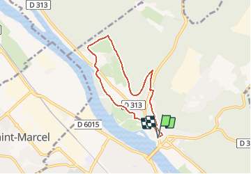
Randonnée V.T.T. de 5,9 km à découvrir à Normandie, Eure, Vernon. Cette randonnée est proposée par tracegps.
Description
Circuit proposé par la commune de Vernon. Départ du château des Tourelles. Circuit de difficulté moyenne et non accessible aux VTT. Chaussures de marche recommandées. Retrouvez les circuits de Vernon sur le site de la commune.
Localisation
Pays :
France
Région :
Normandie
Département/Province :
Eure
Commune :
Vernon
Localité :
Unknown
Départ:(Dec)
Départ:(UTM)
389701 ; 5439489 (31U) N.
Commentaires
Randonnées à proximité
![Randonnée Marche Vernon - Les falaises de Seine de Vernon à Mantes la Jolie - Photo](https://media.geolcdn.com/t/375/260/5fb6d91d-220e-4b46-8986-f386f1d9411e.jpg&format=jpg&maxdim=2)
![Marche Marche](https://static1.geolcdn.com/sitytour/trail-icons/101.png)
Les falaises de Seine de Vernon à Mantes la Jolie
Marche
Difficile
Vernon,
Normandie,
Eure,
France
![](/images/other/stat-length.png)
37 km | 47 km-effort
7h 38min
![](https://static1.geolcdn.com/siteimages/upload/files/16400158638029165_repeat_loop_refresh_sync_direction_icon.png)
Non
![Randonnée Marche Giverny - 076-104-Giverny Matin 12km-526-030- - Photo](https://media.geolcdn.com/t/375/260/2efe6bca-4705-4852-8c25-252c9af261ae.jpg&format=jpg&maxdim=2)
![Marche Marche](https://static1.geolcdn.com/sitytour/trail-icons/101.png)
076-104-Giverny Matin 12km-526-030-
Marche
Facile
(2)
Giverny,
Normandie,
Eure,
France
![](/images/other/stat-length.png)
9,2 km | 11,5 km-effort
2h 32min
![](https://static1.geolcdn.com/siteimages/upload/files/16400158638029165_repeat_loop_refresh_sync_direction_icon.png)
Oui
![Randonnée Marche La Chapelle-Longueville - Saint Just - Les coteaux de Seine - Photo](https://media.geolcdn.com/t/375/260/ext.jpg?maxdim=2&url=https%3A%2F%2Fstatic1.geolcdn.com%2Fsiteimages%2Fupload%2Ffiles%2F1553511878bg_sport_marche.png)
![Marche Marche](https://static1.geolcdn.com/sitytour/trail-icons/101.png)
Saint Just - Les coteaux de Seine
Marche
Facile
(4)
La Chapelle-Longueville,
Normandie,
Eure,
France
![](/images/other/stat-length.png)
10,5 km | 13,8 km-effort
2h 57min
![](https://static1.geolcdn.com/siteimages/upload/files/16400158638029165_repeat_loop_refresh_sync_direction_icon.png)
Oui
![Randonnée Marche Giverny - Giverny Le lézard vert - Photo](https://media.geolcdn.com/t/375/260/b5c62cc3-3474-47fb-9b85-16cd33879457.jpg&format=jpg&maxdim=2)
![Marche Marche](https://static1.geolcdn.com/sitytour/trail-icons/101.png)
Giverny Le lézard vert
Marche
Difficile
Giverny,
Normandie,
Eure,
France
![](/images/other/stat-length.png)
5,7 km | 7,5 km-effort
1h 57min
![](https://static1.geolcdn.com/siteimages/upload/files/16400158638029165_repeat_loop_refresh_sync_direction_icon.png)
Non
![Randonnée Marche Giverny - Giverny : les coteaux vers le Vexin 13 km - Photo](https://media.geolcdn.com/t/375/260/c82fb9e5-5a3f-476d-97d5-3fb681dd4a31.jpg&format=jpg&maxdim=2)
![Marche Marche](https://static1.geolcdn.com/sitytour/trail-icons/101.png)
Giverny : les coteaux vers le Vexin 13 km
Marche
Très facile
Giverny,
Normandie,
Eure,
France
![](/images/other/stat-length.png)
14,7 km | 17,8 km-effort
4h 51min
![](https://static1.geolcdn.com/siteimages/upload/files/16400158638029165_repeat_loop_refresh_sync_direction_icon.png)
Non
![Randonnée Moteur Giverny - Giverny , les Coteaux avril 2019 - Photo](https://media.geolcdn.com/t/375/260/ext.jpg?maxdim=2&url=https%3A%2F%2Fservices.sitytrail.com%2FGeolivesWS%2FDownloadMedia.ashx%3FTrailID%3D1143131%26Media%3Dfix__20190408160534.jpg)
![Moteur Moteur](https://static1.geolcdn.com/sitytour/trail-icons/400.png)
Giverny , les Coteaux avril 2019
Moteur
Moyen
Giverny,
Normandie,
Eure,
France
![](/images/other/stat-length.png)
13,6 km | 16,5 km-effort
3h 28min
![](https://static1.geolcdn.com/siteimages/upload/files/16400158638029165_repeat_loop_refresh_sync_direction_icon.png)
Non
![Randonnée Moteur Giverny - Giverny , les Coteaux avril 2019 - Photo](https://media.geolcdn.com/t/375/260/ext.jpg?maxdim=2&url=https%3A%2F%2Fservices.sitytrail.com%2FGeolivesWS%2FDownloadMedia.ashx%3FTrailID%3D1134663%26Media%3Dfix__20190408160534.jpg)
![Moteur Moteur](https://static1.geolcdn.com/sitytour/trail-icons/400.png)
Giverny , les Coteaux avril 2019
Moteur
Moyen
Giverny,
Normandie,
Eure,
France
![](/images/other/stat-length.png)
13,6 km | 16,5 km-effort
3h 28min
![](https://static1.geolcdn.com/siteimages/upload/files/16400158638029165_repeat_loop_refresh_sync_direction_icon.png)
Non
![Randonnée Moteur Giverny - Giverny , les Coteaux avril 2019 - Photo](https://media.geolcdn.com/t/375/260/ext.jpg?maxdim=2&url=https%3A%2F%2Fservices.sitytrail.com%2FGeolivesWS%2FDownloadMedia.ashx%3FTrailID%3D1132418%26Media%3Dfix__20190408160534.jpg)
![Moteur Moteur](https://static1.geolcdn.com/sitytour/trail-icons/400.png)
Giverny , les Coteaux avril 2019
Moteur
Moyen
Giverny,
Normandie,
Eure,
France
![](/images/other/stat-length.png)
13,6 km | 16,5 km-effort
3h 28min
![](https://static1.geolcdn.com/siteimages/upload/files/16400158638029165_repeat_loop_refresh_sync_direction_icon.png)
Non
![Randonnée V.T.T. Vernon - Les prés de Vernonnet - Vernon - Photo](https://media.geolcdn.com/t/375/260/ext.jpg?maxdim=2&url=https%3A%2F%2Fservices.sitytrail.com%2FGeolivesWS%2FDownloadMedia.ashx%3FTrailID%3D112611%26Media%3D11135_5.jpg)
![V.T.T. V.T.T.](https://static1.geolcdn.com/sitytour/trail-icons/202.png)
Les prés de Vernonnet - Vernon
V.T.T.
Facile
Vernon,
Normandie,
Eure,
France
![](/images/other/stat-length.png)
3,3 km | 3,7 km-effort
19min
![](https://static1.geolcdn.com/siteimages/upload/files/16400158638029165_repeat_loop_refresh_sync_direction_icon.png)
Oui