![](/images/other/stat-length.png)
![Randonnée Marche Plumelec - Circuit des Carrières - Saint Aubin - Photo](https://media.geolcdn.com/t/1900/400/ext.pjpeg?maxdim=2&url=https%3A%2F%2Fstatic1.geolcdn.com%2Fsiteimages%2Fupload%2Ffiles%2F1553511878bg_sport_marche.png)
Circuit des Carrières - Saint Aubin
tracegps
Utilisateur
![Longueur](/images/other/stat-length.png)
![Altitude max](https://static1.geolcdn.com/siteimages/upload/files/1508320355ic_sort_altitude_max_24dp.png)
![Dénivelé positif](https://static1.geolcdn.com/siteimages/upload/files/1508320355ic_sort_den_pos_24dp.png)
![Km-Effort](/images/other/stat-length.png)
![Altitude min](https://static1.geolcdn.com/siteimages/upload/files/1508320355ic_sort_altitude_min_24dp.png)
![Dénivelé négatif](https://static1.geolcdn.com/siteimages/upload/files/1508320355ic_sort_den_neg_24dp.png)
![Boucle](https://static1.geolcdn.com/siteimages/upload/files/16400158638029165_repeat_loop_refresh_sync_direction_icon.png)
![Marche](https://static1.geolcdn.com/sitytour/trail-icons/101.png)
3h15
Difficulté : Moyen
![Scannez ce code QR pour ouvrir la randonnée dans l'application SityTrail](https://capi.geolives.com/qq0zvz2zws4bq2lad0pu/sitytour/trails/112538/qr.png?size=200)
Application GPS de randonnée GRATUITE
À propos
Randonnée Marche de 9,4 km à découvrir à Bretagne, Morbihan, Plumelec. Cette randonnée est proposée par tracegps.
Description
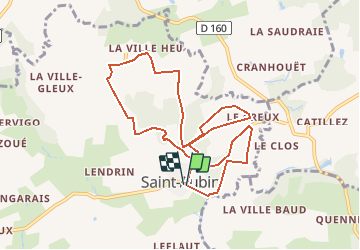
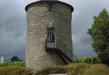
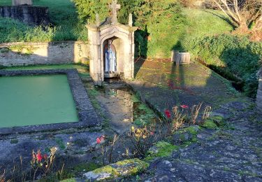
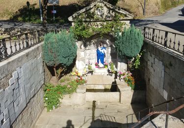
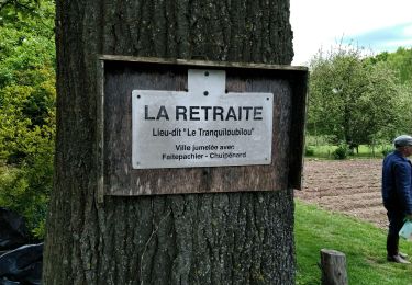
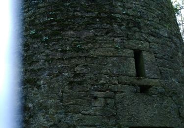
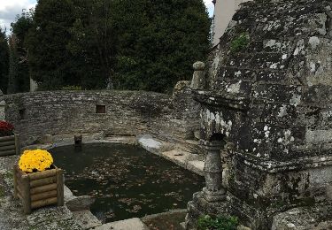
Point de départ : Saint Aubin (Commune de Plumelec) - (coordonnées GPS : 02° 34’ 85’’ O / 47° 50’ 71’’ N) - Distance : 13 km (3h15) A voir en chemin: Le bourg et l’église Saint-Aubin : le village présente un ensemble de maisons intéressantes ainsi qu’une église datant du XVIème siècle. Cette église porte les armes de Callac ainsi que le nom du fondateur, Jehan de Callac, la date de construction (1513) et les noms des ouvriers, Jehan et Guillemot Nyvet. Elle est célèbre pour ses magnifiques sablières. Fontaine St-Maurice : au bas du bourg, ce petit monument s’ouvre par une porte en accolade sur une niche contenant la statue du saint. Saint-Maurice, représenté en chevalier, est invoqué pour la guérison des rhumatismes. Son pardon se célèbre le dimanche suivant le 22 septembre. Kervigo : ancienne croix celtique érigée à proximité de la « Mare-au-sang », où s’est déroulé le terrible combat mené en 938 par le seigneur du Porhoët pour repousser l’invasion des Normands. Les carrières : le long de la route, se trouvent les carrières du « Chêne planté », des « grandes buttes », du « nid du Chat Huant » dont on a extrait les blocs de granite des statues du chemin de croix de Callac, et les carrières des Boulfrasses.
Localisation
Commentaires
Randonnées à proximité
![Randonnée Vélo Plumelec - Le petit Codoudal - Plumelec - Photo](https://media.geolcdn.com/t/375/260/ext.jpg?maxdim=2&url=https%3A%2F%2Fservices.sitytrail.com%2FGeolivesWS%2FDownloadMedia.ashx%3FTrailID%3D105596%26Media%3D9365_3.jpg)
![Vélo Vélo](https://static1.geolcdn.com/sitytour/trail-icons/200.png)
Vélo
![](/images/other/stat-length.png)
![](https://static1.geolcdn.com/siteimages/upload/files/16400158638029165_repeat_loop_refresh_sync_direction_icon.png)
![Randonnée Marche Plumelec - PR_56_Plumelec_AA_01_Circuit1b_Des-Carrieres_20231128 - Photo](https://media.geolcdn.com/t/375/260/52ebcca8-2a99-449e-a08e-c4d2788c3393.jpg&format=jpg&maxdim=2)
![Marche Marche](https://static1.geolcdn.com/sitytour/trail-icons/101.png)
Marche
![](/images/other/stat-length.png)
![](https://static1.geolcdn.com/siteimages/upload/files/16400158638029165_repeat_loop_refresh_sync_direction_icon.png)
![Randonnée Marche Saint-Servant - GR_347_AE_05_St-Servant_Josselin_20190830 - Photo](https://media.geolcdn.com/t/375/260/688882ab-8277-4be6-b3d4-bcd62681374a.jpg&format=jpg&maxdim=2)
![Marche Marche](https://static1.geolcdn.com/sitytour/trail-icons/101.png)
Marche
![](/images/other/stat-length.png)
![](https://static1.geolcdn.com/siteimages/upload/files/16400158638029165_repeat_loop_refresh_sync_direction_icon.png)
![Randonnée A pied Lizio - Sentier des Landes - Photo](https://media.geolcdn.com/t/375/260/ext.jpg?maxdim=2&url=https%3A%2F%2Fstatic1.geolcdn.com%2Fsiteimages%2Fupload%2Ffiles%2F1545311037marcheuse_200dpi.jpg)
![A pied A pied](https://static1.geolcdn.com/sitytour/trail-icons/100.png)
A pied
![](/images/other/stat-length.png)
![](https://static1.geolcdn.com/siteimages/upload/files/16400158638029165_repeat_loop_refresh_sync_direction_icon.png)
![Randonnée Marche Plumelec - Plumelec Cadoudal - Photo](https://media.geolcdn.com/t/375/260/4527036b-5a44-46cb-b500-7c0d80d36167.jpg&format=jpg&maxdim=2)
![Marche Marche](https://static1.geolcdn.com/sitytour/trail-icons/101.png)
Marche
![](/images/other/stat-length.png)
![](https://static1.geolcdn.com/siteimages/upload/files/16400158638029165_repeat_loop_refresh_sync_direction_icon.png)
![Randonnée Marche Billio - billio - Photo](https://media.geolcdn.com/t/375/260/a9b1cb88-c5f7-4327-9462-f17f98b981b8.jpg&format=jpg&maxdim=2)
![Marche Marche](https://static1.geolcdn.com/sitytour/trail-icons/101.png)
![Randonnée Marche Cruguel - Guegon - Circuit des Picouras - Photo](https://media.geolcdn.com/t/375/260/ext.jpg?maxdim=2&url=https%3A%2F%2Fservices.sitytrail.com%2FGeolivesWS%2FDownloadMedia.ashx%3FTrailID%3D492161%26Media%3D20151110140037.jpg)
![Marche Marche](https://static1.geolcdn.com/sitytour/trail-icons/101.png)
Marche
![](/images/other/stat-length.png)
![](https://static1.geolcdn.com/siteimages/upload/files/16400158638029165_repeat_loop_refresh_sync_direction_icon.png)
![Randonnée Marche Lizio - lizio bis - Photo](https://media.geolcdn.com/t/375/260/926c4c0b-1b70-42f8-9e3d-9d115a92ee85.jpg&format=jpg&maxdim=2)
![Marche Marche](https://static1.geolcdn.com/sitytour/trail-icons/101.png)
![Randonnée Marche Lizio - Lizio morbihan - Photo](https://media.geolcdn.com/t/375/260/ext.jpg?maxdim=2&url=https%3A%2F%2Fstatic1.geolcdn.com%2Fsiteimages%2Fupload%2Ffiles%2F1553511878bg_sport_marche.png)
![Marche Marche](https://static1.geolcdn.com/sitytour/trail-icons/101.png)
Randu du 14/05/2023