![](/images/other/stat-length.png)
![Randonnée Marche Ploërmel - Circuit des Hortensias - Ploërmel - Photo](https://media.geolcdn.com/t/1900/400/ext.pjpeg?maxdim=2&url=https%3A%2F%2Fstatic1.geolcdn.com%2Fsiteimages%2Fupload%2Ffiles%2F1553511878bg_sport_marche.png)
Circuit des Hortensias - Ploërmel
tracegps
Utilisateur
![Longueur](/images/other/stat-length.png)
![Altitude max](https://static1.geolcdn.com/siteimages/upload/files/1508320355ic_sort_altitude_max_24dp.png)
![Dénivelé positif](https://static1.geolcdn.com/siteimages/upload/files/1508320355ic_sort_den_pos_24dp.png)
![Km-Effort](/images/other/stat-length.png)
![Altitude min](https://static1.geolcdn.com/siteimages/upload/files/1508320355ic_sort_altitude_min_24dp.png)
![Dénivelé négatif](https://static1.geolcdn.com/siteimages/upload/files/1508320355ic_sort_den_neg_24dp.png)
![Boucle](https://static1.geolcdn.com/siteimages/upload/files/16400158638029165_repeat_loop_refresh_sync_direction_icon.png)
![Marche](https://static1.geolcdn.com/sitytour/trail-icons/101.png)
2h00
Difficulté : Moyen
![Scannez ce code QR pour ouvrir la randonnée dans l'application SityTrail](https://capi.geolives.com/qq0zvz2zws4bq2lad0pu/sitytour/trails/112513/qr.png?size=200)
Application GPS de randonnée GRATUITE
À propos
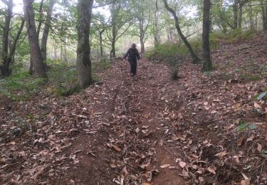
Randonnée Marche de 6,9 km à découvrir à Bretagne, Morbihan, Ploërmel. Cette randonnée est proposée par tracegps.
Description
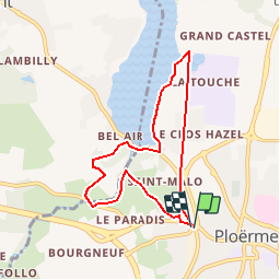
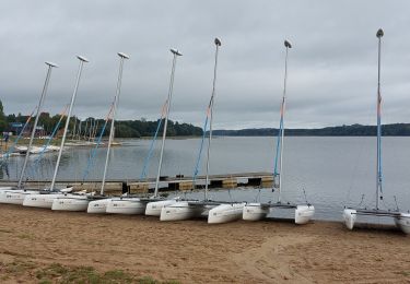
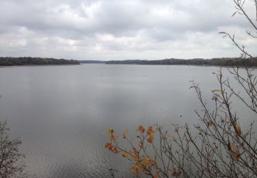
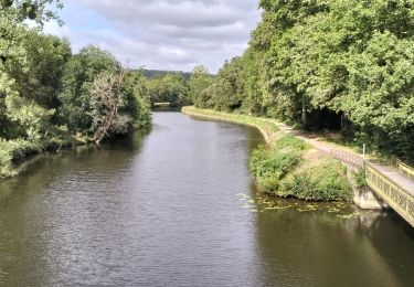
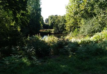
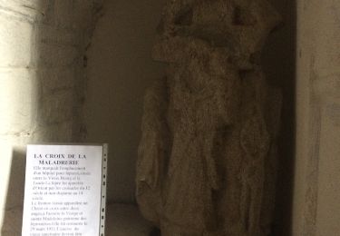
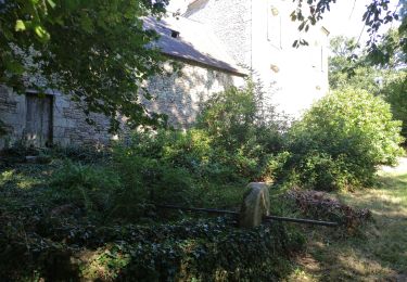
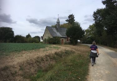
Point de départ : ancienne gare de Ploërmel - Coordonnées GPS : 02°24’24’’O / 47°56’01’’N - Distance : 7 km - 2 h 00 A voir en chemin: Hortensias boule, coniques, à fleurs plates, blanches, rouges, bleues… Plus de 5300 hydrangeas à découvrir de juin à octobre ! 1. L’église St Golven (Vieux bourg de Taupont) : église d’origine romane. A l’intérieur : retable du 17ème siècle présentant le Triomphe de la Trinité, autel en bois sculpté et doré. A l’extérieur : calvaire du 17è siècle représentant de face la crucifixion, de revers la Vierge de pitié et sur les côtés Saint Jean et Sainte Madeleine. 2. Le Lac au Duc : avec 250 ha d’étendue d’eau, il est l’un des plus grands lacs de Bretagne. Situé sur 3 communes (Ploërmel, Taupont et Loyat), le lac est un site privilégié pour les loisirs sportifs : activités nautiques, golf, tennis, pêche, équitation, roller, randonnées … 3. La voie verte (V3 Saint Malo – Rhuys) : itinéraire rêvé de balades, cette ancienne voie ferrée a été réhabilitée et aménagée pour les circulations non motorisées. Contact: Office de tourisme de Ploërmel « Terres de légendes ». Tel : 02 97 74 02 70 - Email : accueil (at) tourisme-ploermel.com
Localisation
Commentaires
Randonnées à proximité
![Randonnée Marche Taupont - GR_37_CG_41_Taupont_Josselin_20221015 - Photo](https://media.geolcdn.com/t/375/260/b059b59c-3864-4263-a6bd-503c5fbf3996.jpg&format=jpg&maxdim=2)
![Marche Marche](https://static1.geolcdn.com/sitytour/trail-icons/101.png)
Marche
![](/images/other/stat-length.png)
![](https://static1.geolcdn.com/siteimages/upload/files/16400158638029165_repeat_loop_refresh_sync_direction_icon.png)
![Randonnée Marche Ploërmel - LAC AU DUC (56) - Photo](https://media.geolcdn.com/t/375/260/ext.jpg?maxdim=2&url=https%3A%2F%2Fservices.sitytrail.com%2FGeolivesWS%2FDownloadMedia.ashx%3FTrailID%3D489578%26Media%3D20151103121400.jpg)
![Marche Marche](https://static1.geolcdn.com/sitytour/trail-icons/101.png)
Marche
![](/images/other/stat-length.png)
![](https://static1.geolcdn.com/siteimages/upload/files/16400158638029165_repeat_loop_refresh_sync_direction_icon.png)
![Randonnée V.T.T. Ploërmel - 56-ploermel_vtt_josselin_46kmD450m - Photo](https://media.geolcdn.com/t/375/260/2a918172-847e-450e-b842-62e604e2c8bf.jpg&format=jpg&maxdim=2)
![V.T.T. V.T.T.](https://static1.geolcdn.com/sitytour/trail-icons/202.png)
V.T.T.
![](/images/other/stat-length.png)
![](https://static1.geolcdn.com/siteimages/upload/files/16400158638029165_repeat_loop_refresh_sync_direction_icon.png)
![Randonnée Marche Ploërmel - la ville bouquet - Photo](https://media.geolcdn.com/t/375/260/d0ff4547-a46b-4078-8164-16d5dd8747fc.jpg&format=jpg&maxdim=2)
![Marche Marche](https://static1.geolcdn.com/sitytour/trail-icons/101.png)
Marche
![](/images/other/stat-length.png)
![](https://static1.geolcdn.com/siteimages/upload/files/16400158638029165_repeat_loop_refresh_sync_direction_icon.png)
![Randonnée Autre activité Taupont - taupins - Photo](https://media.geolcdn.com/t/375/260/ext.jpg?maxdim=2&url=https%3A%2F%2Fservices.sitytrail.com%2FGeolivesWS%2FDownloadMedia.ashx%3FTrailID%3D838567%26Media%3D20171001143518.jpg)
![Autre activité Autre activité](https://static1.geolcdn.com/sitytour/trail-icons/900.png)
Autre activité
![](/images/other/stat-length.png)
![](https://static1.geolcdn.com/siteimages/upload/files/16400158638029165_repeat_loop_refresh_sync_direction_icon.png)
![Randonnée Marche Saint-Servant - castel 2 - Photo](https://media.geolcdn.com/t/375/260/a6913563-8c20-4da5-9048-fbe8b9c47fd0.jpg&format=jpg&maxdim=2)
![Marche Marche](https://static1.geolcdn.com/sitytour/trail-icons/101.png)
![Randonnée Marche Guillac - Guillac - Photo](https://media.geolcdn.com/t/375/260/ext.jpg?maxdim=2&url=https%3A%2F%2Fstatic1.geolcdn.com%2Fsiteimages%2Fupload%2Ffiles%2F1553511878bg_sport_marche.png)
![Marche Marche](https://static1.geolcdn.com/sitytour/trail-icons/101.png)
![Randonnée Marche nordique Taupont - 2018-09-30 TAUPONT CHEMIN DES CHAPELLES - Photo](https://media.geolcdn.com/t/375/260/ext.jpg?maxdim=2&url=https%3A%2F%2Fservices.sitytrail.com%2FGeolivesWS%2FDownloadMedia.ashx%3FTrailID%3D1049033%26Media%3D20180930163130.jpg)
![Marche nordique Marche nordique](https://static1.geolcdn.com/sitytour/trail-icons/102.png)
Marche nordique
![](/images/other/stat-length.png)
![](https://static1.geolcdn.com/siteimages/upload/files/16400158638029165_repeat_loop_refresh_sync_direction_icon.png)
![Randonnée Marche Ploërmel - 2017-11-01 LA CHATOULLETTE - Photo](https://media.geolcdn.com/t/375/260/ext.jpg?maxdim=2&url=https%3A%2F%2Fservices.sitytrail.com%2FGeolivesWS%2FDownloadMedia.ashx%3FTrailID%3D855669%26Media%3D20171101155940.jpg)
![Marche Marche](https://static1.geolcdn.com/sitytour/trail-icons/101.png)
Marche
![](/images/other/stat-length.png)
![](https://static1.geolcdn.com/siteimages/upload/files/16400158638029165_repeat_loop_refresh_sync_direction_icon.png)