![](/images/other/stat-length.png)
![Randonnée Marche Mauron - Circuit du bois Ferron - Mauron - Photo](https://media.geolcdn.com/t/1900/400/ext.pjpeg?maxdim=2&url=https%3A%2F%2Fstatic1.geolcdn.com%2Fsiteimages%2Fupload%2Ffiles%2F1553511878bg_sport_marche.png)
Circuit du bois Ferron - Mauron
tracegps
Utilisateur
![Longueur](/images/other/stat-length.png)
![Altitude max](https://static1.geolcdn.com/siteimages/upload/files/1508320355ic_sort_altitude_max_24dp.png)
![Dénivelé positif](https://static1.geolcdn.com/siteimages/upload/files/1508320355ic_sort_den_pos_24dp.png)
![Km-Effort](/images/other/stat-length.png)
![Altitude min](https://static1.geolcdn.com/siteimages/upload/files/1508320355ic_sort_altitude_min_24dp.png)
![Dénivelé négatif](https://static1.geolcdn.com/siteimages/upload/files/1508320355ic_sort_den_neg_24dp.png)
![Boucle](https://static1.geolcdn.com/siteimages/upload/files/16400158638029165_repeat_loop_refresh_sync_direction_icon.png)
![Marche](https://static1.geolcdn.com/sitytour/trail-icons/101.png)
3h30
Difficulté : Moyen
![Scannez ce code QR pour ouvrir la randonnée dans l'application SityTrail](https://capi.geolives.com/qq0zvz2zws4bq2lad0pu/sitytour/trails/112510/qr.png?size=200)
Application GPS de randonnée GRATUITE
À propos
Randonnée Marche de 14,5 km à découvrir à Bretagne, Morbihan, Mauron. Cette randonnée est proposée par tracegps.
Description
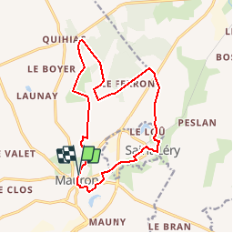
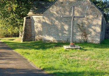
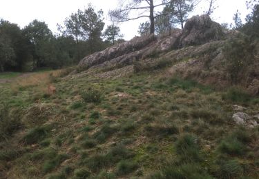
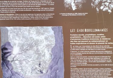
Point de départ : église de Mauron - Coordonnées GPS : 02°17’06’’O / 48°04’53’’N - Distance : 14 km - 3 h 30 A voir en chemin: 1. L’église Saint Pierre de Mauron (XVIème siècle) : les portes du portail sud sont classées Monuments Historiques. Sur les vantaux en bois, 10 scènes de l’Ancien et du Nouveau Testament : la tentation d’Adam et Eve, l’ange chasse Adam et Ève du Paradis, le meurtre d’Abel, etc… Pour préserver les vantaux, ils sont conservés à l’intérieur de l’église. Autour de l’église, plusieurs maisons du XVIIème siècle. 2. Le Bois Ferron : bois devant son nom à l'ancien château du Ferron (1747), édifié par Rolland du Noday, et rasé par la famille Martin en 1937. Il possédait jadis une chapelle privée, encore visible de nos jours. 3. L’église et la fontaine de Saint Léry (XIVème siècle) : le portail sud, orné de magnifiques sculptures est classé aux monuments historiques. Cette église aurait été construite avec des pierres du monastère détruit d’Éon de l’Etoile, religieux accusé d’hérésie. A l’intérieur, vitrail offert par Anne de Bretagne racontant son mariage avec le roi de France Charles VIII. Particularité : une horloge sans cadran dont le mécanisme est visible au fond de l’église. Dans le jardin du presbytère, la fontaine Saint Léry. Contact:Office de tourisme du pays de Mauron en Brocéliande. Tel : 02 97 93 05 12 - Email : tourisme (at) valsansretour.com
Localisation
Commentaires
Randonnées à proximité
![Randonnée Marche Mauron - GR_37_CF_40_Mauron_Taupont_20220925 - Photo](https://media.geolcdn.com/t/375/260/5934c0c6-bee8-44fc-9fe2-148a0c004337.jpg&format=jpg&maxdim=2)
![Marche Marche](https://static1.geolcdn.com/sitytour/trail-icons/101.png)
Marche
![](/images/other/stat-length.png)
![](https://static1.geolcdn.com/siteimages/upload/files/16400158638029165_repeat_loop_refresh_sync_direction_icon.png)
![Randonnée Cheval Mauron - Forêt et Pivolet - Mauron - Photo](https://media.geolcdn.com/t/375/260/ext.jpg?maxdim=2&url=https%3A%2F%2Fservices.sitytrail.com%2FGeolivesWS%2FDownloadMedia.ashx%3FTrailID%3D317519%26Media%3D16760_5.jpg)
![Cheval Cheval](https://static1.geolcdn.com/sitytour/trail-icons/300.png)
Cheval
![](/images/other/stat-length.png)
![](https://static1.geolcdn.com/siteimages/upload/files/16400158638029165_repeat_loop_refresh_sync_direction_icon.png)
![Randonnée Marche Paimpont - PAIMPONT - Photo](https://media.geolcdn.com/t/375/260/caf6292e-29eb-440a-8b85-0ee040f025a9.jpg&format=jpg&maxdim=2)
![Marche Marche](https://static1.geolcdn.com/sitytour/trail-icons/101.png)
Marche
![](/images/other/stat-length.png)
![](https://static1.geolcdn.com/siteimages/upload/files/16400158638029165_repeat_loop_refresh_sync_direction_icon.png)
![Randonnée Marche Paimpont - 2017-10-29 FONTAINE DE BARENTON BROCELIANDE - Photo](https://media.geolcdn.com/t/375/260/ext.jpg?maxdim=2&url=https%3A%2F%2Fservices.sitytrail.com%2FGeolivesWS%2FDownloadMedia.ashx%3FTrailID%3D854002%26Media%3D20171029174000.jpg)
![Marche Marche](https://static1.geolcdn.com/sitytour/trail-icons/101.png)
Marche
![](/images/other/stat-length.png)
![](https://static1.geolcdn.com/siteimages/upload/files/16400158638029165_repeat_loop_refresh_sync_direction_icon.png)
![Randonnée Marche Paimpont - Folle pensée - Photo](https://media.geolcdn.com/t/375/260/ext.jpg?maxdim=2&url=https%3A%2F%2Fstatic1.geolcdn.com%2Fsiteimages%2Fupload%2Ffiles%2F1553511878bg_sport_marche.png)
![Marche Marche](https://static1.geolcdn.com/sitytour/trail-icons/101.png)
Marche
![](/images/other/stat-length.png)
![](https://static1.geolcdn.com/siteimages/upload/files/16400158638029165_repeat_loop_refresh_sync_direction_icon.png)
![Randonnée Marche Paimpont - 35_Brocéliande_barenton_3kmD50m - Photo](https://media.geolcdn.com/t/375/260/421f34bf-43f1-4a8b-8601-9c6227c0b33c.jpg&format=jpg&maxdim=2)
![Marche Marche](https://static1.geolcdn.com/sitytour/trail-icons/101.png)
Marche
![](/images/other/stat-length.png)
![](https://static1.geolcdn.com/siteimages/upload/files/16400158638029165_repeat_loop_refresh_sync_direction_icon.png)
![Randonnée Marche Paimpont - Au pays des fées - Paimpont - Photo](https://media.geolcdn.com/t/375/260/ext.jpg?maxdim=2&url=https%3A%2F%2Fstatic1.geolcdn.com%2Fsiteimages%2Fupload%2Ffiles%2F1553511878bg_sport_marche.png)
![Marche Marche](https://static1.geolcdn.com/sitytour/trail-icons/101.png)
Marche
![](/images/other/stat-length.png)
![](https://static1.geolcdn.com/siteimages/upload/files/16400158638029165_repeat_loop_refresh_sync_direction_icon.png)
![Randonnée Marche Mauron - Circuit des fontaines - Mauron - Photo](https://media.geolcdn.com/t/375/260/ext.jpg?maxdim=2&url=https%3A%2F%2Fstatic1.geolcdn.com%2Fsiteimages%2Fupload%2Ffiles%2F1553511878bg_sport_marche.png)
![Marche Marche](https://static1.geolcdn.com/sitytour/trail-icons/101.png)
Marche
![](/images/other/stat-length.png)
![](https://static1.geolcdn.com/siteimages/upload/files/16400158638029165_repeat_loop_refresh_sync_direction_icon.png)
![Randonnée V.T.T. Néant-sur-Yvel - Vélo promenade n°20 - Circuit du bois de la Roche - Néant-sur-Yve - /Mauron - Photo](https://media.geolcdn.com/t/375/260/ext.jpg?maxdim=2&url=https%3A%2F%2Fstatic1.geolcdn.com%2Fsiteimages%2Fupload%2Ffiles%2F1524743154velo.jpg)
![V.T.T. V.T.T.](https://static1.geolcdn.com/sitytour/trail-icons/202.png)
V.T.T.
![](/images/other/stat-length.png)
![](https://static1.geolcdn.com/siteimages/upload/files/16400158638029165_repeat_loop_refresh_sync_direction_icon.png)