![](/images/other/stat-length.png)
![Randonnée Marche Monteneuf - Boucle de la voie romaine - Monteneuf - Photo](https://media.geolcdn.com/t/1900/400/ext.pjpeg?maxdim=2&url=https%3A%2F%2Fstatic1.geolcdn.com%2Fsiteimages%2Fupload%2Ffiles%2F1553511878bg_sport_marche.png)
Boucle de la voie romaine - Monteneuf
tracegps
Utilisateur
![Longueur](/images/other/stat-length.png)
![Altitude max](https://static1.geolcdn.com/siteimages/upload/files/1508320355ic_sort_altitude_max_24dp.png)
![Dénivelé positif](https://static1.geolcdn.com/siteimages/upload/files/1508320355ic_sort_den_pos_24dp.png)
![Km-Effort](/images/other/stat-length.png)
![Altitude min](https://static1.geolcdn.com/siteimages/upload/files/1508320355ic_sort_altitude_min_24dp.png)
![Dénivelé négatif](https://static1.geolcdn.com/siteimages/upload/files/1508320355ic_sort_den_neg_24dp.png)
![Boucle](https://static1.geolcdn.com/siteimages/upload/files/16400158638029165_repeat_loop_refresh_sync_direction_icon.png)
![Marche](https://static1.geolcdn.com/sitytour/trail-icons/101.png)
2h00
Difficulté : Moyen
![Scannez ce code QR pour ouvrir la randonnée dans l'application SityTrail](https://capi.geolives.com/qq0zvz2zws4bq2lad0pu/sitytour/trails/112501/qr.png?size=200)
Application GPS de randonnée GRATUITE
À propos
Randonnée Marche de 7,2 km à découvrir à Bretagne, Morbihan, Monteneuf. Cette randonnée est proposée par tracegps.
Description
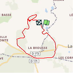
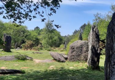
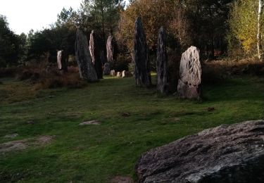
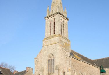
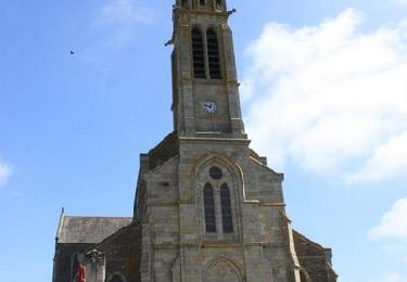
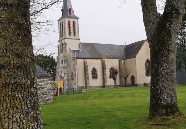
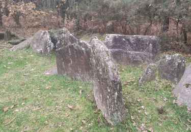
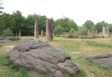
Point de départ : chapelle Saint Méen à Monteneuf (de Monteneuf, prendre la D776 direction Guer. A 500m, prendre à droite la D171 vers Carentoir. Après 4 km, tourner à gauche à l’entrée d’un bois, en direction du vilalge de Saint Méen.. Coordonnées GPS : 02°09’06’’O / 47°51’58’’N Distance : 7 km - 2 h 00 A voir en chemin : 1. La Chapelle Saint-Méen : elle fut érigée par les moines au 12ème siècle et restaurée en 1998. Saint Méen était réputé autrefois pour guérir la folie, les maladies de peau, les fièvres, les yeux à condition de se laver dans sa fontaine. 2. Le Camp des Portes : retranchement qui semble antérieur à l’époque romaine. La moitié du camp a été amputé par les terres agricoles. On y remarque toujours de grandes douves. 3. La voie romaine : reliant Angers à Carhaix, cette voie longue de 240 km semble ignorer les chefs-lieux des Civitas, ce qui signifierait que cette voie jouait un rôle stratégique et devait permettre à l’armée romaine de se déplacer rapidement. Contact Office de tourisme du Pays de Guer-Coëtquidan - 02 97 22 04 78 – email :contact (at)guer-coetquidan-tourisme.com
Localisation
Commentaires
Randonnées à proximité
![Randonnée Marche Monteneuf - PR_56_Monteneuf_AA_01_Circuit1b_Boucle-Des-Megalithes_20220508 - Photo](https://media.geolcdn.com/t/375/260/80cdb1b4-53c8-4d6d-96c2-422c67c4e04c.jpg&format=jpg&maxdim=2)
![Marche Marche](https://static1.geolcdn.com/sitytour/trail-icons/101.png)
Marche
![](/images/other/stat-length.png)
![](https://static1.geolcdn.com/siteimages/upload/files/16400158638029165_repeat_loop_refresh_sync_direction_icon.png)
![Randonnée A pied Monteneuf - La Boucle du Chaperon-Rouge - Photo](https://media.geolcdn.com/t/375/260/3270e6a7-4aba-47d6-9bf3-560c5ab3cd4e.jpeg&format=jpg&maxdim=2)
![A pied A pied](https://static1.geolcdn.com/sitytour/trail-icons/100.png)
A pied
![](/images/other/stat-length.png)
![](https://static1.geolcdn.com/siteimages/upload/files/16400158638029165_repeat_loop_refresh_sync_direction_icon.png)
![Randonnée Marche Carentoir - Quelneuc - Photo](https://media.geolcdn.com/t/375/260/d2f72121-d3ee-4078-a26b-80853263588c.jpg&format=jpg&maxdim=2)
![Marche Marche](https://static1.geolcdn.com/sitytour/trail-icons/101.png)
![Randonnée Marche Monteneuf - alignement Monteneuf - Photo](https://media.geolcdn.com/t/375/260/fc983100-b7ff-4e05-891c-98ae4da66695.jpg&format=jpg&maxdim=2)
![Marche Marche](https://static1.geolcdn.com/sitytour/trail-icons/101.png)
Marche
![](/images/other/stat-length.png)
![](https://static1.geolcdn.com/siteimages/upload/files/16400158638029165_repeat_loop_refresh_sync_direction_icon.png)
![Randonnée Vélo Carentoir - Circuit de Tréal - Carentoir - Photo](https://media.geolcdn.com/t/375/260/ext.jpg?maxdim=2&url=https%3A%2F%2Fservices.sitytrail.com%2FGeolivesWS%2FDownloadMedia.ashx%3FTrailID%3D111868%26Media%3D8684_3.jpg)
![Vélo Vélo](https://static1.geolcdn.com/sitytour/trail-icons/200.png)
Vélo
![](/images/other/stat-length.png)
![](https://static1.geolcdn.com/siteimages/upload/files/16400158638029165_repeat_loop_refresh_sync_direction_icon.png)
![Randonnée Marche Carentoir - Circuit de la Voie Ahée - Carentoir - Photo](https://media.geolcdn.com/t/375/260/ext.jpg?maxdim=2&url=https%3A%2F%2Fservices.sitytrail.com%2FGeolivesWS%2FDownloadMedia.ashx%3FTrailID%3D111761%26Media%3D8236_5.jpg)
![Marche Marche](https://static1.geolcdn.com/sitytour/trail-icons/101.png)
Marche
![](/images/other/stat-length.png)
![](https://static1.geolcdn.com/siteimages/upload/files/16400158638029165_repeat_loop_refresh_sync_direction_icon.png)
![Randonnée Marche Porcaro - 214- rando de la vallée de l'Oyon par Porcaro - Photo](https://media.geolcdn.com/t/375/260/e0e2e920-cb3d-45e1-aea1-7273d613aaf1.jpg&format=jpg&maxdim=2)
![Marche Marche](https://static1.geolcdn.com/sitytour/trail-icons/101.png)
Marche
![](/images/other/stat-length.png)
![](https://static1.geolcdn.com/siteimages/upload/files/16400158638029165_repeat_loop_refresh_sync_direction_icon.png)
![Randonnée Marche Monteneuf - monteneuf randoplo - Photo](https://media.geolcdn.com/t/375/260/d6e67f36-f1aa-4b96-a17a-fd74c27067f4.jpg&format=jpg&maxdim=2)
![Marche Marche](https://static1.geolcdn.com/sitytour/trail-icons/101.png)
Marche
![](/images/other/stat-length.png)
![](https://static1.geolcdn.com/siteimages/upload/files/16400158638029165_repeat_loop_refresh_sync_direction_icon.png)
![Randonnée A pied Monteneuf - Boucle de l'étang de Quéhéon - Photo](https://media.geolcdn.com/t/375/260/62377f27-ad71-4b92-9f68-464cfc37b4f8.jpeg&format=jpg&maxdim=2)
![A pied A pied](https://static1.geolcdn.com/sitytour/trail-icons/100.png)
A pied
![](/images/other/stat-length.png)
![](https://static1.geolcdn.com/siteimages/upload/files/16400158638029165_repeat_loop_refresh_sync_direction_icon.png)