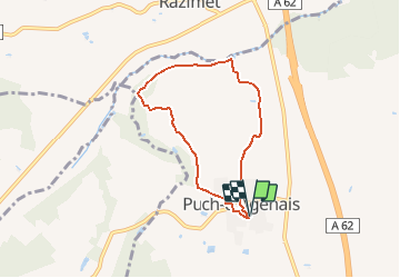
![](/images/other/stat-length.png)
![Randonnée V.T.T. Puch-d'Agenais - Puch-d'Agenais, dans les terrasses de Garonne - Pays de la vallée du Lot - Photo](https://media.geolcdn.com/t/1900/400/ext.pjpeg?maxdim=2&url=https%3A%2F%2Fservices.sitytrail.com%2FGeolivesWS%2FDownloadMedia.ashx%3FTrailID%3D112391%26Media%3D10516_1.jpg)
Puch-d'Agenais, dans les terrasses de Garonne - Pays de la vallée du Lot
tracegps
Utilisateur
![Longueur](/images/other/stat-length.png)
![Altitude max](https://static1.geolcdn.com/siteimages/upload/files/1508320355ic_sort_altitude_max_24dp.png)
![Dénivelé positif](https://static1.geolcdn.com/siteimages/upload/files/1508320355ic_sort_den_pos_24dp.png)
![Km-Effort](/images/other/stat-length.png)
![Altitude min](https://static1.geolcdn.com/siteimages/upload/files/1508320355ic_sort_altitude_min_24dp.png)
![Dénivelé négatif](https://static1.geolcdn.com/siteimages/upload/files/1508320355ic_sort_den_neg_24dp.png)
![Boucle](https://static1.geolcdn.com/siteimages/upload/files/16400158638029165_repeat_loop_refresh_sync_direction_icon.png)
![V.T.T.](https://static1.geolcdn.com/sitytour/trail-icons/202.png)
30m
Difficulté : Facile
![Scannez ce code QR pour ouvrir la randonnée dans l'application SityTrail](https://capi.geolives.com/qq0zvz2zws4bq2lad0pu/sitytour/trails/112391/qr.png?size=200)
Application GPS de randonnée GRATUITE
À propos
Randonnée V.T.T. de 6,1 km à découvrir à Nouvelle-Aquitaine, Lot-et-Garonne, Puch-d'Agenais. Cette randonnée est proposée par tracegps.
Description
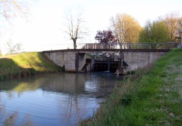
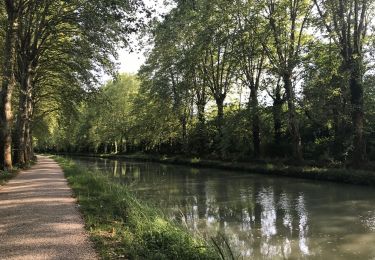
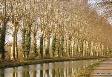
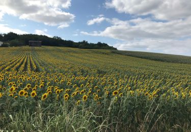
Puch-d’Agenais, dans les terrasses de Garonne - Pays de la vallée du Lot. Puch signifie « petite éminence ». De là s’observent les paysages de la vallée et des coteaux de la Garonne. Le vert domine : tabac, maïs, prairies d’élevage et bois sur les fortes pentes. Téléchargez la fiche de cette randonnée sur le site du Tourisme du Lot et Garonne. Le petit blond lot-et-garonnais : Au 17ème siècle, le Chevalier de Vivens qui introduit le tabac à Clairac ne pouvait imaginer que « l’herbe à Nicot » ferait partie du paysage lot-et-garonnais. Le cadastre napoléonien et ses matrices 19ème nous apprennent qu’il était déjà largement cultivé au siècle. Le tabac brun s’adaptait particulièrement bien aux exploitations en polyculture. On le récoltait plante entière fin août. Il séchait à l’air naturel dans des séchoirs de bois, nombreux encore aujourd’hui dans nos campagnes. Il était ensuite effeuillé et trié. Depuis 1976, le tabac blond, Virginie et Burley, l’a progressivement remplacé. En crise aujourd’hui, il représente toujours une part importante du revenu des agriculteurs et de nombreux emplois dans les manufactures et entreprises liées à sa production.
Localisation
Commentaires
Randonnées à proximité
![Randonnée A pied Puch-d'Agenais - Puch-d’Agenais, dans les terrasses de Garonne - 6.2km - Photo](https://media.geolcdn.com/t/375/260/dc9518d9-efab-4e90-9485-f22707f891a4.jpeg&format=jpg&maxdim=2)
![A pied A pied](https://static1.geolcdn.com/sitytour/trail-icons/100.png)
A pied
![](/images/other/stat-length.png)
![](https://static1.geolcdn.com/siteimages/upload/files/16400158638029165_repeat_loop_refresh_sync_direction_icon.png)
![Randonnée A pied Villefranche-du-Queyran - Villefranche, la bastide du Queyran - 15.2 km - Photo](https://media.geolcdn.com/t/375/260/cd42762c-a44d-48c9-bf4c-2fec67607de6.jpeg&format=jpg&maxdim=2)
![A pied A pied](https://static1.geolcdn.com/sitytour/trail-icons/100.png)
A pied
![](/images/other/stat-length.png)
![](https://static1.geolcdn.com/siteimages/upload/files/16400158638029165_repeat_loop_refresh_sync_direction_icon.png)
![Randonnée A pied Puch-d'Agenais - Damazan, la Bastide du Canal de Garonne - 9,8km - Photo](https://media.geolcdn.com/t/375/260/955b4ae8-ce27-4a8a-bfc0-015d1284cb45.jpeg&format=jpg&maxdim=2)
![A pied A pied](https://static1.geolcdn.com/sitytour/trail-icons/100.png)
A pied
![](/images/other/stat-length.png)
![](https://static1.geolcdn.com/siteimages/upload/files/16400158638029165_repeat_loop_refresh_sync_direction_icon.png)
![Randonnée V.T.C. Damazan - Canal de la Garonne - Photo](https://media.geolcdn.com/t/375/260/25c5747e-6a5a-4905-a2f9-2d790cfee421.jpg&format=jpg&maxdim=2)
![V.T.C. V.T.C.](https://static1.geolcdn.com/sitytour/trail-icons/203.png)
V.T.C.
![](/images/other/stat-length.png)
![](https://static1.geolcdn.com/siteimages/upload/files/16400158638029165_repeat_loop_refresh_sync_direction_icon.png)
![Randonnée Vélo Anzex - Canal Garonne de casteljaloux à Castelssarasin - Photo](https://media.geolcdn.com/t/375/260/ext.jpg?maxdim=2&url=https%3A%2F%2Fservices.sitytrail.com%2FGeolivesWS%2FDownloadMedia.ashx%3FTrailID%3D450847%26Media%3De4da941b-6bcd-4c59-a11e-3f964c770e5a.JPG)
![Vélo Vélo](https://static1.geolcdn.com/sitytour/trail-icons/200.png)
Vélo
![](/images/other/stat-length.png)
![](https://static1.geolcdn.com/siteimages/upload/files/16400158638029165_repeat_loop_refresh_sync_direction_icon.png)
![Randonnée V.T.T. Damazan - La bastide du Canal de Garonne - Damazan - Photo](https://media.geolcdn.com/t/375/260/ext.jpg?maxdim=2&url=https%3A%2F%2Fservices.sitytrail.com%2FGeolivesWS%2FDownloadMedia.ashx%3FTrailID%3D318079%26Media%3D17544_3.jpg)
![V.T.T. V.T.T.](https://static1.geolcdn.com/sitytour/trail-icons/202.png)
V.T.T.
![](/images/other/stat-length.png)
![](https://static1.geolcdn.com/siteimages/upload/files/16400158638029165_repeat_loop_refresh_sync_direction_icon.png)
![Randonnée Marche Damazan - La bastide du Canal de Garonne - Damazan - Photo](https://media.geolcdn.com/t/375/260/ext.jpg?maxdim=2&url=https%3A%2F%2Fservices.sitytrail.com%2FGeolivesWS%2FDownloadMedia.ashx%3FTrailID%3D318078%26Media%3D17544_5.jpg)
![Marche Marche](https://static1.geolcdn.com/sitytour/trail-icons/101.png)
Marche
![](/images/other/stat-length.png)
![](https://static1.geolcdn.com/siteimages/upload/files/16400158638029165_repeat_loop_refresh_sync_direction_icon.png)
![Randonnée A pied Monheurt - Monheurt, balade entre Garonne et canal - 7 km - Photo](https://media.geolcdn.com/t/375/260/ext.jpg?maxdim=2&url=https%3A%2F%2Fstatic1.geolcdn.com%2Fsiteimages%2Fupload%2Ffiles%2F1545311037marcheuse_200dpi.jpg)
![A pied A pied](https://static1.geolcdn.com/sitytour/trail-icons/100.png)
A pied
![](/images/other/stat-length.png)
![](https://static1.geolcdn.com/siteimages/upload/files/16400158638029165_repeat_loop_refresh_sync_direction_icon.png)
![Randonnée V.T.C. Damazan - Damazan Caubeyres - Photo](https://media.geolcdn.com/t/375/260/728b4b2a-058a-43b5-bc3d-2ba49ed1b942.jpg&format=jpg&maxdim=2)
![V.T.C. V.T.C.](https://static1.geolcdn.com/sitytour/trail-icons/203.png)
V.T.C.
![](/images/other/stat-length.png)
![](https://static1.geolcdn.com/siteimages/upload/files/16400158638029165_repeat_loop_refresh_sync_direction_icon.png)