![](/images/other/stat-length.png)
![Randonnée V.T.T. Saint-Cirgues-la-Loutre - Le Gourdaloup 12 km - Saint Cirgues la Loutre - Pays de la Vallée de la Dordogne Corrézienne - Photo](https://media.geolcdn.com/t/1900/400/ext.pjpeg?maxdim=2&url=https%3A%2F%2Fservices.sitytrail.com%2FGeolivesWS%2FDownloadMedia.ashx%3FTrailID%3D112299%26Media%3D10305_1.jpg)
Le Gourdaloup 12 km - Saint Cirgues la Loutre - Pays de la Vallée de la Dordogne Corrézienne
tracegps
Utilisateur
![Longueur](/images/other/stat-length.png)
![Altitude max](https://static1.geolcdn.com/siteimages/upload/files/1508320355ic_sort_altitude_max_24dp.png)
![Dénivelé positif](https://static1.geolcdn.com/siteimages/upload/files/1508320355ic_sort_den_pos_24dp.png)
![Km-Effort](/images/other/stat-length.png)
![Altitude min](https://static1.geolcdn.com/siteimages/upload/files/1508320355ic_sort_altitude_min_24dp.png)
![Dénivelé négatif](https://static1.geolcdn.com/siteimages/upload/files/1508320355ic_sort_den_neg_24dp.png)
![Boucle](https://static1.geolcdn.com/siteimages/upload/files/16400158638029165_repeat_loop_refresh_sync_direction_icon.png)
![V.T.T.](https://static1.geolcdn.com/sitytour/trail-icons/202.png)
1h00
Difficulté : Moyen
![Scannez ce code QR pour ouvrir la randonnée dans l'application SityTrail](https://capi.geolives.com/qq0zvz2zws4bq2lad0pu/sitytour/trails/112299/qr.png?size=200)
Application GPS de randonnée GRATUITE
À propos
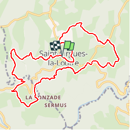
Randonnée V.T.T. de 11,9 km à découvrir à Nouvelle-Aquitaine, Corrèze, Saint-Cirgues-la-Loutre. Cette randonnée est proposée par tracegps.
Description
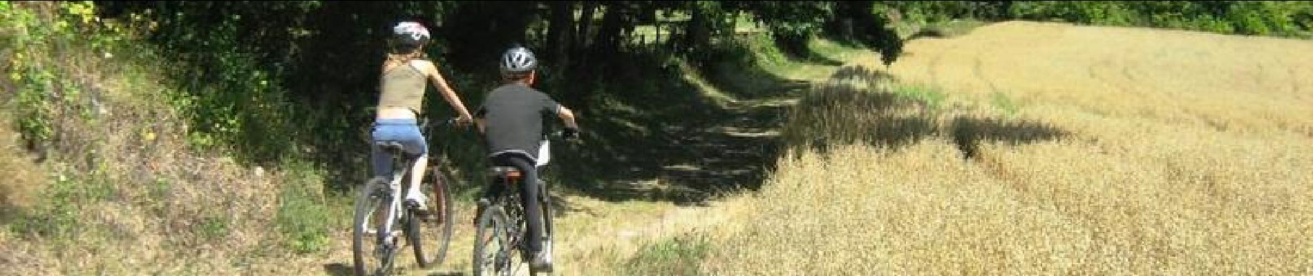
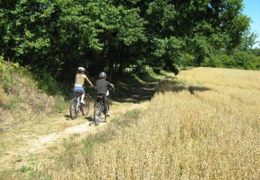
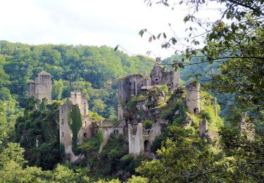
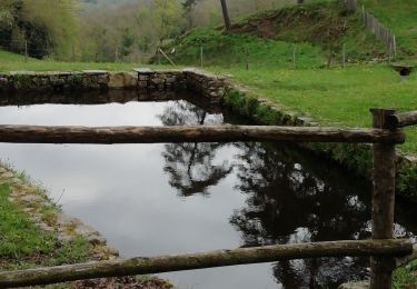
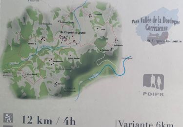
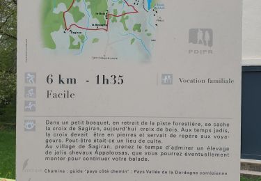
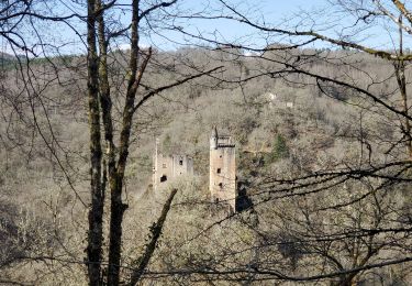
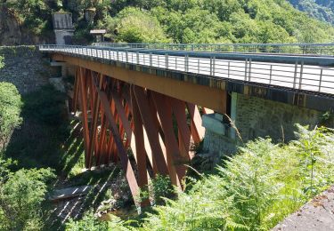
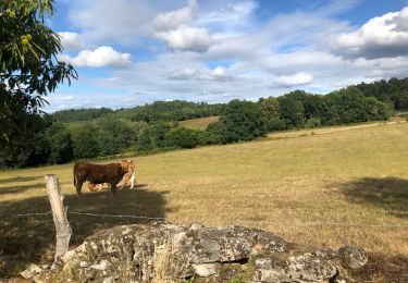
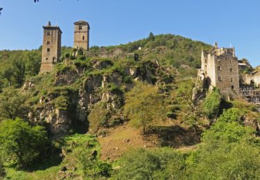
Le Gourdaloup 12 km - Saint Cirgues la Loutre - Pays de la Vallée de la Dordogne Corrézienne. Au cœur de la Xaintrie Blanche, ce long circuit, qui peut être réduit de moitié alterne des petites routes et des chemins faciles, très roulant à V.T.T. Multipliant les points de vue sur le ruisseau du Gourdaloup, les gorges de la Maronne, le bourg de SAINT-CIRGUES-LA-LOUTRE (son église et sa légende), les tours de Carbonnières, les Tours de Merle, le Château du Rieu, il traverse le vieux bourg de Saint Geniez ô Merle. En traversant les villages vous remarquerez les maisons de Xaintrie, des puits, une source, un four à pain Téléchargez la fiche du circuit sur le site du Conseil Général de la Corrèze. Renseignements : Mairie de St Cirgues la Loutre 05.55.28.27.04
Localisation
Commentaires
Randonnées à proximité
![Randonnée Marche Saint-Cirgues-la-Loutre - Le Gourdaloup 6 km - Saint Cirgues la Loutre - Pays de la Vallée de la Dordogne Corrézienne - Photo](https://media.geolcdn.com/t/375/260/ext.jpg?maxdim=2&url=https%3A%2F%2Fservices.sitytrail.com%2FGeolivesWS%2FDownloadMedia.ashx%3FTrailID%3D112330%26Media%3D10360_1.jpg)
![Marche Marche](https://static1.geolcdn.com/sitytour/trail-icons/101.png)
Marche
![](/images/other/stat-length.png)
![](https://static1.geolcdn.com/siteimages/upload/files/16400158638029165_repeat_loop_refresh_sync_direction_icon.png)
![Randonnée Marche Saint-Cirgues-la-Loutre - Les Tours de Merlé - Saint Cirgues la Loutre - Photo](https://media.geolcdn.com/t/375/260/ext.jpg?maxdim=2&url=https%3A%2F%2Fservices.sitytrail.com%2FGeolivesWS%2FDownloadMedia.ashx%3FTrailID%3D106306%26Media%3D10691_1.jpg)
![Marche Marche](https://static1.geolcdn.com/sitytour/trail-icons/101.png)
Marche
![](/images/other/stat-length.png)
![](https://static1.geolcdn.com/siteimages/upload/files/16400158638029165_repeat_loop_refresh_sync_direction_icon.png)
![Randonnée Marche Goulles - Fred BC GOULLES - Photo](https://media.geolcdn.com/t/375/260/e8141b16-10db-4c81-af02-a30b2efafbbf.jpg&format=jpg&maxdim=2)
![Marche Marche](https://static1.geolcdn.com/sitytour/trail-icons/101.png)
Marche
![](/images/other/stat-length.png)
![](https://static1.geolcdn.com/siteimages/upload/files/16400158638029165_repeat_loop_refresh_sync_direction_icon.png)
![Randonnée Marche Saint-Cirgues-la-Loutre - le Gourdaloup - Photo](https://media.geolcdn.com/t/375/260/32c17a79-c1ba-4c25-a7e6-d0d33eb021a6.jpg&format=jpg&maxdim=2)
![Marche Marche](https://static1.geolcdn.com/sitytour/trail-icons/101.png)
Marche
![](/images/other/stat-length.png)
![](https://static1.geolcdn.com/siteimages/upload/files/16400158638029165_repeat_loop_refresh_sync_direction_icon.png)
![Randonnée Marche Saint-Julien-aux-Bois - Croix de Sagiran - Photo](https://media.geolcdn.com/t/375/260/1a371f0d-5b0a-4f26-a8f1-d42b6e1251d5.jpg&format=jpg&maxdim=2)
![Marche Marche](https://static1.geolcdn.com/sitytour/trail-icons/101.png)
Marche
![](/images/other/stat-length.png)
![](https://static1.geolcdn.com/siteimages/upload/files/16400158638029165_repeat_loop_refresh_sync_direction_icon.png)
![Randonnée Marche Goulles - Les tours Carbonnieres - Photo](https://media.geolcdn.com/t/375/260/90a7e5fb-b218-42bd-a403-ae58cfbb4d41.jpg&format=jpg&maxdim=2)
![Marche Marche](https://static1.geolcdn.com/sitytour/trail-icons/101.png)
Marche
![](/images/other/stat-length.png)
![](https://static1.geolcdn.com/siteimages/upload/files/16400158638029165_repeat_loop_refresh_sync_direction_icon.png)
![Randonnée Marche Saint-Geniez-ô-Merle - 20210615 Tours de Merle - Photo](https://media.geolcdn.com/t/375/260/6024fabf-7fcc-4d15-853b-ddcf0aa5120e.jpg&format=jpg&maxdim=2)
![Marche Marche](https://static1.geolcdn.com/sitytour/trail-icons/101.png)
Marche
![](/images/other/stat-length.png)
![](https://static1.geolcdn.com/siteimages/upload/files/16400158638029165_repeat_loop_refresh_sync_direction_icon.png)
![Randonnée Marche Saint-Privat - Malesse - tours de Merle - Photo](https://media.geolcdn.com/t/375/260/cf29b99a-6a16-4068-860b-c6da043e231f.jpg&format=jpg&maxdim=2)
![Marche Marche](https://static1.geolcdn.com/sitytour/trail-icons/101.png)
Marche
![](/images/other/stat-length.png)
![](https://static1.geolcdn.com/siteimages/upload/files/16400158638029165_repeat_loop_refresh_sync_direction_icon.png)
![Randonnée Marche Saint-Geniez-ô-Merle - Les tours de Merle - Photo](https://media.geolcdn.com/t/375/260/ext.jpg?maxdim=2&url=https%3A%2F%2Fservices.sitytrail.com%2FGeolivesWS%2FDownloadMedia.ashx%3FTrailID%3D705307%26Media%3D9368312f-2f0c-4c6e-b94a-95b4492775b0.JPG)
![Marche Marche](https://static1.geolcdn.com/sitytour/trail-icons/101.png)
Marche
![](/images/other/stat-length.png)
![](https://static1.geolcdn.com/siteimages/upload/files/16400158638029165_repeat_loop_refresh_sync_direction_icon.png)