![](/images/other/stat-length.png)
![Randonnée Marche Pihen-lès-Guînes - Sentier des crêtes - Pihen-les-Guînes - Photo](https://media.geolcdn.com/t/1900/400/ext.pjpeg?maxdim=2&url=https%3A%2F%2Fservices.sitytrail.com%2FGeolivesWS%2FDownloadMedia.ashx%3FTrailID%3D111903%26Media%3D8906_6.jpg)
Sentier des crêtes - Pihen-les-Guînes
tracegps
Utilisateur
![Longueur](/images/other/stat-length.png)
Longueur
8,2 km
![Altitude max](https://static1.geolcdn.com/siteimages/upload/files/1508320355ic_sort_altitude_max_24dp.png)
Altitude max
82 m
![Dénivelé positif](https://static1.geolcdn.com/siteimages/upload/files/1508320355ic_sort_den_pos_24dp.png)
Dénivelé positif
88 m
![Km-Effort](/images/other/stat-length.png)
Km-Effort
9,4 km
![Altitude min](https://static1.geolcdn.com/siteimages/upload/files/1508320355ic_sort_altitude_min_24dp.png)
Altitude min
26 m
![Dénivelé négatif](https://static1.geolcdn.com/siteimages/upload/files/1508320355ic_sort_den_neg_24dp.png)
Dénivelé négatif
87 m
![Boucle](https://static1.geolcdn.com/siteimages/upload/files/16400158638029165_repeat_loop_refresh_sync_direction_icon.png)
Boucle
Oui
Date de création :
2014-12-10 00:00:00.0
Dernière modification :
2014-12-10 00:00:00.0
![Marche](https://static1.geolcdn.com/sitytour/trail-icons/101.png)
2h04
Difficulté : Moyen
![Scannez ce code QR pour ouvrir la randonnée dans l'application SityTrail](https://capi.geolives.com/qq0zvz2zws4bq2lad0pu/sitytour/trails/111903/qr.png?size=200)
Application GPS de randonnée GRATUITE
À propos
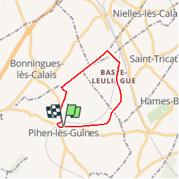
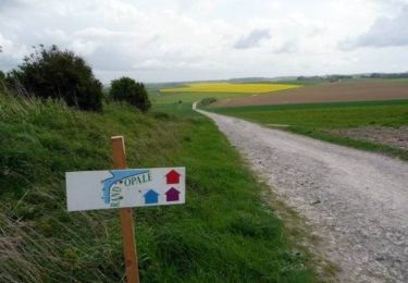
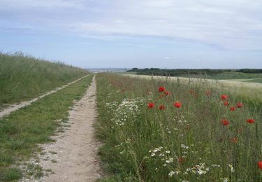
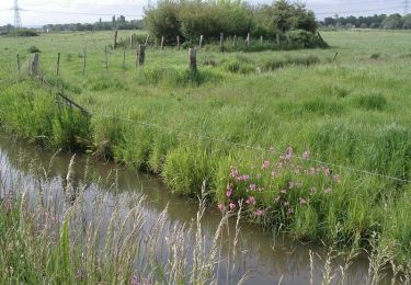
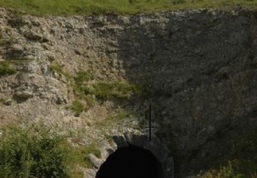
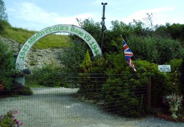
Randonnée Marche de 8,2 km à découvrir à Hauts-de-France, Pas-de-Calais, Pihen-lès-Guînes. Cette randonnée est proposée par tracegps.
Description
Circuit proposé par la communauté de communes du Sud-Ouest du Calaisis. Départ de la mairie de Pihen-les-Guines. Ce circuit a été numérisé par les randonneurs du CODEPEM.
Localisation
Pays :
France
Région :
Hauts-de-France
Département/Province :
Pas-de-Calais
Commune :
Pihen-lès-Guînes
Localité :
Unknown
Départ:(Dec)
Départ:(UTM)
414685 ; 5636314 (31U) N.
Commentaires
Randonnées à proximité
![Randonnée Marche Caffiers - Les Croisettes - Caffiers - Photo](https://media.geolcdn.com/t/375/260/ext.jpg?maxdim=2&url=https%3A%2F%2Fservices.sitytrail.com%2FGeolivesWS%2FDownloadMedia.ashx%3FTrailID%3D112081%26Media%3D9761_4.jpg)
![Marche Marche](https://static1.geolcdn.com/sitytour/trail-icons/101.png)
Les Croisettes - Caffiers
Marche
Moyen
(4)
Caffiers,
Hauts-de-France,
Pas-de-Calais,
France
![](/images/other/stat-length.png)
10,7 km | 12,7 km-effort
2h 40min
![](https://static1.geolcdn.com/siteimages/upload/files/16400158638029165_repeat_loop_refresh_sync_direction_icon.png)
Oui
![Randonnée Marche Escalles - ⛺️ Les Érables - Cap Blanc-Nez - Photo](https://media.geolcdn.com/t/375/260/4ecc3ab4-bceb-4584-bd93-230747ad2605.jpg&format=jpg&maxdim=2)
![Marche Marche](https://static1.geolcdn.com/sitytour/trail-icons/101.png)
⛺️ Les Érables - Cap Blanc-Nez
Marche
Moyen
Escalles,
Hauts-de-France,
Pas-de-Calais,
France
![](/images/other/stat-length.png)
6,9 km | 9,3 km-effort
1h 53min
![](https://static1.geolcdn.com/siteimages/upload/files/16400158638029165_repeat_loop_refresh_sync_direction_icon.png)
Oui
![Randonnée V.T.T. Leubringhen - Terre des deux caps variante VTT 2 - Photo](https://media.geolcdn.com/t/375/260/ext.jpg?maxdim=2&url=https%3A%2F%2Fstatic1.geolcdn.com%2Fsiteimages%2Fupload%2Ffiles%2F1524743154velo.jpg)
![V.T.T. V.T.T.](https://static1.geolcdn.com/sitytour/trail-icons/202.png)
Terre des deux caps variante VTT 2
V.T.T.
Moyen
(1)
Leubringhen,
Hauts-de-France,
Pas-de-Calais,
France
![](/images/other/stat-length.png)
36 km | 42 km-effort
2h 50min
![](https://static1.geolcdn.com/siteimages/upload/files/16400158638029165_repeat_loop_refresh_sync_direction_icon.png)
Oui
![Randonnée Marche Bonningues-lès-Calais - Chemin de la Folie - Bonningues-les-Calais - Photo](https://media.geolcdn.com/t/375/260/ext.jpg?maxdim=2&url=https%3A%2F%2Fservices.sitytrail.com%2FGeolivesWS%2FDownloadMedia.ashx%3FTrailID%3D110304%26Media%3D5728_3.jpg)
![Marche Marche](https://static1.geolcdn.com/sitytour/trail-icons/101.png)
Chemin de la Folie - Bonningues-les-Calais
Marche
Moyen
Bonningues-lès-Calais,
Hauts-de-France,
Pas-de-Calais,
France
![](/images/other/stat-length.png)
9,8 km | 11,5 km-effort
2h 30min
![](https://static1.geolcdn.com/siteimages/upload/files/16400158638029165_repeat_loop_refresh_sync_direction_icon.png)
Oui
![Randonnée Marche Peuplingues - Sentier des fonds - Peuplingues - Photo](https://media.geolcdn.com/t/375/260/ext.jpg?maxdim=2&url=https%3A%2F%2Fservices.sitytrail.com%2FGeolivesWS%2FDownloadMedia.ashx%3FTrailID%3D110293%26Media%3D5691_6.jpg)
![Marche Marche](https://static1.geolcdn.com/sitytour/trail-icons/101.png)
Sentier des fonds - Peuplingues
Marche
Moyen
(1)
Peuplingues,
Hauts-de-France,
Pas-de-Calais,
France
![](/images/other/stat-length.png)
11,2 km | 13,3 km-effort
2h 49min
![](https://static1.geolcdn.com/siteimages/upload/files/16400158638029165_repeat_loop_refresh_sync_direction_icon.png)
Oui
![Randonnée Marche Saint-Tricat - La boucle des marais - St Tricat - Photo](https://media.geolcdn.com/t/375/260/ext.jpg?maxdim=2&url=https%3A%2F%2Fservices.sitytrail.com%2FGeolivesWS%2FDownloadMedia.ashx%3FTrailID%3D110279%26Media%3D5673_6.jpg)
![Marche Marche](https://static1.geolcdn.com/sitytour/trail-icons/101.png)
La boucle des marais - St Tricat
Marche
Moyen
Saint-Tricat,
Hauts-de-France,
Pas-de-Calais,
France
![](/images/other/stat-length.png)
10,5 km | 11,3 km-effort
2h 40min
![](https://static1.geolcdn.com/siteimages/upload/files/16400158638029165_repeat_loop_refresh_sync_direction_icon.png)
Oui
![Randonnée Marche Landrethun-le-Nord - Balade des Poissonniers. (Landrethun le Nord) - Photo](https://media.geolcdn.com/t/375/260/ext.jpg?maxdim=2&url=https%3A%2F%2Fservices.sitytrail.com%2FGeolivesWS%2FDownloadMedia.ashx%3FTrailID%3D109984%26Media%3D5069_4.jpg)
![Marche Marche](https://static1.geolcdn.com/sitytour/trail-icons/101.png)
Balade des Poissonniers. (Landrethun le Nord)
Marche
Moyen
Landrethun-le-Nord,
Hauts-de-France,
Pas-de-Calais,
France
![](/images/other/stat-length.png)
11,1 km | 13 km-effort
2h 45min
![](https://static1.geolcdn.com/siteimages/upload/files/16400158638029165_repeat_loop_refresh_sync_direction_icon.png)
Oui
![Randonnée Marche Escalles - D'un Cap à l'autre - Photo](https://media.geolcdn.com/t/375/260/ext.jpg?maxdim=2&url=https%3A%2F%2Fstatic1.geolcdn.com%2Fsiteimages%2Fupload%2Ffiles%2F1553511878bg_sport_marche.png)
![Marche Marche](https://static1.geolcdn.com/sitytour/trail-icons/101.png)
D'un Cap à l'autre
Marche
Moyen
Escalles,
Hauts-de-France,
Pas-de-Calais,
France
![](/images/other/stat-length.png)
12,5 km | 14,3 km-effort
3h 14min
![](https://static1.geolcdn.com/siteimages/upload/files/16400158638029165_repeat_loop_refresh_sync_direction_icon.png)
Non
![Randonnée A pied Landrethun-le-Nord - Sentiers des Poissonniers - Photo](https://media.geolcdn.com/t/375/260/53724d4e-7c77-42a5-9380-d311f217794e.jpeg&format=jpg&maxdim=2)
![A pied A pied](https://static1.geolcdn.com/sitytour/trail-icons/100.png)
Sentiers des Poissonniers
A pied
Facile
Landrethun-le-Nord,
Hauts-de-France,
Pas-de-Calais,
France
![](/images/other/stat-length.png)
9,4 km | 11,2 km-effort
2h 33min
![](https://static1.geolcdn.com/siteimages/upload/files/16400158638029165_repeat_loop_refresh_sync_direction_icon.png)
Non