![](/images/other/stat-length.png)
![Randonnée Marche Sainte-Marie - Circuit des Ardoisières - Sainte Marie - Photo](https://media.geolcdn.com/t/1900/400/ext.pjpeg?maxdim=2&url=https%3A%2F%2Fservices.sitytrail.com%2FGeolivesWS%2FDownloadMedia.ashx%3FTrailID%3D111778%26Media%3D8285_4.jpg)
Circuit des Ardoisières - Sainte Marie
tracegps
Utilisateur
![Longueur](/images/other/stat-length.png)
Longueur
11,2 km
![Altitude max](https://static1.geolcdn.com/siteimages/upload/files/1508320355ic_sort_altitude_max_24dp.png)
Altitude max
45 m
![Dénivelé positif](https://static1.geolcdn.com/siteimages/upload/files/1508320355ic_sort_den_pos_24dp.png)
Dénivelé positif
119 m
![Km-Effort](/images/other/stat-length.png)
Km-Effort
12,8 km
![Altitude min](https://static1.geolcdn.com/siteimages/upload/files/1508320355ic_sort_altitude_min_24dp.png)
Altitude min
2 m
![Dénivelé négatif](https://static1.geolcdn.com/siteimages/upload/files/1508320355ic_sort_den_neg_24dp.png)
Dénivelé négatif
121 m
![Boucle](https://static1.geolcdn.com/siteimages/upload/files/16400158638029165_repeat_loop_refresh_sync_direction_icon.png)
Boucle
Oui
Date de création :
2014-12-10 00:00:00.0
Dernière modification :
2014-12-10 00:00:00.0
![Marche](https://static1.geolcdn.com/sitytour/trail-icons/101.png)
2h45
Difficulté : Moyen
![Scannez ce code QR pour ouvrir la randonnée dans l'application SityTrail](https://capi.geolives.com/qq0zvz2zws4bq2lad0pu/sitytour/trails/111778/qr.png?size=200)
Application GPS de randonnée GRATUITE
À propos
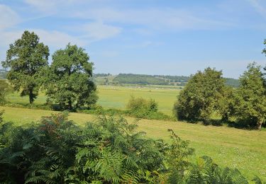
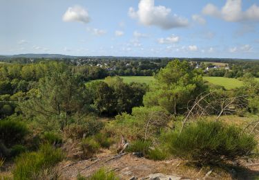
Randonnée Marche de 11,2 km à découvrir à Bretagne, Ille-et-Vilaine, Sainte-Marie. Cette randonnée est proposée par tracegps.
Description
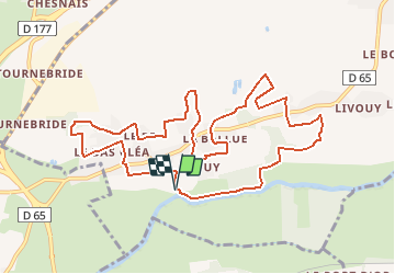
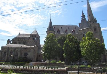
Circuit proposé par la maison du tourisme du Pays de Redon. Départ de la halte nautique du Pont du grand-Pas à Sainte-Marie. Retrouvez le plan et le descriptif sur le site de la maison du tourisme du Pays de Redon
Localisation
Pays :
France
Région :
Bretagne
Département/Province :
Ille-et-Vilaine
Commune :
Sainte-Marie
Localité :
Unknown
Départ:(Dec)
Départ:(UTM)
572414 ; 5280378 (30T) N.
Commentaires
Randonnées à proximité
![Randonnée A pied Sainte-Marie - Les Ardoisières - Photo](https://media.geolcdn.com/t/375/260/bd0bc078-ecb9-4ba1-88a5-43d278ab6879.jpeg&format=jpg&maxdim=2)
![A pied A pied](https://static1.geolcdn.com/sitytour/trail-icons/100.png)
Les Ardoisières
A pied
Facile
Sainte-Marie,
Bretagne,
Ille-et-Vilaine,
France
![](/images/other/stat-length.png)
14,3 km | 16,3 km-effort
3h 42min
![](https://static1.geolcdn.com/siteimages/upload/files/16400158638029165_repeat_loop_refresh_sync_direction_icon.png)
Oui
![Randonnée V.T.C. Redon - Redon Héric Jour 5 - Photo](https://media.geolcdn.com/t/375/260/a67d4a59-a0ad-40cb-bce3-092e3619fcf7.jpg&format=jpg&maxdim=2)
![V.T.C. V.T.C.](https://static1.geolcdn.com/sitytour/trail-icons/203.png)
Redon Héric Jour 5
V.T.C.
Facile
Redon,
Bretagne,
Ille-et-Vilaine,
France
![](/images/other/stat-length.png)
65 km | 71 km-effort
3h 19min
![](https://static1.geolcdn.com/siteimages/upload/files/16400158638029165_repeat_loop_refresh_sync_direction_icon.png)
Non
![Randonnée V.T.C. Redon - Etape 1 - Redon/Josselin - Photo](https://media.geolcdn.com/t/375/260/ext.jpg?maxdim=2&url=https%3A%2F%2Fstatic1.geolcdn.com%2Fsiteimages%2Fupload%2Ffiles%2F1524743154velo.jpg)
![V.T.C. V.T.C.](https://static1.geolcdn.com/sitytour/trail-icons/203.png)
Etape 1 - Redon/Josselin
V.T.C.
Difficile
(1)
Redon,
Bretagne,
Ille-et-Vilaine,
France
![](/images/other/stat-length.png)
68 km | 74 km-effort
Inconnu
![](https://static1.geolcdn.com/siteimages/upload/files/16400158638029165_repeat_loop_refresh_sync_direction_icon.png)
Non
![Randonnée Cheval Redon - La Vallée de l'Oust - Redon - Photo](https://media.geolcdn.com/t/375/260/ext.jpg?maxdim=2&url=https%3A%2F%2Fservices.sitytrail.com%2FGeolivesWS%2FDownloadMedia.ashx%3FTrailID%3D317600%26Media%3D16868_5.jpg)
![Cheval Cheval](https://static1.geolcdn.com/sitytour/trail-icons/300.png)
La Vallée de l'Oust - Redon
Cheval
Moyen
Redon,
Bretagne,
Ille-et-Vilaine,
France
![](/images/other/stat-length.png)
16 km | 18,4 km-effort
2h 0min
![](https://static1.geolcdn.com/siteimages/upload/files/16400158638029165_repeat_loop_refresh_sync_direction_icon.png)
Non
![Randonnée Marche Redon - De la Belle Anguille au bois de Bahurel - Redon - Photo](https://media.geolcdn.com/t/375/260/ext.jpg?maxdim=2&url=https%3A%2F%2Fservices.sitytrail.com%2FGeolivesWS%2FDownloadMedia.ashx%3FTrailID%3D317496%26Media%3D16731_4.jpg)
![Marche Marche](https://static1.geolcdn.com/sitytour/trail-icons/101.png)
De la Belle Anguille au bois de Bahurel - Redon
Marche
Difficile
Redon,
Bretagne,
Ille-et-Vilaine,
France
![](/images/other/stat-length.png)
14,6 km | 17,1 km-effort
3h 45min
![](https://static1.geolcdn.com/siteimages/upload/files/16400158638029165_repeat_loop_refresh_sync_direction_icon.png)
Oui
![Randonnée Marche Avessac - Circuit des Saletin (10,5 km) - Avessac - Photo](https://media.geolcdn.com/t/375/260/ext.jpg?maxdim=2&url=https%3A%2F%2Fservices.sitytrail.com%2FGeolivesWS%2FDownloadMedia.ashx%3FTrailID%3D111705%26Media%3D8013_6.jpg)
![Marche Marche](https://static1.geolcdn.com/sitytour/trail-icons/101.png)
Circuit des Saletin (10,5 km) - Avessac
Marche
Moyen
Avessac,
Pays de la Loire,
Loire-Atlantique,
France
![](/images/other/stat-length.png)
10,5 km | 12,5 km-effort
2h 34min
![](https://static1.geolcdn.com/siteimages/upload/files/16400158638029165_repeat_loop_refresh_sync_direction_icon.png)
Oui
![Randonnée Marche Avessac - Circuit des Saletin (7 km) - Avessac - Photo](https://media.geolcdn.com/t/375/260/ext.jpg?maxdim=2&url=https%3A%2F%2Fservices.sitytrail.com%2FGeolivesWS%2FDownloadMedia.ashx%3FTrailID%3D111636%26Media%3D7837_6.jpg)
![Marche Marche](https://static1.geolcdn.com/sitytour/trail-icons/101.png)
Circuit des Saletin (7 km) - Avessac
Marche
Facile
Avessac,
Pays de la Loire,
Loire-Atlantique,
France
![](/images/other/stat-length.png)
6,9 km | 8,4 km-effort
1h 45min
![](https://static1.geolcdn.com/siteimages/upload/files/16400158638029165_repeat_loop_refresh_sync_direction_icon.png)
Oui
![Randonnée Vélo électrique Redon - Redon à La roche-Bernard - Photo](https://media.geolcdn.com/t/375/260/39c51534-ab2b-4273-9c76-89e7ab0027f4.jpg&format=jpg&maxdim=2)
![Vélo électrique Vélo électrique](https://static1.geolcdn.com/sitytour/trail-icons/205.png)
Redon à La roche-Bernard
Vélo électrique
Moyen
Redon,
Bretagne,
Ille-et-Vilaine,
France
![](/images/other/stat-length.png)
44 km | 50 km-effort
4h 57min
![](https://static1.geolcdn.com/siteimages/upload/files/16400158638029165_repeat_loop_refresh_sync_direction_icon.png)
Non
![Randonnée Marche Bains-sur-Oust - la baulouise par la potinais - Photo](https://media.geolcdn.com/t/375/260/b2974341-aa6f-4019-ad0d-5e4686289ace.jpg&format=jpg&maxdim=2)
![Marche Marche](https://static1.geolcdn.com/sitytour/trail-icons/101.png)
la baulouise par la potinais
Marche
Facile
Bains-sur-Oust,
Bretagne,
Ille-et-Vilaine,
France
![](/images/other/stat-length.png)
10,6 km | 12,3 km-effort
3h 3min
![](https://static1.geolcdn.com/siteimages/upload/files/16400158638029165_repeat_loop_refresh_sync_direction_icon.png)
Oui