![](/images/other/stat-length.png)
![Randonnée Marche Créhen - Circuit de Créhen - Circuit bleu - Photo](https://media.geolcdn.com/t/1900/400/ext.pjpeg?maxdim=2&url=https%3A%2F%2Fservices.sitytrail.com%2FGeolivesWS%2FDownloadMedia.ashx%3FTrailID%3D111772%26Media%3D8270_6.jpg)
Circuit de Créhen - Circuit bleu
tracegps
Utilisateur
![Longueur](/images/other/stat-length.png)
Longueur
11,1 km
![Altitude max](https://static1.geolcdn.com/siteimages/upload/files/1508320355ic_sort_altitude_max_24dp.png)
Altitude max
52 m
![Dénivelé positif](https://static1.geolcdn.com/siteimages/upload/files/1508320355ic_sort_den_pos_24dp.png)
Dénivelé positif
116 m
![Km-Effort](/images/other/stat-length.png)
Km-Effort
12,6 km
![Altitude min](https://static1.geolcdn.com/siteimages/upload/files/1508320355ic_sort_altitude_min_24dp.png)
Altitude min
14 m
![Dénivelé négatif](https://static1.geolcdn.com/siteimages/upload/files/1508320355ic_sort_den_neg_24dp.png)
Dénivelé négatif
116 m
![Boucle](https://static1.geolcdn.com/siteimages/upload/files/16400158638029165_repeat_loop_refresh_sync_direction_icon.png)
Boucle
Oui
Date de création :
2014-12-10 00:00:00.0
Dernière modification :
2014-12-10 00:00:00.0
![Marche](https://static1.geolcdn.com/sitytour/trail-icons/101.png)
2h45
Difficulté : Moyen
![Scannez ce code QR pour ouvrir la randonnée dans l'application SityTrail](https://capi.geolives.com/qq0zvz2zws4bq2lad0pu/sitytour/trails/111772/qr.png?size=200)
Application GPS de randonnée GRATUITE
À propos
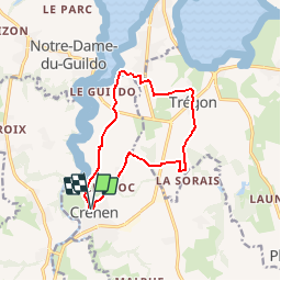
Randonnée Marche de 11,1 km à découvrir à Bretagne, Côtes-d'Armor, Créhen. Cette randonnée est proposée par tracegps.
Description
Circuit proposé par l’Office de Tourisme du Val d’Arguenon. Départ de l’église de Crehen. Retrouvez le circuit sur le site de l’office de Tourisme du Val d’Arguenon.
Localisation
Pays :
France
Région :
Bretagne
Département/Province :
Côtes-d'Armor
Commune :
Créhen
Localité :
Unknown
Départ:(Dec)
Départ:(UTM)
557973 ; 5377406 (30U) N.
Commentaires
Randonnées à proximité
![Randonnée Marche Saint-Jacut-de-la-Mer - St Jacut de la Mer 7.7.23 - Photo](https://media.geolcdn.com/t/375/260/7c37f328-93e1-4d4a-83bf-ec0b125bb7cd.jpg&format=jpg&maxdim=2)
![Marche Marche](https://static1.geolcdn.com/sitytour/trail-icons/101.png)
St Jacut de la Mer 7.7.23
Marche
Facile
Saint-Jacut-de-la-Mer,
Bretagne,
Côtes-d'Armor,
France
![](/images/other/stat-length.png)
10,2 km | 11,8 km-effort
3h 20min
![](https://static1.geolcdn.com/siteimages/upload/files/16400158638029165_repeat_loop_refresh_sync_direction_icon.png)
Oui
![Randonnée A pied Beaussais-sur-Mer - Circuit du Floubalay - Photo](https://media.geolcdn.com/t/375/260/552d4978-49a8-4dca-9300-802d468353f1.jpeg&format=jpg&maxdim=2)
![A pied A pied](https://static1.geolcdn.com/sitytour/trail-icons/100.png)
Circuit du Floubalay
A pied
Facile
Beaussais-sur-Mer,
Bretagne,
Côtes-d'Armor,
France
![](/images/other/stat-length.png)
4,4 km | 5 km-effort
1h 8min
![](https://static1.geolcdn.com/siteimages/upload/files/16400158638029165_repeat_loop_refresh_sync_direction_icon.png)
Non
![Randonnée A pied Beaussais-sur-Mer - Chemin des Dolmens - Photo](https://media.geolcdn.com/t/375/260/5f97a76e-17db-4c60-a005-1a71e6a46136.jpeg&format=jpg&maxdim=2)
![A pied A pied](https://static1.geolcdn.com/sitytour/trail-icons/100.png)
Chemin des Dolmens
A pied
Facile
Beaussais-sur-Mer,
Bretagne,
Côtes-d'Armor,
France
![](/images/other/stat-length.png)
8,3 km | 9,5 km-effort
2h 8min
![](https://static1.geolcdn.com/siteimages/upload/files/16400158638029165_repeat_loop_refresh_sync_direction_icon.png)
Oui
![Randonnée A pied Plancoët - Eau et Nature - Photo](https://media.geolcdn.com/t/375/260/606dd286-aa0a-48fe-9061-7d44267a5d9e.jpeg&format=jpg&maxdim=2)
![A pied A pied](https://static1.geolcdn.com/sitytour/trail-icons/100.png)
Eau et Nature
A pied
Facile
Plancoët,
Bretagne,
Côtes-d'Armor,
France
![](/images/other/stat-length.png)
11,2 km | 13,1 km-effort
2h 59min
![](https://static1.geolcdn.com/siteimages/upload/files/16400158638029165_repeat_loop_refresh_sync_direction_icon.png)
Non
![Randonnée Marche Créhen - St Jacut - île Ebihens - Photo](https://media.geolcdn.com/t/375/260/3210441b-681a-44fd-a32e-b60ec43af4b1.jpg&format=jpg&maxdim=2)
![Marche Marche](https://static1.geolcdn.com/sitytour/trail-icons/101.png)
St Jacut - île Ebihens
Marche
Facile
Créhen,
Bretagne,
Côtes-d'Armor,
France
![](/images/other/stat-length.png)
17,9 km | 21 km-effort
4h 15min
![](https://static1.geolcdn.com/siteimages/upload/files/16400158638029165_repeat_loop_refresh_sync_direction_icon.png)
Oui
![Randonnée Marche Saint-Lormel - ARGUENON MARITIME - Photo](https://media.geolcdn.com/t/375/260/ext.jpg?maxdim=2&url=https%3A%2F%2Fstatic1.geolcdn.com%2Fsiteimages%2Fupload%2Ffiles%2F1553511878bg_sport_marche.png)
![Marche Marche](https://static1.geolcdn.com/sitytour/trail-icons/101.png)
ARGUENON MARITIME
Marche
Moyen
(1)
Saint-Lormel,
Bretagne,
Côtes-d'Armor,
France
![](/images/other/stat-length.png)
13,8 km | 16,4 km-effort
4h 0min
![](https://static1.geolcdn.com/siteimages/upload/files/16400158638029165_repeat_loop_refresh_sync_direction_icon.png)
Non
![Randonnée A pied Beaussais-sur-Mer - Sentier de découverte du polder de Ploubalay - Photo](https://media.geolcdn.com/t/375/260/ext.jpg?maxdim=2&url=https%3A%2F%2Fstatic1.geolcdn.com%2Fsiteimages%2Fupload%2Ffiles%2F1545311037marcheuse_200dpi.jpg)
![A pied A pied](https://static1.geolcdn.com/sitytour/trail-icons/100.png)
Sentier de découverte du polder de Ploubalay
A pied
Facile
Beaussais-sur-Mer,
Bretagne,
Côtes-d'Armor,
France
![](/images/other/stat-length.png)
4,4 km | 4,8 km-effort
1h 5min
![](https://static1.geolcdn.com/siteimages/upload/files/16400158638029165_repeat_loop_refresh_sync_direction_icon.png)
Non
![Randonnée Course à pied Beaussais-sur-Mer - Les 4 vaux - Photo](https://media.geolcdn.com/t/375/260/ad215a4c-3d8e-4028-877a-a3fc32b08cac.jpg&format=jpg&maxdim=2)
![Course à pied Course à pied](https://static1.geolcdn.com/sitytour/trail-icons/103.png)
Les 4 vaux
Course à pied
Facile
Beaussais-sur-Mer,
Bretagne,
Côtes-d'Armor,
France
![](/images/other/stat-length.png)
10,1 km | 12,1 km-effort
1h 30min
![](https://static1.geolcdn.com/siteimages/upload/files/16400158638029165_repeat_loop_refresh_sync_direction_icon.png)
Non
![Randonnée Vélo de route Plancoët - de Plancoët fort la latte et cap Fréhel - Photo](https://media.geolcdn.com/t/375/260/ext.jpg?maxdim=2&url=https%3A%2F%2Fstatic1.geolcdn.com%2Fsiteimages%2Fupload%2Ffiles%2F1524743154velo.jpg)
![Vélo de route Vélo de route](https://static1.geolcdn.com/sitytour/trail-icons/201.png)
de Plancoët fort la latte et cap Fréhel
Vélo de route
Facile
Plancoët,
Bretagne,
Côtes-d'Armor,
France
![](/images/other/stat-length.png)
65 km | 75 km-effort
4h 11min
![](https://static1.geolcdn.com/siteimages/upload/files/16400158638029165_repeat_loop_refresh_sync_direction_icon.png)
Non