![](/images/other/stat-length.png)
![Randonnée Marche Bagnoles-de-l'Orne-Normandie - Bagnoles de l'Orne - Photo](https://media.geolcdn.com/t/1900/400/ext.pjpeg?maxdim=2&url=https%3A%2F%2Fservices.sitytrail.com%2FGeolivesWS%2FDownloadMedia.ashx%3FTrailID%3D111656%26Media%3D7894_2.jpg)
Bagnoles de l'Orne
tracegps
Utilisateur
![Longueur](/images/other/stat-length.png)
![Altitude max](https://static1.geolcdn.com/siteimages/upload/files/1508320355ic_sort_altitude_max_24dp.png)
![Dénivelé positif](https://static1.geolcdn.com/siteimages/upload/files/1508320355ic_sort_den_pos_24dp.png)
![Km-Effort](/images/other/stat-length.png)
![Altitude min](https://static1.geolcdn.com/siteimages/upload/files/1508320355ic_sort_altitude_min_24dp.png)
![Dénivelé négatif](https://static1.geolcdn.com/siteimages/upload/files/1508320355ic_sort_den_neg_24dp.png)
![Boucle](https://static1.geolcdn.com/siteimages/upload/files/16400158638029165_repeat_loop_refresh_sync_direction_icon.png)
![Marche](https://static1.geolcdn.com/sitytour/trail-icons/101.png)
4h00
Difficulté : Moyen
![Scannez ce code QR pour ouvrir la randonnée dans l'application SityTrail](https://capi.geolives.com/qq0zvz2zws4bq2lad0pu/sitytour/trails/111656/qr.png?size=200)
Application GPS de randonnée GRATUITE
À propos
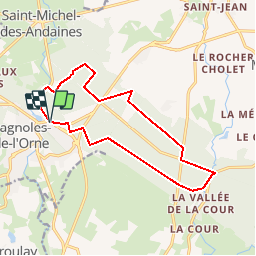
Randonnée Marche de 13,2 km à découvrir à Normandie, Orne, Bagnoles-de-l'Orne-Normandie. Cette randonnée est proposée par tracegps.
Description
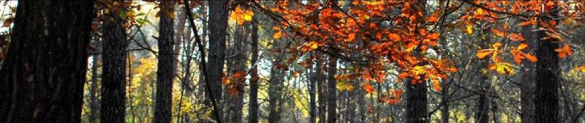
Bagnoles de l’Orne. Aux portes de la station thermale, le chêne Hippolyte règne, tel un seigneur, sur cette partie de la forêt qui offre ses futaies, hautes en couleurs à chaque saison et quelques surprises. Retrouvez les Coup de Cœur Randonnée dans l’Orne en Normandie.
Localisation
Commentaires
Randonnées à proximité
![Randonnée A pied Rives-d'Andaine - Sentier des Templiers - Photo](https://media.geolcdn.com/t/375/260/7f8f2913-590f-4c31-b4e9-64954dd46906.jpeg&format=jpg&maxdim=2)
![A pied A pied](https://static1.geolcdn.com/sitytour/trail-icons/100.png)
A pied
![](/images/other/stat-length.png)
![](https://static1.geolcdn.com/siteimages/upload/files/16400158638029165_repeat_loop_refresh_sync_direction_icon.png)
![Randonnée Marche Bagnoles-de-l'Orne-Normandie - Saint Ortaire - Photo](https://media.geolcdn.com/t/375/260/ext.jpg?maxdim=2&url=https%3A%2F%2Fstatic1.geolcdn.com%2Fsiteimages%2Fupload%2Ffiles%2F1553511878bg_sport_marche.png)
![Marche Marche](https://static1.geolcdn.com/sitytour/trail-icons/101.png)
Marche
![](/images/other/stat-length.png)
![](https://static1.geolcdn.com/siteimages/upload/files/16400158638029165_repeat_loop_refresh_sync_direction_icon.png)
![Randonnée Marche Bagnoles-de-l'Orne-Normandie - Forêt d'Andaine - Photo](https://media.geolcdn.com/t/375/260/4445009f-5e34-4cf0-9270-1184d385e215.jpg&format=jpg&maxdim=2)
![Marche Marche](https://static1.geolcdn.com/sitytour/trail-icons/101.png)
Marche
![](/images/other/stat-length.png)
![](https://static1.geolcdn.com/siteimages/upload/files/16400158638029165_repeat_loop_refresh_sync_direction_icon.png)
![Randonnée A pied Bagnoles-de-l'Orne-Normandie - Les Arbres remarquables de Bagnoles-de-l'Orne - Photo](https://media.geolcdn.com/t/375/260/3f5af4f6-b5c2-468d-a381-1ea1dcd7f8d4.jpeg&format=jpg&maxdim=2)
![A pied A pied](https://static1.geolcdn.com/sitytour/trail-icons/100.png)
A pied
![](/images/other/stat-length.png)
![](https://static1.geolcdn.com/siteimages/upload/files/16400158638029165_repeat_loop_refresh_sync_direction_icon.png)
![Randonnée A pied Bagnoles-de-l'Orne-Normandie - Bagnoles-de-l'Orne - Photo](https://media.geolcdn.com/t/375/260/352c0479-80dd-4a7d-ade5-52d7e1895bb3.jpeg&format=jpg&maxdim=2)
![A pied A pied](https://static1.geolcdn.com/sitytour/trail-icons/100.png)
A pied
![](/images/other/stat-length.png)
![](https://static1.geolcdn.com/siteimages/upload/files/16400158638029165_repeat_loop_refresh_sync_direction_icon.png)
![Randonnée A pied La Ferté-Macé - Circuit des Bornes Cavalières - Photo](https://media.geolcdn.com/t/375/260/ae4572a0-be41-42e4-9cb7-abcf5f5905ac.jpeg&format=jpg&maxdim=2)
![A pied A pied](https://static1.geolcdn.com/sitytour/trail-icons/100.png)
A pied
![](/images/other/stat-length.png)
![](https://static1.geolcdn.com/siteimages/upload/files/16400158638029165_repeat_loop_refresh_sync_direction_icon.png)
![Randonnée V.T.C. Bagnoles-de-l'Orne-Normandie - bagnoles de l'ore - Photo](https://media.geolcdn.com/t/375/260/4eea9336-edc2-458e-9d5f-3a5eced18dc8.jpg&format=jpg&maxdim=2)
![V.T.C. V.T.C.](https://static1.geolcdn.com/sitytour/trail-icons/203.png)
V.T.C.
![](/images/other/stat-length.png)
![](https://static1.geolcdn.com/siteimages/upload/files/16400158638029165_repeat_loop_refresh_sync_direction_icon.png)
![Randonnée Marche Magny-le-Désert - Andaines - Villiers - Photo](https://media.geolcdn.com/t/375/260/ext.jpg?maxdim=2&url=https%3A%2F%2Fstatic1.geolcdn.com%2Fsiteimages%2Fupload%2Ffiles%2F1553511878bg_sport_marche.png)
![Marche Marche](https://static1.geolcdn.com/sitytour/trail-icons/101.png)
Marche
![](/images/other/stat-length.png)
![](https://static1.geolcdn.com/siteimages/upload/files/16400158638029165_repeat_loop_refresh_sync_direction_icon.png)
![Randonnée Marche Bagnoles-de-l'Orne-Normandie - Bagnoles de l' orne - Photo](https://media.geolcdn.com/t/375/260/fa0660f3-37d7-48ea-8a93-ad724fc5fdf8.jpg&format=jpg&maxdim=2)
![Marche Marche](https://static1.geolcdn.com/sitytour/trail-icons/101.png)
Marche
![](/images/other/stat-length.png)
![](https://static1.geolcdn.com/siteimages/upload/files/16400158638029165_repeat_loop_refresh_sync_direction_icon.png)