![](/images/other/stat-length.png)
![Randonnée Marche Feings - Attelage - Forêt et Panoramas - forêt de Réno-Valdieu - Photo](https://media.geolcdn.com/t/1900/400/ext.pjpeg?maxdim=2&url=https%3A%2F%2Fservices.sitytrail.com%2FGeolivesWS%2FDownloadMedia.ashx%3FTrailID%3D111646%26Media%3D7888_2.jpg)
Attelage - Forêt et Panoramas - forêt de Réno-Valdieu
tracegps
Utilisateur
![Longueur](/images/other/stat-length.png)
Longueur
20 km
![Altitude max](https://static1.geolcdn.com/siteimages/upload/files/1508320355ic_sort_altitude_max_24dp.png)
Altitude max
259 m
![Dénivelé positif](https://static1.geolcdn.com/siteimages/upload/files/1508320355ic_sort_den_pos_24dp.png)
Dénivelé positif
429 m
![Km-Effort](/images/other/stat-length.png)
Km-Effort
26 km
![Altitude min](https://static1.geolcdn.com/siteimages/upload/files/1508320355ic_sort_altitude_min_24dp.png)
Altitude min
155 m
![Dénivelé négatif](https://static1.geolcdn.com/siteimages/upload/files/1508320355ic_sort_den_neg_24dp.png)
Dénivelé négatif
429 m
![Boucle](https://static1.geolcdn.com/siteimages/upload/files/16400158638029165_repeat_loop_refresh_sync_direction_icon.png)
Boucle
Oui
Date de création :
2014-12-10 00:00:00.0
Dernière modification :
2014-12-10 00:00:00.0
![Marche](https://static1.geolcdn.com/sitytour/trail-icons/101.png)
4h00
Difficulté : Difficile
![Scannez ce code QR pour ouvrir la randonnée dans l'application SityTrail](https://capi.geolives.com/qq0zvz2zws4bq2lad0pu/sitytour/trails/111646/qr.png?size=200)
Application GPS de randonnée GRATUITE
À propos
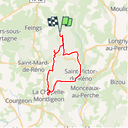
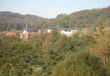
Randonnée Marche de 20 km à découvrir à Normandie, Orne, Feings. Cette randonnée est proposée par tracegps.
Description
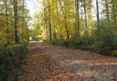
Attelage - Forêt et Panoramas (journée) - forêt de Réno-Valdieu Circuit d'attelage, praticable à pied et à VTT. Retrouvez les Coup de Cœur Randonnée dans l’Orne en Normandie.
Localisation
Pays :
France
Région :
Normandie
Département/Province :
Orne
Commune :
Feings
Localité :
Unknown
Départ:(Dec)
Départ:(UTM)
328110 ; 5378997 (31U) N.
Commentaires
Randonnées à proximité
![Randonnée A pied Longny les Villages - Attelage - Forêt et Panoramas - forêt de Réno-Valdieu - Photo](https://media.geolcdn.com/t/375/260/db99a0ed-9413-4500-8368-446623bccd86.jpeg&format=jpg&maxdim=2)
![A pied A pied](https://static1.geolcdn.com/sitytour/trail-icons/100.png)
Attelage - Forêt et Panoramas - forêt de Réno-Valdieu
A pied
Facile
Longny les Villages,
Normandie,
Orne,
France
![](/images/other/stat-length.png)
7,6 km | 9,3 km-effort
2h 7min
![](https://static1.geolcdn.com/siteimages/upload/files/16400158638029165_repeat_loop_refresh_sync_direction_icon.png)
Non
![Randonnée Marche Longny les Villages - La Fonte - Malétable 7,8 km - Photo](https://media.geolcdn.com/t/375/260/58715638-860a-4ade-9990-a9918a4f42a8.jpeg&format=jpg&maxdim=2)
![Marche Marche](https://static1.geolcdn.com/sitytour/trail-icons/101.png)
La Fonte - Malétable 7,8 km
Marche
Facile
Longny les Villages,
Normandie,
Orne,
France
![](/images/other/stat-length.png)
7,8 km | 9,2 km-effort
21min
![](https://static1.geolcdn.com/siteimages/upload/files/16400158638029165_repeat_loop_refresh_sync_direction_icon.png)
Oui
![Randonnée Marche Feings - Perche-Le Valdieu - Forêt de Réno-Valdieu - - Photo](https://media.geolcdn.com/t/375/260/3680a9e7-0933-4c18-9cee-f8b32abef75f.jpg&format=jpg&maxdim=2)
![Marche Marche](https://static1.geolcdn.com/sitytour/trail-icons/101.png)
Perche-Le Valdieu - Forêt de Réno-Valdieu -
Marche
Très facile
Feings,
Normandie,
Orne,
France
![](/images/other/stat-length.png)
7,6 km | 9,3 km-effort
3h 5min
![](https://static1.geolcdn.com/siteimages/upload/files/16400158638029165_repeat_loop_refresh_sync_direction_icon.png)
Oui
![Randonnée Cheval Feings - Attelage en forêt domaniale de Reno-Valdieu - Feings - Photo](https://media.geolcdn.com/t/375/260/ext.jpg?maxdim=2&url=https%3A%2F%2Fservices.sitytrail.com%2FGeolivesWS%2FDownloadMedia.ashx%3FTrailID%3D112045%26Media%3D9573_2.jpg)
![Cheval Cheval](https://static1.geolcdn.com/sitytour/trail-icons/300.png)
Attelage en forêt domaniale de Reno-Valdieu - Feings
Cheval
Moyen
Feings,
Normandie,
Orne,
France
![](/images/other/stat-length.png)
11,4 km | 14,1 km-effort
3h 0min
![](https://static1.geolcdn.com/siteimages/upload/files/16400158638029165_repeat_loop_refresh_sync_direction_icon.png)
Oui
![Randonnée Marche Tourouvre au Perche - Bellegarde - Autheuil - Photo](https://media.geolcdn.com/t/375/260/ext.jpg?maxdim=2&url=https%3A%2F%2Fservices.sitytrail.com%2FGeolivesWS%2FDownloadMedia.ashx%3FTrailID%3D111657%26Media%3D7895_1.jpg)
![Marche Marche](https://static1.geolcdn.com/sitytour/trail-icons/101.png)
Bellegarde - Autheuil
Marche
Facile
(1)
Tourouvre au Perche,
Normandie,
Orne,
France
![](/images/other/stat-length.png)
3,8 km | 4,8 km-effort
1h 19min
![](https://static1.geolcdn.com/siteimages/upload/files/16400158638029165_repeat_loop_refresh_sync_direction_icon.png)
Oui
![Randonnée Cheval Feings - Attelage - Forêt et Panoramas - forêt de Réno-Valdieu - Photo](https://media.geolcdn.com/t/375/260/ext.jpg?maxdim=2&url=https%3A%2F%2Fservices.sitytrail.com%2FGeolivesWS%2FDownloadMedia.ashx%3FTrailID%3D111648%26Media%3D7888_2.jpg)
![Cheval Cheval](https://static1.geolcdn.com/sitytour/trail-icons/300.png)
Attelage - Forêt et Panoramas - forêt de Réno-Valdieu
Cheval
Moyen
Feings,
Normandie,
Orne,
France
![](/images/other/stat-length.png)
20 km | 26 km-effort
5h 0min
![](https://static1.geolcdn.com/siteimages/upload/files/16400158638029165_repeat_loop_refresh_sync_direction_icon.png)
Oui
![Randonnée V.T.T. Feings - Attelage - Forêt et Panoramas - forêt de Réno-Valdieu - Photo](https://media.geolcdn.com/t/375/260/ext.jpg?maxdim=2&url=https%3A%2F%2Fservices.sitytrail.com%2FGeolivesWS%2FDownloadMedia.ashx%3FTrailID%3D111647%26Media%3D7888_2.jpg)
![V.T.T. V.T.T.](https://static1.geolcdn.com/sitytour/trail-icons/202.png)
Attelage - Forêt et Panoramas - forêt de Réno-Valdieu
V.T.T.
Moyen
Feings,
Normandie,
Orne,
France
![](/images/other/stat-length.png)
20 km | 26 km-effort
1h 30min
![](https://static1.geolcdn.com/siteimages/upload/files/16400158638029165_repeat_loop_refresh_sync_direction_icon.png)
Oui
![Randonnée Marche Saint-Mard-de-Réno - Saint-Mard de Réno - La chute de Beillard - Départ de Saint-Mard 8,1 km - Photo](https://media.geolcdn.com/t/375/260/ext.jpg?maxdim=2&url=https%3A%2F%2Fstatic1.geolcdn.com%2Fsiteimages%2Fupload%2Ffiles%2F1553511878bg_sport_marche.png)
![Marche Marche](https://static1.geolcdn.com/sitytour/trail-icons/101.png)
Saint-Mard de Réno - La chute de Beillard - Départ de Saint-Mard 8,1 km
Marche
Moyen
Saint-Mard-de-Réno,
Normandie,
Orne,
France
![](/images/other/stat-length.png)
8,1 km | 9,2 km-effort
2h 5min
![](https://static1.geolcdn.com/siteimages/upload/files/16400158638029165_repeat_loop_refresh_sync_direction_icon.png)
Oui
![Randonnée Marche Feings - Feing - Les vieux arbres 10 km - Photo](https://media.geolcdn.com/t/375/260/ext.jpg?maxdim=2&url=https%3A%2F%2Fstatic1.geolcdn.com%2Fsiteimages%2Fupload%2Ffiles%2F1553511878bg_sport_marche.png)
![Marche Marche](https://static1.geolcdn.com/sitytour/trail-icons/101.png)
Feing - Les vieux arbres 10 km
Marche
Difficile
Feings,
Normandie,
Orne,
France
![](/images/other/stat-length.png)
10,1 km | 12,9 km-effort
2h 55min
![](https://static1.geolcdn.com/siteimages/upload/files/16400158638029165_repeat_loop_refresh_sync_direction_icon.png)
Oui