![](/images/other/stat-length.png)
![Randonnée Vélo Chalabre - CCS FFC Aude en Pyrénées - Circuit n°03 - Chalabre - Photo](https://media.geolcdn.com/t/1900/400/ext.pjpeg?maxdim=2&url=https%3A%2F%2Fservices.sitytrail.com%2FGeolivesWS%2FDownloadMedia.ashx%3FTrailID%3D111462%26Media%3D7345_1.jpg)
CCS FFC Aude en Pyrénées - Circuit n°03 - Chalabre
tracegps
Utilisateur
![Longueur](/images/other/stat-length.png)
Longueur
19,5 km
![Altitude max](https://static1.geolcdn.com/siteimages/upload/files/1508320355ic_sort_altitude_max_24dp.png)
Altitude max
548 m
![Dénivelé positif](https://static1.geolcdn.com/siteimages/upload/files/1508320355ic_sort_den_pos_24dp.png)
Dénivelé positif
247 m
![Km-Effort](/images/other/stat-length.png)
Km-Effort
23 km
![Altitude min](https://static1.geolcdn.com/siteimages/upload/files/1508320355ic_sort_altitude_min_24dp.png)
Altitude min
371 m
![Dénivelé négatif](https://static1.geolcdn.com/siteimages/upload/files/1508320355ic_sort_den_neg_24dp.png)
Dénivelé négatif
247 m
![Boucle](https://static1.geolcdn.com/siteimages/upload/files/16400158638029165_repeat_loop_refresh_sync_direction_icon.png)
Boucle
Oui
Date de création :
2014-12-10 00:00:00.0
Dernière modification :
2014-12-10 00:00:00.0
![Vélo](https://static1.geolcdn.com/sitytour/trail-icons/200.png)
1h00
Difficulté : Facile
![Scannez ce code QR pour ouvrir la randonnée dans l'application SityTrail](https://capi.geolives.com/qq0zvz2zws4bq2lad0pu/sitytour/trails/111462/qr.png?size=200)
Application GPS de randonnée GRATUITE
À propos
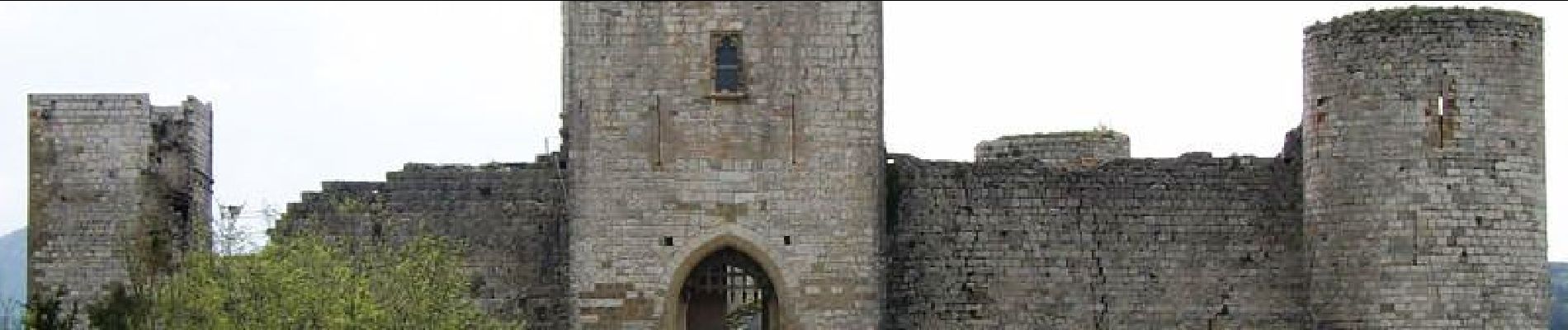
Randonnée Vélo de 19,5 km à découvrir à Occitanie, Aude, Chalabre. Cette randonnée est proposée par tracegps.
Description
Une petite boucle facilement accessible et qui permet en passant par le col du Boyer d’apprécier le site de Puivert et le village de Rivel. Textes de Patrick Rault et Louis Mounié.
Localisation
Pays :
France
Région :
Occitanie
Département/Province :
Aude
Commune :
Chalabre
Localité :
Unknown
Départ:(Dec)
Départ:(UTM)
419060 ; 4759498 (31T) N.
Commentaires
Randonnées à proximité
![Randonnée Marche Rivel - Au fil de l'eau - Rivel - Photo](https://media.geolcdn.com/t/375/260/ext.jpg?maxdim=2&url=https%3A%2F%2Fservices.sitytrail.com%2FGeolivesWS%2FDownloadMedia.ashx%3FTrailID%3D111543%26Media%3D7620_6.jpg)
![Marche Marche](https://static1.geolcdn.com/sitytour/trail-icons/101.png)
Au fil de l'eau - Rivel
Marche
Moyen
(1)
Rivel,
Occitanie,
Aude,
France
![](/images/other/stat-length.png)
5,2 km | 7 km-effort
1h 45min
![](https://static1.geolcdn.com/siteimages/upload/files/16400158638029165_repeat_loop_refresh_sync_direction_icon.png)
Oui
![Randonnée Marche Rivel - Le chemin du château - Rivel - Photo](https://media.geolcdn.com/t/375/260/ext.jpg?maxdim=2&url=https%3A%2F%2Fservices.sitytrail.com%2FGeolivesWS%2FDownloadMedia.ashx%3FTrailID%3D111547%26Media%3D7636_6.jpg)
![Marche Marche](https://static1.geolcdn.com/sitytour/trail-icons/101.png)
Le chemin du château - Rivel
Marche
Facile
(1)
Rivel,
Occitanie,
Aude,
France
![](/images/other/stat-length.png)
2,4 km | 4 km-effort
45min
![](https://static1.geolcdn.com/siteimages/upload/files/16400158638029165_repeat_loop_refresh_sync_direction_icon.png)
Oui
![Randonnée Marche Montbel - Lac de Montbel - Photo](https://media.geolcdn.com/t/375/260/ext.jpg?maxdim=2&url=https%3A%2F%2Fservices.sitytrail.com%2FGeolivesWS%2FDownloadMedia.ashx%3FTrailID%3D108634%26Media%3D1546_1.jpg)
![Marche Marche](https://static1.geolcdn.com/sitytour/trail-icons/101.png)
Lac de Montbel
Marche
Moyen
(2)
Montbel,
Occitanie,
Ariège,
France
![](/images/other/stat-length.png)
15,8 km | 18,4 km-effort
3h 19min
![](https://static1.geolcdn.com/siteimages/upload/files/16400158638029165_repeat_loop_refresh_sync_direction_icon.png)
Oui
![Randonnée Marche Montbel - 1/2 tour a Montbel - Photo](https://media.geolcdn.com/t/375/260/04f81fef-1f32-4c7b-bbc0-0fcf03103e41.jpg&format=jpg&maxdim=2)
![Marche Marche](https://static1.geolcdn.com/sitytour/trail-icons/101.png)
1/2 tour a Montbel
Marche
Facile
Montbel,
Occitanie,
Ariège,
France
![](/images/other/stat-length.png)
48 km | 55 km-effort
2h 10min
![](https://static1.geolcdn.com/siteimages/upload/files/16400158638029165_repeat_loop_refresh_sync_direction_icon.png)
Non
![Randonnée A pied Montbel - Tour du Lac de Montbel - Photo](https://media.geolcdn.com/t/375/260/25dcfb65-b7fe-4eef-9118-1046e41dc897.jpeg&format=jpg&maxdim=2)
![A pied A pied](https://static1.geolcdn.com/sitytour/trail-icons/100.png)
Tour du Lac de Montbel
A pied
Facile
Montbel,
Occitanie,
Ariège,
France
![](/images/other/stat-length.png)
15,3 km | 17,9 km-effort
4h 4min
![](https://static1.geolcdn.com/siteimages/upload/files/16400158638029165_repeat_loop_refresh_sync_direction_icon.png)
Oui
![Randonnée Vélo Chalabre - Chalabre - Limoux - Espéraza - Photo](https://media.geolcdn.com/t/375/260/ext.jpg?maxdim=2&url=https%3A%2F%2Fservices.sitytrail.com%2FGeolivesWS%2FDownloadMedia.ashx%3FTrailID%3D316835%26Media%3D15898_3.jpg)
![Vélo Vélo](https://static1.geolcdn.com/sitytour/trail-icons/200.png)
Chalabre - Limoux - Espéraza
Vélo
Difficile
Chalabre,
Occitanie,
Aude,
France
![](/images/other/stat-length.png)
72 km | 88 km-effort
4h 30min
![](https://static1.geolcdn.com/siteimages/upload/files/16400158638029165_repeat_loop_refresh_sync_direction_icon.png)
Oui
![Randonnée Cheval Chalabre - La colline du calvaire - Chalabre - Photo](https://media.geolcdn.com/t/375/260/ext.jpg?maxdim=2&url=https%3A%2F%2Fservices.sitytrail.com%2FGeolivesWS%2FDownloadMedia.ashx%3FTrailID%3D111541%26Media%3D7599_4.jpg)
![Cheval Cheval](https://static1.geolcdn.com/sitytour/trail-icons/300.png)
La colline du calvaire - Chalabre
Cheval
Facile
Chalabre,
Occitanie,
Aude,
France
![](/images/other/stat-length.png)
4,4 km | 6,4 km-effort
1h 0min
![](https://static1.geolcdn.com/siteimages/upload/files/16400158638029165_repeat_loop_refresh_sync_direction_icon.png)
Oui
![Randonnée Marche Chalabre - La colline du calvaire - Chalabre - Photo](https://media.geolcdn.com/t/375/260/ext.jpg?maxdim=2&url=https%3A%2F%2Fservices.sitytrail.com%2FGeolivesWS%2FDownloadMedia.ashx%3FTrailID%3D111540%26Media%3D7599_4.jpg)
![Marche Marche](https://static1.geolcdn.com/sitytour/trail-icons/101.png)
La colline du calvaire - Chalabre
Marche
Facile
Chalabre,
Occitanie,
Aude,
France
![](/images/other/stat-length.png)
4,4 km | 6,4 km-effort
1h 30min
![](https://static1.geolcdn.com/siteimages/upload/files/16400158638029165_repeat_loop_refresh_sync_direction_icon.png)
Oui
![Randonnée Marche Chalabre - Circuit de découverte de Chalabre - Photo](https://media.geolcdn.com/t/375/260/ext.jpg?maxdim=2&url=https%3A%2F%2Fservices.sitytrail.com%2FGeolivesWS%2FDownloadMedia.ashx%3FTrailID%3D111539%26Media%3D7598_6.jpg)
![Marche Marche](https://static1.geolcdn.com/sitytour/trail-icons/101.png)
Circuit de découverte de Chalabre
Marche
Facile
Chalabre,
Occitanie,
Aude,
France
![](/images/other/stat-length.png)
3,5 km | 3,9 km-effort
1h 0min
![](https://static1.geolcdn.com/siteimages/upload/files/16400158638029165_repeat_loop_refresh_sync_direction_icon.png)
Oui