![](/images/other/stat-length.png)
![Randonnée Autre activité Fort-de-France - Absalon - Cascades Didier-Duclos 190222 - Photo](https://media.geolcdn.com/t/1900/400/ext.pjpeg?maxdim=2&url=https%3A%2F%2Fstatic1.geolcdn.com%2Fsiteimages%2Fupload%2Ffiles%2F1545311037marcheuse_200dpi.jpg)
Absalon - Cascades Didier-Duclos 190222
JohnTompa
Utilisateur
![Longueur](/images/other/stat-length.png)
Longueur
3,8 km
![Altitude max](https://static1.geolcdn.com/siteimages/upload/files/1508320355ic_sort_altitude_max_24dp.png)
Altitude max
409 m
![Dénivelé positif](https://static1.geolcdn.com/siteimages/upload/files/1508320355ic_sort_den_pos_24dp.png)
Dénivelé positif
250 m
![Km-Effort](/images/other/stat-length.png)
Km-Effort
7 km
![Altitude min](https://static1.geolcdn.com/siteimages/upload/files/1508320355ic_sort_altitude_min_24dp.png)
Altitude min
217 m
![Dénivelé négatif](https://static1.geolcdn.com/siteimages/upload/files/1508320355ic_sort_den_neg_24dp.png)
Dénivelé négatif
219 m
![Boucle](https://static1.geolcdn.com/siteimages/upload/files/16400158638029165_repeat_loop_refresh_sync_direction_icon.png)
Boucle
Non
Date de création :
2019-05-02 17:48:22.757
Dernière modification :
2019-05-02 17:48:22.757
![Autre activité](https://static1.geolcdn.com/sitytour/trail-icons/900.png)
3h00
Difficulté : Inconnu
![Scannez ce code QR pour ouvrir la randonnée dans l'application SityTrail](https://capi.geolives.com/qq0zvz2zws4bq2lad0pu/sitytour/trails/1114086/qr.png?size=200)
Application GPS de randonnée GRATUITE
À propos
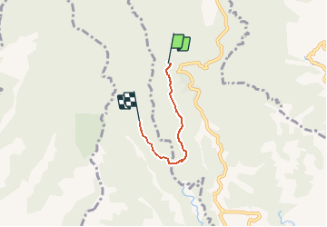
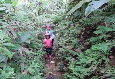
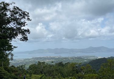
Randonnée Autre activité de 3,8 km à découvrir à Martinique, Inconnu, Fort-de-France. Cette randonnée est proposée par JohnTompa.
Description
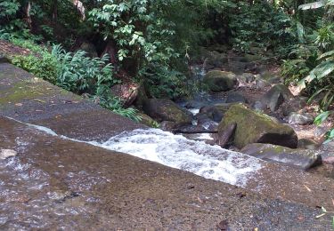
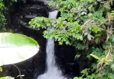
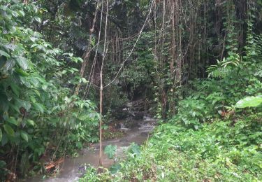
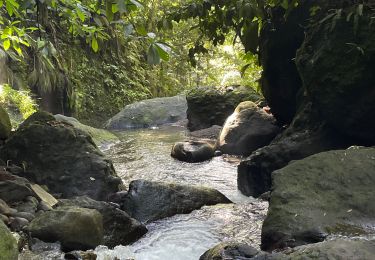
Rando du Jeudi. Ansalon - Didier - Tunnel - Rivière Duclos - 1er Cascade - 2ième Cascade.
Aller Simple.
Retour par le même chemon
Localisation
Pays :
France
Région :
Martinique
Département/Province :
Inconnu
Commune :
Fort-de-France
Localité :
Unknown
Départ:(Dec)
Départ:(UTM)
705111 ; 1623476 (20P) N.
Commentaires
Randonnées à proximité
![Randonnée sport Fort-de-France - Absalon vers Didier - Photo](https://media.geolcdn.com/t/375/260/adf8a0b9-d2e0-4a1f-aaf4-a96938158482.jpg&format=jpg&maxdim=2)
Absalon vers Didier
sport
Très facile
(1)
Fort-de-France,
Martinique,
Inconnu,
France
![](/images/other/stat-length.png)
6,3 km | 8,9 km-effort
Inconnu
![](https://static1.geolcdn.com/siteimages/upload/files/16400158638029165_repeat_loop_refresh_sync_direction_icon.png)
Non
![Randonnée Marche Fort-de-France - fond barron - Photo](https://media.geolcdn.com/t/375/260/e47fa9db-42eb-4eae-be0a-ef7b2c9eca79.jpg&format=jpg&maxdim=2)
![Marche Marche](https://static1.geolcdn.com/sitytour/trail-icons/101.png)
fond barron
Marche
Difficile
(1)
Fort-de-France,
Martinique,
Inconnu,
France
![](/images/other/stat-length.png)
6,4 km | 10 km-effort
2h 50min
![](https://static1.geolcdn.com/siteimages/upload/files/16400158638029165_repeat_loop_refresh_sync_direction_icon.png)
Oui
![Randonnée Marche Saint-Joseph - Forêt de Rabuchon - Photo](https://media.geolcdn.com/t/375/260/ext.jpg?maxdim=2&url=https%3A%2F%2Fservices.sitytrail.com%2FGeolivesWS%2FDownloadMedia.ashx%3FTrailID%3D316815%26Media%3D10634_4.jpg)
![Marche Marche](https://static1.geolcdn.com/sitytour/trail-icons/101.png)
Forêt de Rabuchon
Marche
Moyen
(1)
Saint-Joseph,
Martinique,
Inconnu,
France
![](/images/other/stat-length.png)
12 km | 21 km-effort
4h 0min
![](https://static1.geolcdn.com/siteimages/upload/files/16400158638029165_repeat_loop_refresh_sync_direction_icon.png)
Oui
![Randonnée Marche Fort-de-France - Absalon - Photo](https://media.geolcdn.com/t/375/260/878d5ce9-c2d9-41df-828d-f3fa710d1ba4.jpg&format=jpg&maxdim=2)
![Marche Marche](https://static1.geolcdn.com/sitytour/trail-icons/101.png)
Absalon
Marche
Difficile
Fort-de-France,
Martinique,
Inconnu,
France
![](/images/other/stat-length.png)
4,1 km | 7,9 km-effort
2h 25min
![](https://static1.geolcdn.com/siteimages/upload/files/16400158638029165_repeat_loop_refresh_sync_direction_icon.png)
Oui
![Randonnée Marche Saint-Joseph - Marche de bouliķi vers le bourg de st Joseph. - Photo](https://media.geolcdn.com/t/375/260/77d9f075-e645-4623-82b2-1841b98ea18b.jpg&format=jpg&maxdim=2)
![Marche Marche](https://static1.geolcdn.com/sitytour/trail-icons/101.png)
Marche de bouliķi vers le bourg de st Joseph.
Marche
Très facile
Saint-Joseph,
Martinique,
Inconnu,
France
![](/images/other/stat-length.png)
5,5 km | 7,8 km-effort
1h 49min
![](https://static1.geolcdn.com/siteimages/upload/files/16400158638029165_repeat_loop_refresh_sync_direction_icon.png)
Non
![Randonnée Marche Le Morne-Vert - Trace Ti Jadin - Photo](https://media.geolcdn.com/t/375/260/3605b413-cbf4-425a-83cb-a870f6ded4a5.jpg&format=jpg&maxdim=2)
![Marche Marche](https://static1.geolcdn.com/sitytour/trail-icons/101.png)
Trace Ti Jadin
Marche
Très facile
Le Morne-Vert,
Martinique,
Inconnu,
France
![](/images/other/stat-length.png)
3,3 km | 5,2 km-effort
2h 11min
![](https://static1.geolcdn.com/siteimages/upload/files/16400158638029165_repeat_loop_refresh_sync_direction_icon.png)
Oui
![Randonnée sport Fort-de-France - Didier absalon - Photo](https://media.geolcdn.com/t/375/260/554aad06-3441-4127-b415-2ba108c5a5e9.jpg&format=jpg&maxdim=2)
Didier absalon
sport
Très facile
Fort-de-France,
Martinique,
Inconnu,
France
![](/images/other/stat-length.png)
6,8 km | 9,6 km-effort
Inconnu
![](https://static1.geolcdn.com/siteimages/upload/files/16400158638029165_repeat_loop_refresh_sync_direction_icon.png)
Oui
![Randonnée sport Saint-Joseph - Boucle de rabuchon - Photo](https://media.geolcdn.com/t/375/260/73952a33-b4e2-4260-8c09-d51c749c2152.jpg&format=jpg&maxdim=2)
Boucle de rabuchon
sport
Très facile
Saint-Joseph,
Martinique,
Inconnu,
France
![](/images/other/stat-length.png)
21 km | 32 km-effort
Inconnu
![](https://static1.geolcdn.com/siteimages/upload/files/16400158638029165_repeat_loop_refresh_sync_direction_icon.png)
Non
![Randonnée sport Le Morne-Vert - Morne vert - Photo](https://media.geolcdn.com/t/375/260/08cf45e5-b64f-4338-9c76-38fd8ab1ca34.jpg&format=jpg&maxdim=2)
Morne vert
sport
Très facile
Le Morne-Vert,
Martinique,
Inconnu,
France
![](/images/other/stat-length.png)
3,2 km | 4,5 km-effort
Inconnu
![](https://static1.geolcdn.com/siteimages/upload/files/16400158638029165_repeat_loop_refresh_sync_direction_icon.png)
Non