Randonnée Marche Jungholtz - 68 Thierenbach - Auberge du Vallon Guebwiller - Photo

68 Thierenbach - Auberge du Vallon Guebwiller

 E.BURCK
E.BURCK

Utilisateur

© OpenStreetMap contributors
Longueur
Longueur
11,1 km
Altitude max
Altitude max
486 m
Dénivelé positif
Dénivelé positif
421 m
Km-Effort
Km-Effort  
16,8 km
Altitude min
Altitude min
316 m
Dénivelé négatif
Dénivelé négatif
419 m
Boucle
Boucle
Oui
Date de création :
2019-05-22 16:11:35.966
Dernière modification :
2019-12-18 14:36:33.747

(0 Avis)

Marche
Marche
3h28
Difficulté : Moyen

Scannez ce code QR pour ouvrir la randonnée dans l'application SityTrail

Application GPS de randonnée GRATUITE

Logo SityTrail SityTrail

IGN / Instituts géographiques

Télécharger SityTrail sur l'App Store Télécharger SityTrail sur Google Play

Logo SityTrail SityTrail World

Le monde est à vous

Télécharger SityTrail sur l'App Store Télécharger SityTrail sur Google Play Télécharger SityTrail sur Huawei AppGallery

À propos

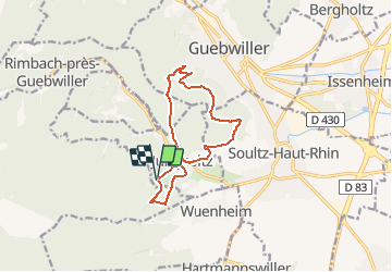
Randonnée Marche de 11,1 km à découvrir à Grand Est, Haut-Rhin, Jungholtz. Cette randonnée est proposée par E.BURCK.

Description

ACCÈS : - Soultz, Jungholtz puis Thierenbach       PARKING de la Basilique de Thierenbach.              
   47.88102,           7.18976
N 47°52'51.7"      E 07°11'23.1"  
RESTAURATION :  
Auberge du Vallon à GuebwillerTél.: 03 89 74 89 86

Profil altimétrique

Localisation

Pays :
France
Région :
Grand Est
Département/Province :
Haut-Rhin
Commune :
Jungholtz
Localité :
Unknown
Départ:(Dec)
Départ:(UTM)
364600 ; 5304703 (32T) N.

Randonnées à proximité

Randonnée Marche Soultz-Haut-Rhin - Hartmannswillerkopf - Circuit découverte - Photo
Marche
VacheKiri67

Marche

Facile
(1)
Soultz-Haut-Rhin, Grand Est, Haut-Rhin, France
3,6 km | 5,2 km-effort
1h 46min
Oui
Randonnée Marche Soultz-Haut-Rhin - Hartmannswillerkopf - Circuit anneau bleu - Photo
Marche
VacheKiri67

Marche

Moyen
(1)
Soultz-Haut-Rhin, Grand Est, Haut-Rhin, France
3,7 km | 5,9 km-effort
1h 37min
Oui
Randonnée A pied Goldbach-Altenbach - Firstacker - Willer sur Thur - Photo
A pied
GUIDE+

A pied

Facile
Goldbach-Altenbach, Grand Est, Haut-Rhin, France
7,4 km | 9,6 km-effort
2h 11min
Non
Randonnée V.T.T. Guebwiller - P4  Circuits du Florival 2021   - Photo
V.T.T.
duchaine.nicolas

V.T.T.

Moyen
(1)
Guebwiller, Grand Est, Haut-Rhin, France
40 km | 53 km-effort
4h 31min
Non
Randonnée Trail Wattwiller - The History Ultra - Stage 1 - Photo
Trail
Olivier Houette

Trail

Très facile
(1)
Wattwiller, Grand Est, Haut-Rhin, France
28 km | 48 km-effort
Inconnu
Non
Randonnée Marche Murbach - Rando du 01/08/2024 - Photo
Marche
boubou68

Marche

Très difficile
Murbach, Grand Est, Haut-Rhin, France
18,9 km | 30 km-effort
5h 53min
Oui
Randonnée Marche Soultz-Haut-Rhin - Rando Marcheurs..04/04_2025 - Photo
Marche
boubou68

Marche

Très difficile
Soultz-Haut-Rhin, Grand Est, Haut-Rhin, France
21 km | 35 km-effort
4h 42min
Oui
Randonnée Marche Jungholtz - Rando Retrouvailles...01/03/2024.par Jean Marc - Photo
Marche
boubou68

Marche

Très difficile
Jungholtz, Grand Est, Haut-Rhin, France
11,3 km | 19,2 km-effort
1h 35min
Oui
Randonnée Marche Murbach - La
Marche
boubou68

Marche

Très difficile
Murbach, Grand Est, Haut-Rhin, France
14,7 km | 28 km-effort
4h 3min
Oui


Fermer
Mes abonnements