![](/images/other/stat-length.png)
![Randonnée Marche Estissac - Entre Vanne et Forêt d'Othe - Estissac - Photo](https://media.geolcdn.com/t/1900/400/ext.pjpeg?maxdim=2&url=https%3A%2F%2Fservices.sitytrail.com%2FGeolivesWS%2FDownloadMedia.ashx%3FTrailID%3D111293%26Media%3D6935_4.jpg)
Entre Vanne et Forêt d'Othe - Estissac
tracegps
Utilisateur
![Longueur](/images/other/stat-length.png)
Longueur
19,5 km
![Altitude max](https://static1.geolcdn.com/siteimages/upload/files/1508320355ic_sort_altitude_max_24dp.png)
Altitude max
241 m
![Dénivelé positif](https://static1.geolcdn.com/siteimages/upload/files/1508320355ic_sort_den_pos_24dp.png)
Dénivelé positif
323 m
![Km-Effort](/images/other/stat-length.png)
Km-Effort
24 km
![Altitude min](https://static1.geolcdn.com/siteimages/upload/files/1508320355ic_sort_altitude_min_24dp.png)
Altitude min
122 m
![Dénivelé négatif](https://static1.geolcdn.com/siteimages/upload/files/1508320355ic_sort_den_neg_24dp.png)
Dénivelé négatif
324 m
![Boucle](https://static1.geolcdn.com/siteimages/upload/files/16400158638029165_repeat_loop_refresh_sync_direction_icon.png)
Boucle
Oui
Date de création :
2014-12-10 00:00:00.0
Dernière modification :
2014-12-10 00:00:00.0
![Marche](https://static1.geolcdn.com/sitytour/trail-icons/101.png)
5h00
Difficulté : Très difficile
![Scannez ce code QR pour ouvrir la randonnée dans l'application SityTrail](https://capi.geolives.com/qq0zvz2zws4bq2lad0pu/sitytour/trails/111293/qr.png?size=200)
Application GPS de randonnée GRATUITE
À propos
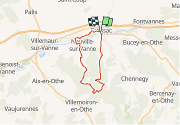
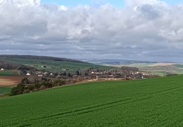
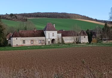
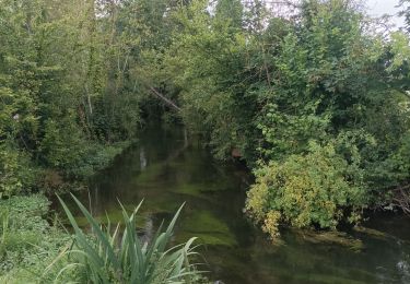
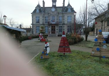
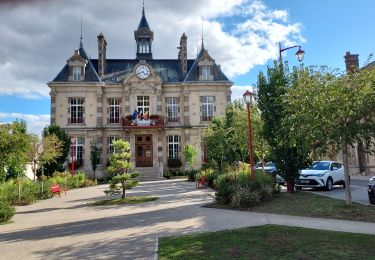
Randonnée Marche de 19,5 km à découvrir à Grand Est, Aube, Estissac. Cette randonnée est proposée par tracegps.
Description
Circuit proposé par l’Office de Tourisme du Pays d’Othe. Départ de la place de la salle des fêtes d'Estissac. Retrouvez ce circuit sur le site de l’Office du Tourisme. Ce circuit a été numérisé par les randonneurs du CODEPEM. Merci à Jean-Marie.
Localisation
Pays :
France
Région :
Grand Est
Département/Province :
Aube
Commune :
Estissac
Localité :
Unknown
Départ:(Dec)
Départ:(UTM)
559830 ; 5346331 (31U) N.
Commentaires
Randonnées à proximité
![Randonnée Marche Bucey-en-Othe - Au dessus de BUCEY EN OTHE - Photo](https://media.geolcdn.com/t/375/260/35008645-73de-4efb-a96c-d0d684570ae0.jpg&format=jpg&maxdim=2)
![Marche Marche](https://static1.geolcdn.com/sitytour/trail-icons/101.png)
Au dessus de BUCEY EN OTHE
Marche
Moyen
Bucey-en-Othe,
Grand Est,
Aube,
France
![](/images/other/stat-length.png)
9 km | 11,1 km-effort
2h 44min
![](https://static1.geolcdn.com/siteimages/upload/files/16400158638029165_repeat_loop_refresh_sync_direction_icon.png)
Oui
![Randonnée Marche Bucey-en-Othe - Bucey en Othe - Photo](https://media.geolcdn.com/t/375/260/5c3adecb-99f2-402f-8840-28b9ce614624.jpg&format=jpg&maxdim=2)
![Marche Marche](https://static1.geolcdn.com/sitytour/trail-icons/101.png)
Bucey en Othe
Marche
Difficile
Bucey-en-Othe,
Grand Est,
Aube,
France
![](/images/other/stat-length.png)
10 km | 12,6 km-effort
3h 0min
![](https://static1.geolcdn.com/siteimages/upload/files/16400158638029165_repeat_loop_refresh_sync_direction_icon.png)
Oui
![Randonnée Marche Chennegy - Randonnée à Chennegy - Photo](https://media.geolcdn.com/t/375/260/666caa5e-9668-4e17-9e4d-980944e36ad5.jpg&format=jpg&maxdim=2)
![Marche Marche](https://static1.geolcdn.com/sitytour/trail-icons/101.png)
Randonnée à Chennegy
Marche
Difficile
Chennegy,
Grand Est,
Aube,
France
![](/images/other/stat-length.png)
10,6 km | 12,4 km-effort
3h 5min
![](https://static1.geolcdn.com/siteimages/upload/files/16400158638029165_repeat_loop_refresh_sync_direction_icon.png)
Oui
![Randonnée Marche Bucey-en-Othe - Balade autour de Bicey - Photo](https://media.geolcdn.com/t/375/260/98615ad1-cbf1-4979-baef-35b7e1343f2e.jpg&format=jpg&maxdim=2)
![Marche Marche](https://static1.geolcdn.com/sitytour/trail-icons/101.png)
Balade autour de Bicey
Marche
Difficile
Bucey-en-Othe,
Grand Est,
Aube,
France
![](/images/other/stat-length.png)
9,6 km | 12,5 km-effort
2h 50min
![](https://static1.geolcdn.com/siteimages/upload/files/16400158638029165_repeat_loop_refresh_sync_direction_icon.png)
Oui
![Randonnée Marche Bucey-en-Othe - Bucey en Othe - Photo](https://media.geolcdn.com/t/375/260/3a00c592-7942-4888-b55e-9a28bdf9eb19.jpg&format=jpg&maxdim=2)
![Marche Marche](https://static1.geolcdn.com/sitytour/trail-icons/101.png)
Bucey en Othe
Marche
Moyen
Bucey-en-Othe,
Grand Est,
Aube,
France
![](/images/other/stat-length.png)
6,7 km | 8,6 km-effort
1h 46min
![](https://static1.geolcdn.com/siteimages/upload/files/16400158638029165_repeat_loop_refresh_sync_direction_icon.png)
Oui
![Randonnée Marche Estissac - Randonnée Bucey 01 août, 2023 - Photo](https://media.geolcdn.com/t/375/260/73372dab-7bdc-4eae-ba52-6410be568c17.jpg&format=jpg&maxdim=2)
![Marche Marche](https://static1.geolcdn.com/sitytour/trail-icons/101.png)
Randonnée Bucey 01 août, 2023
Marche
Moyen
Estissac,
Grand Est,
Aube,
France
![](/images/other/stat-length.png)
8,3 km | 9,4 km-effort
2h 13min
![](https://static1.geolcdn.com/siteimages/upload/files/16400158638029165_repeat_loop_refresh_sync_direction_icon.png)
Oui
![Randonnée Marche Estissac - Randonnée Club - Photo](https://media.geolcdn.com/t/375/260/3f183a86-fb71-4e1c-bc68-3aefbf52e304.jpg&format=jpg&maxdim=2)
![Marche Marche](https://static1.geolcdn.com/sitytour/trail-icons/101.png)
![Randonnée Vélo de route Estissac - EXT125 Estissac-01 - Photo](https://media.geolcdn.com/t/375/260/ac8a0968-d794-4f70-8e18-1fd419623ff1.jpg&format=jpg&maxdim=2)
![Vélo de route Vélo de route](https://static1.geolcdn.com/sitytour/trail-icons/201.png)
EXT125 Estissac-01
Vélo de route
Moyen
Estissac,
Grand Est,
Aube,
France
![](/images/other/stat-length.png)
126 km | 144 km-effort
6h 8min
![](https://static1.geolcdn.com/siteimages/upload/files/16400158638029165_repeat_loop_refresh_sync_direction_icon.png)
Oui
![Randonnée Marche Bucey-en-Othe - Au dessus de Bucey et Messon - Photo](https://media.geolcdn.com/t/375/260/60700a73-91d2-41e6-ac18-57bc0b49cc95.jpg&format=jpg&maxdim=2)
![Marche Marche](https://static1.geolcdn.com/sitytour/trail-icons/101.png)
Au dessus de Bucey et Messon
Marche
Moyen
Bucey-en-Othe,
Grand Est,
Aube,
France
![](/images/other/stat-length.png)
10,9 km | 13,5 km-effort
2h 47min
![](https://static1.geolcdn.com/siteimages/upload/files/16400158638029165_repeat_loop_refresh_sync_direction_icon.png)
Oui