![](/images/other/stat-length.png)
![Randonnée Marche Ossas-Suhare - Hegan Bürü - Ossas Suhare - Photo](https://media.geolcdn.com/t/1900/400/ext.pjpeg?maxdim=2&url=https%3A%2F%2Fservices.sitytrail.com%2FGeolivesWS%2FDownloadMedia.ashx%3FTrailID%3D111279%26Media%3D6911_1.jpg)
Hegan Bürü - Ossas Suhare
tracegps
Utilisateur
![Longueur](/images/other/stat-length.png)
Longueur
6,6 km
![Altitude max](https://static1.geolcdn.com/siteimages/upload/files/1508320355ic_sort_altitude_max_24dp.png)
Altitude max
309 m
![Dénivelé positif](https://static1.geolcdn.com/siteimages/upload/files/1508320355ic_sort_den_pos_24dp.png)
Dénivelé positif
188 m
![Km-Effort](/images/other/stat-length.png)
Km-Effort
8,9 km
![Altitude min](https://static1.geolcdn.com/siteimages/upload/files/1508320355ic_sort_altitude_min_24dp.png)
Altitude min
190 m
![Dénivelé négatif](https://static1.geolcdn.com/siteimages/upload/files/1508320355ic_sort_den_neg_24dp.png)
Dénivelé négatif
125 m
![Boucle](https://static1.geolcdn.com/siteimages/upload/files/16400158638029165_repeat_loop_refresh_sync_direction_icon.png)
Boucle
Non
Date de création :
2014-12-10 00:00:00.0
Dernière modification :
2014-12-10 00:00:00.0
![Marche](https://static1.geolcdn.com/sitytour/trail-icons/101.png)
3h30
Difficulté : Difficile
![Scannez ce code QR pour ouvrir la randonnée dans l'application SityTrail](https://capi.geolives.com/qq0zvz2zws4bq2lad0pu/sitytour/trails/111279/qr.png?size=200)
Application GPS de randonnée GRATUITE
À propos
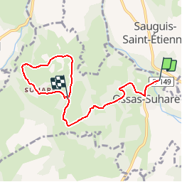
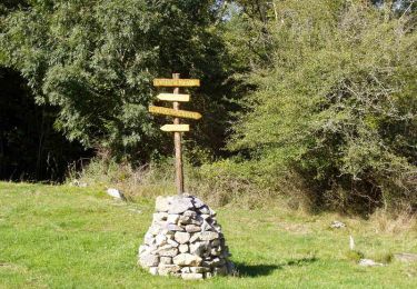
Randonnée Marche de 6,6 km à découvrir à Nouvelle-Aquitaine, Pyrénées-Atlantiques, Ossas-Suhare. Cette randonnée est proposée par tracegps.
Description
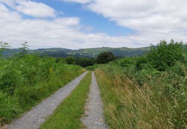
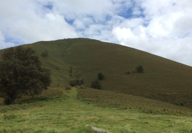
Promenade sur les coteaux dominants le Saison vers le village de Suhare comptant de belles maisons à l´architecture typique souletine. Retrouvez d’autres informations et la fiche descriptive sur le site Pays Basque et Béarn.
Localisation
Pays :
France
Région :
Nouvelle-Aquitaine
Département/Province :
Pyrénées-Atlantiques
Commune :
Ossas-Suhare
Localité :
Unknown
Départ:(Dec)
Départ:(UTM)
671739 ; 4778923 (30T) N.
Commentaires
Randonnées à proximité
![Randonnée Marche Ordiarp - ORDIARP la chapelle st Gregoire G3 4082977 - Photo](https://media.geolcdn.com/t/375/260/69f9a433-761a-4dab-85bf-268ab4f86849.jpg&format=jpg&maxdim=2)
![Marche Marche](https://static1.geolcdn.com/sitytour/trail-icons/101.png)
ORDIARP la chapelle st Gregoire G3 4082977
Marche
Difficile
Ordiarp,
Nouvelle-Aquitaine,
Pyrénées-Atlantiques,
France
![](/images/other/stat-length.png)
11,9 km | 17 km-effort
3h 28min
![](https://static1.geolcdn.com/siteimages/upload/files/16400158638029165_repeat_loop_refresh_sync_direction_icon.png)
Oui
![Randonnée Marche Ordiarp - ORDIARP le Kaskaborro G4 4079186 - Photo](https://media.geolcdn.com/t/375/260/71036ec1-6837-455a-bad4-847d1d3f0ecb.jpg&format=jpg&maxdim=2)
![Marche Marche](https://static1.geolcdn.com/sitytour/trail-icons/101.png)
ORDIARP le Kaskaborro G4 4079186
Marche
Difficile
Ordiarp,
Nouvelle-Aquitaine,
Pyrénées-Atlantiques,
France
![](/images/other/stat-length.png)
10,1 km | 13,4 km-effort
3h 6min
![](https://static1.geolcdn.com/siteimages/upload/files/16400158638029165_repeat_loop_refresh_sync_direction_icon.png)
Oui
![Randonnée A pied Ossas-Suhare - OSSAS SUHARE](https://media.geolcdn.com/t/375/260/bcbed15e-3fdc-48da-8ce1-ff916e49b92d.jpg&format=jpg&maxdim=2)
![A pied A pied](https://static1.geolcdn.com/sitytour/trail-icons/100.png)
OSSAS SUHARE "Heganbürü" balisage et reco (3721525)
A pied
Facile
Ossas-Suhare,
Nouvelle-Aquitaine,
Pyrénées-Atlantiques,
France
![](/images/other/stat-length.png)
9 km | 12,3 km-effort
2h 47min
![](https://static1.geolcdn.com/siteimages/upload/files/16400158638029165_repeat_loop_refresh_sync_direction_icon.png)
Oui
![Randonnée Marche Tardets-Sorholus - erretzü - Photo](https://media.geolcdn.com/t/375/260/ext.jpg?maxdim=2&url=https%3A%2F%2Fservices.sitytrail.com%2FGeolivesWS%2FDownloadMedia.ashx%3FTrailID%3D335416%26Media%3D20140816131403.jpg)
![Marche Marche](https://static1.geolcdn.com/sitytour/trail-icons/101.png)
erretzü
Marche
Très difficile
Tardets-Sorholus,
Nouvelle-Aquitaine,
Pyrénées-Atlantiques,
France
![](/images/other/stat-length.png)
10,8 km | 17,1 km-effort
4h 1min
![](https://static1.geolcdn.com/siteimages/upload/files/16400158638029165_repeat_loop_refresh_sync_direction_icon.png)
Oui
![Randonnée Marche Tardets-Sorholus - erretzü - Photo](https://media.geolcdn.com/t/375/260/ext.jpg?maxdim=2&url=https%3A%2F%2Fservices.sitytrail.com%2FGeolivesWS%2FDownloadMedia.ashx%3FTrailID%3D335409%26Media%3D20140816131403.jpg)
![Marche Marche](https://static1.geolcdn.com/sitytour/trail-icons/101.png)
erretzü
Marche
Très difficile
Tardets-Sorholus,
Nouvelle-Aquitaine,
Pyrénées-Atlantiques,
France
![](/images/other/stat-length.png)
10,8 km | 17,1 km-effort
4h 1min
![](https://static1.geolcdn.com/siteimages/upload/files/16400158638029165_repeat_loop_refresh_sync_direction_icon.png)
Oui
![Randonnée Marche Ossas-Suhare - ossas suhare G4FAIT - Photo](https://media.geolcdn.com/t/375/260/05de1fb1-9865-43b2-a20d-a59d71cd6157.jpg&format=jpg&maxdim=2)
![Marche Marche](https://static1.geolcdn.com/sitytour/trail-icons/101.png)
ossas suhare G4FAIT
Marche
Difficile
Ossas-Suhare,
Nouvelle-Aquitaine,
Pyrénées-Atlantiques,
France
![](/images/other/stat-length.png)
9 km | 12,2 km-effort
4h 57min
![](https://static1.geolcdn.com/siteimages/upload/files/16400158638029165_repeat_loop_refresh_sync_direction_icon.png)
Oui
![Randonnée Marche Camou-Cihigue - Sentiers des Lamiñaks - Camou - Cihigue - Photo](https://media.geolcdn.com/t/375/260/ext.jpg?maxdim=2&url=https%3A%2F%2Fservices.sitytrail.com%2FGeolivesWS%2FDownloadMedia.ashx%3FTrailID%3D104470%26Media%3D7749_6.jpg)
![Marche Marche](https://static1.geolcdn.com/sitytour/trail-icons/101.png)
Sentiers des Lamiñaks - Camou - Cihigue
Marche
Difficile
Camou-Cihigue,
Nouvelle-Aquitaine,
Pyrénées-Atlantiques,
France
![](/images/other/stat-length.png)
12,4 km | 21 km-effort
5h 30min
![](https://static1.geolcdn.com/siteimages/upload/files/16400158638029165_repeat_loop_refresh_sync_direction_icon.png)
Oui
![Randonnée Marche Ordiarp - fait - Photo](https://media.geolcdn.com/t/375/260/dc283403-16a2-429c-8cc1-dfe07b9af167.jpg&format=jpg&maxdim=2)
![Marche Marche](https://static1.geolcdn.com/sitytour/trail-icons/101.png)
fait
Marche
Difficile
Ordiarp,
Nouvelle-Aquitaine,
Pyrénées-Atlantiques,
France
![](/images/other/stat-length.png)
10,3 km | 13,6 km-effort
5h 49min
![](https://static1.geolcdn.com/siteimages/upload/files/16400158638029165_repeat_loop_refresh_sync_direction_icon.png)
Oui
![Randonnée Marche Sauguis-Saint-Étienne - Sauguis La Madeleine G3 GM - Photo](https://media.geolcdn.com/t/375/260/ext.jpg?maxdim=2&url=https%3A%2F%2Fstatic1.geolcdn.com%2Fsiteimages%2Fupload%2Ffiles%2F1553511878bg_sport_marche.png)
![Marche Marche](https://static1.geolcdn.com/sitytour/trail-icons/101.png)
Sauguis La Madeleine G3 GM
Marche
Très difficile
Sauguis-Saint-Étienne,
Nouvelle-Aquitaine,
Pyrénées-Atlantiques,
France
![](/images/other/stat-length.png)
11 km | 19,2 km-effort
4h 21min
![](https://static1.geolcdn.com/siteimages/upload/files/16400158638029165_repeat_loop_refresh_sync_direction_icon.png)
Oui