![](/images/other/stat-length.png)
![Randonnée Marche Fourneaux - Circuit de Fourneaux - C11-I - Photo](https://media.geolcdn.com/t/1900/400/ext.pjpeg?maxdim=2&url=https%3A%2F%2Fservices.sitytrail.com%2FGeolivesWS%2FDownloadMedia.ashx%3FTrailID%3D111261%26Media%3D6868_3.jpg)
Circuit de Fourneaux - C11-I
tracegps
Utilisateur
![Longueur](/images/other/stat-length.png)
Longueur
5,6 km
![Altitude max](https://static1.geolcdn.com/siteimages/upload/files/1508320355ic_sort_altitude_max_24dp.png)
Altitude max
97 m
![Dénivelé positif](https://static1.geolcdn.com/siteimages/upload/files/1508320355ic_sort_den_pos_24dp.png)
Dénivelé positif
98 m
![Km-Effort](/images/other/stat-length.png)
Km-Effort
6,9 km
![Altitude min](https://static1.geolcdn.com/siteimages/upload/files/1508320355ic_sort_altitude_min_24dp.png)
Altitude min
41 m
![Dénivelé négatif](https://static1.geolcdn.com/siteimages/upload/files/1508320355ic_sort_den_neg_24dp.png)
Dénivelé négatif
100 m
![Boucle](https://static1.geolcdn.com/siteimages/upload/files/16400158638029165_repeat_loop_refresh_sync_direction_icon.png)
Boucle
Oui
Date de création :
2014-12-10 00:00:00.0
Dernière modification :
2014-12-10 00:00:00.0
![Marche](https://static1.geolcdn.com/sitytour/trail-icons/101.png)
1h30
Difficulté : Facile
![Scannez ce code QR pour ouvrir la randonnée dans l'application SityTrail](https://capi.geolives.com/qq0zvz2zws4bq2lad0pu/sitytour/trails/111261/qr.png?size=200)
Application GPS de randonnée GRATUITE
À propos
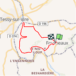
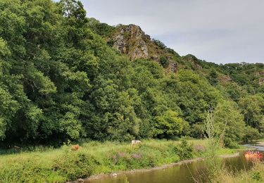
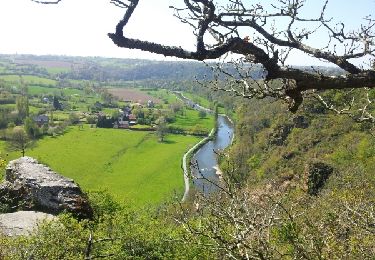
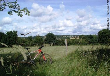
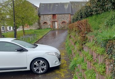
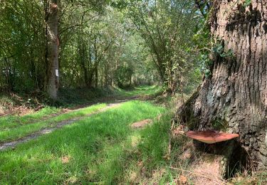
Randonnée Marche de 5,6 km à découvrir à Normandie, Manche, Fourneaux. Cette randonnée est proposée par tracegps.
Description
Circuit proposé par la Communauté de Communes de Tessy sur Vire. Départ de l’église de Fourneaux. Retrouvez le descriptif et les commentaires du circuit sur le site de la Communauté de Communes de Tessy sur Vire.
Localisation
Pays :
France
Région :
Normandie
Département/Province :
Manche
Commune :
Fourneaux
Localité :
Unknown
Départ:(Dec)
Départ:(UTM)
643733 ; 5425322 (30U) N.
Commentaires
Randonnées à proximité
![Randonnée Marche Condé-sur-Vire - Le rocher de Ham - Photo](https://media.geolcdn.com/t/375/260/8542ca5d-28d3-484e-89d2-e8c026fb9d47.jpg&format=jpg&maxdim=2)
![Marche Marche](https://static1.geolcdn.com/sitytour/trail-icons/101.png)
Le rocher de Ham
Marche
Facile
(1)
Condé-sur-Vire,
Normandie,
Manche,
France
![](/images/other/stat-length.png)
10,9 km | 13,4 km-effort
2h 24min
![](https://static1.geolcdn.com/siteimages/upload/files/16400158638029165_repeat_loop_refresh_sync_direction_icon.png)
Oui
![Randonnée Marche Condé-sur-Vire - Roches de ham - Photo](https://media.geolcdn.com/t/375/260/ext.jpg?maxdim=2&url=https%3A%2F%2Fservices.sitytrail.com%2FGeolivesWS%2FDownloadMedia.ashx%3FTrailID%3D267550%26Media%3Dfix__20140417152802.jpg)
![Marche Marche](https://static1.geolcdn.com/sitytour/trail-icons/101.png)
Roches de ham
Marche
Facile
(1)
Condé-sur-Vire,
Normandie,
Manche,
France
![](/images/other/stat-length.png)
11,1 km | 13,5 km-effort
2h 58min
![](https://static1.geolcdn.com/siteimages/upload/files/16400158638029165_repeat_loop_refresh_sync_direction_icon.png)
Oui
![Randonnée V.T.T. Domjean - Au coeur de la vallée de la Vire - Photo](https://media.geolcdn.com/t/375/260/ext.jpg?maxdim=2&url=https%3A%2F%2Fservices.sitytrail.com%2FGeolivesWS%2FDownloadMedia.ashx%3FTrailID%3D109294%26Media%3D3496_1.jpg)
![V.T.T. V.T.T.](https://static1.geolcdn.com/sitytour/trail-icons/202.png)
Au coeur de la vallée de la Vire
V.T.T.
Difficile
(2)
Domjean,
Normandie,
Manche,
France
![](/images/other/stat-length.png)
32 km | 39 km-effort
4h 0min
![](https://static1.geolcdn.com/siteimages/upload/files/16400158638029165_repeat_loop_refresh_sync_direction_icon.png)
Oui
![Randonnée Marche nordique Tessy-Bocage - rando haras pont farcy - Photo](https://media.geolcdn.com/t/375/260/3415af69-7f2b-496f-a8fd-837c9e113cab.jpg&format=jpg&maxdim=2)
![Marche nordique Marche nordique](https://static1.geolcdn.com/sitytour/trail-icons/102.png)
rando haras pont farcy
Marche nordique
Très facile
(1)
Tessy-Bocage,
Normandie,
Manche,
France
![](/images/other/stat-length.png)
9,9 km | 11,9 km-effort
2h 1min
![](https://static1.geolcdn.com/siteimages/upload/files/16400158638029165_repeat_loop_refresh_sync_direction_icon.png)
Non
![Randonnée Marche nordique Gouvets - rando eleanore - Photo](https://media.geolcdn.com/t/375/260/ext.jpg?maxdim=2&url=https%3A%2F%2Fstatic1.geolcdn.com%2Fsiteimages%2Fupload%2Ffiles%2F1545311037marcheuse_200dpi.jpg)
![Marche nordique Marche nordique](https://static1.geolcdn.com/sitytour/trail-icons/102.png)
rando eleanore
Marche nordique
Difficile
(1)
Gouvets,
Normandie,
Manche,
France
![](/images/other/stat-length.png)
11,1 km | 13,7 km-effort
2h 14min
![](https://static1.geolcdn.com/siteimages/upload/files/16400158638029165_repeat_loop_refresh_sync_direction_icon.png)
Oui
![Randonnée Marche Domjean - Rando gorge de la Vire - Photo](https://media.geolcdn.com/t/375/260/078dd238-3b4c-4f3c-9933-8f29f8ae0807.jpg&format=jpg&maxdim=2)
![Marche Marche](https://static1.geolcdn.com/sitytour/trail-icons/101.png)
Rando gorge de la Vire
Marche
Facile
Domjean,
Normandie,
Manche,
France
![](/images/other/stat-length.png)
35 km | 42 km-effort
10h 25min
![](https://static1.geolcdn.com/siteimages/upload/files/16400158638029165_repeat_loop_refresh_sync_direction_icon.png)
Oui
![Randonnée Marche Tessy-Bocage - Tessy-sur-Vire - C 13-V - Photo](https://media.geolcdn.com/t/375/260/ext.jpg?maxdim=2&url=https%3A%2F%2Fservices.sitytrail.com%2FGeolivesWS%2FDownloadMedia.ashx%3FTrailID%3D111302%26Media%3D6947_5.jpg)
![Marche Marche](https://static1.geolcdn.com/sitytour/trail-icons/101.png)
Tessy-sur-Vire - C 13-V
Marche
Facile
Tessy-Bocage,
Normandie,
Manche,
France
![](/images/other/stat-length.png)
3,4 km | 4,1 km-effort
1h 0min
![](https://static1.geolcdn.com/siteimages/upload/files/16400158638029165_repeat_loop_refresh_sync_direction_icon.png)
Oui
![Randonnée V.T.T. Tessy-Bocage - Tessy-sur-Vire - C 13-II - Photo](https://media.geolcdn.com/t/375/260/ext.jpg?maxdim=2&url=https%3A%2F%2Fservices.sitytrail.com%2FGeolivesWS%2FDownloadMedia.ashx%3FTrailID%3D111296%26Media%3D6939_4.jpg)
![V.T.T. V.T.T.](https://static1.geolcdn.com/sitytour/trail-icons/202.png)
Tessy-sur-Vire - C 13-II
V.T.T.
Facile
Tessy-Bocage,
Normandie,
Manche,
France
![](/images/other/stat-length.png)
8,8 km | 10,5 km-effort
1h 0min
![](https://static1.geolcdn.com/siteimages/upload/files/16400158638029165_repeat_loop_refresh_sync_direction_icon.png)
Oui
![Randonnée Marche Tessy-Bocage - Tessy-sur-Vire - C 13-II - Photo](https://media.geolcdn.com/t/375/260/ext.jpg?maxdim=2&url=https%3A%2F%2Fservices.sitytrail.com%2FGeolivesWS%2FDownloadMedia.ashx%3FTrailID%3D111295%26Media%3D6939_4.jpg)
![Marche Marche](https://static1.geolcdn.com/sitytour/trail-icons/101.png)
Tessy-sur-Vire - C 13-II
Marche
Moyen
Tessy-Bocage,
Normandie,
Manche,
France
![](/images/other/stat-length.png)
8,8 km | 10,5 km-effort
2h 15min
![](https://static1.geolcdn.com/siteimages/upload/files/16400158638029165_repeat_loop_refresh_sync_direction_icon.png)
Oui