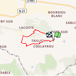
![](/images/other/stat-length.png)
![Randonnée Marche Villeneuve-sur-Lot - Saint-Germain, aux portes de Villeneuve-sur-lot - Pays de la vallée du Lot - Photo](https://media.geolcdn.com/t/1900/400/ext.pjpeg?maxdim=2&url=https%3A%2F%2Fservices.sitytrail.com%2FGeolivesWS%2FDownloadMedia.ashx%3FTrailID%3D111112%26Media%3D6456_1.jpg)
Saint-Germain, aux portes de Villeneuve-sur-lot - Pays de la vallée du Lot
tracegps
Utilisateur
![Longueur](/images/other/stat-length.png)
![Altitude max](https://static1.geolcdn.com/siteimages/upload/files/1508320355ic_sort_altitude_max_24dp.png)
![Dénivelé positif](https://static1.geolcdn.com/siteimages/upload/files/1508320355ic_sort_den_pos_24dp.png)
![Km-Effort](/images/other/stat-length.png)
![Altitude min](https://static1.geolcdn.com/siteimages/upload/files/1508320355ic_sort_altitude_min_24dp.png)
![Dénivelé négatif](https://static1.geolcdn.com/siteimages/upload/files/1508320355ic_sort_den_neg_24dp.png)
![Boucle](https://static1.geolcdn.com/siteimages/upload/files/16400158638029165_repeat_loop_refresh_sync_direction_icon.png)
![Marche](https://static1.geolcdn.com/sitytour/trail-icons/101.png)
1h19
Difficulté : Facile
![Scannez ce code QR pour ouvrir la randonnée dans l'application SityTrail](https://capi.geolives.com/qq0zvz2zws4bq2lad0pu/sitytour/trails/111112/qr.png?size=200)
Application GPS de randonnée GRATUITE
À propos
Randonnée Marche de 4,2 km à découvrir à Nouvelle-Aquitaine, Lot-et-Garonne, Villeneuve-sur-Lot. Cette randonnée est proposée par tracegps.
Description
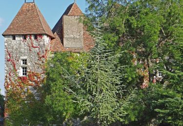
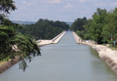
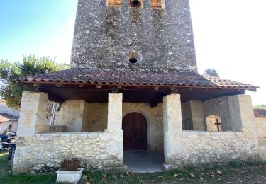
St Germain Commune de Villeneuve sur Lot C. C. du Villeneuvois. Cette petite boucle nature se cache dans les coteaux escarpés du Pays de Serres, rive gauche du Lot. Une bande boisée masque d’ailleurs la vallée, offrant calme et détente aux résidents et aux promeneurs et pèlerins qui marchent vers Saint-Jacques de Compostelle. Téléchargez la fiche de cette randonnée sur le site du Tourisme du Lot et Garonne.
Localisation
Commentaires
Randonnées à proximité
![Randonnée Marche Pujols - Cambes, un circuit autour d'une combe boisée - Pays de la vallée du Lot - Photo](https://media.geolcdn.com/t/375/260/ext.jpg?maxdim=2&url=https%3A%2F%2Fservices.sitytrail.com%2FGeolivesWS%2FDownloadMedia.ashx%3FTrailID%3D111067%26Media%3D6432_1.jpg)
![Marche Marche](https://static1.geolcdn.com/sitytour/trail-icons/101.png)
Marche
![](/images/other/stat-length.png)
![](https://static1.geolcdn.com/siteimages/upload/files/16400158638029165_repeat_loop_refresh_sync_direction_icon.png)
![Randonnée Marche Hautefage-la-Tour - Bonneval, le circuit des trois églises - Pays de la vallée du Lot - Photo](https://media.geolcdn.com/t/375/260/ext.jpg?maxdim=2&url=https%3A%2F%2Fservices.sitytrail.com%2FGeolivesWS%2FDownloadMedia.ashx%3FTrailID%3D110835%26Media%3D6309_1.jpg)
![Marche Marche](https://static1.geolcdn.com/sitytour/trail-icons/101.png)
Marche
![](/images/other/stat-length.png)
![](https://static1.geolcdn.com/siteimages/upload/files/16400158638029165_repeat_loop_refresh_sync_direction_icon.png)
![Randonnée A pied Hautefage-la-Tour - Saint-Thomas, par Saint-Just et Piquepoul - 10.6 km - Photo](https://media.geolcdn.com/t/375/260/0159e0b0-0768-4fb0-bf01-e950449d9ffd.jpeg&format=jpg&maxdim=2)
![A pied A pied](https://static1.geolcdn.com/sitytour/trail-icons/100.png)
A pied
![](/images/other/stat-length.png)
![](https://static1.geolcdn.com/siteimages/upload/files/16400158638029165_repeat_loop_refresh_sync_direction_icon.png)
![Randonnée A pied Saint-Antoine-de-Ficalba - Bonneval, le circuit des trois églises - 10,7km - Photo](https://media.geolcdn.com/t/375/260/0159e0b0-0768-4fb0-bf01-e950449d9ffd.jpeg&format=jpg&maxdim=2)
![A pied A pied](https://static1.geolcdn.com/sitytour/trail-icons/100.png)
A pied
![](/images/other/stat-length.png)
![](https://static1.geolcdn.com/siteimages/upload/files/16400158638029165_repeat_loop_refresh_sync_direction_icon.png)
![Randonnée A pied Penne-d'Agenais - Penne-d’Agenais, vers le château de Noaillac - 13,2km - Photo](https://media.geolcdn.com/t/375/260/ab1b4457-776f-4293-97bf-e8d308314e23.jpeg&format=jpg&maxdim=2)
![A pied A pied](https://static1.geolcdn.com/sitytour/trail-icons/100.png)
A pied
![](/images/other/stat-length.png)
![](https://static1.geolcdn.com/siteimages/upload/files/16400158638029165_repeat_loop_refresh_sync_direction_icon.png)
![Randonnée V.T.T. Penne-d'Agenais - Penne-d'agenais côteaux du Boudouyssou - Photo](https://media.geolcdn.com/t/375/260/ext.jpg?maxdim=2&url=https%3A%2F%2Fstatic1.geolcdn.com%2Fsiteimages%2Fupload%2Ffiles%2F1524743154velo.jpg)
![V.T.T. V.T.T.](https://static1.geolcdn.com/sitytour/trail-icons/202.png)
V.T.T.
![](/images/other/stat-length.png)
![](https://static1.geolcdn.com/siteimages/upload/files/16400158638029165_repeat_loop_refresh_sync_direction_icon.png)
![Randonnée Vélo Villeneuve-sur-Lot - de Villeneuve sur Lot à Moissac en passant par Aiguillon - Photo](https://media.geolcdn.com/t/375/260/ext.jpg?maxdim=2&url=https%3A%2F%2Fservices.sitytrail.com%2FGeolivesWS%2FDownloadMedia.ashx%3FTrailID%3D588391%26Media%3Df4638f96-87eb-466a-9d9d-69a168ebcbb2.JPG)
![Vélo Vélo](https://static1.geolcdn.com/sitytour/trail-icons/200.png)
Vélo
![](/images/other/stat-length.png)
![](https://static1.geolcdn.com/siteimages/upload/files/16400158638029165_repeat_loop_refresh_sync_direction_icon.png)
![Randonnée Marche Pujols - Cambes Pujols - Photo](https://media.geolcdn.com/t/375/260/e50c9e7e-2a48-47aa-8b6d-475985980a6b.jpg&format=jpg&maxdim=2)
![Marche Marche](https://static1.geolcdn.com/sitytour/trail-icons/101.png)
Marche
![](/images/other/stat-length.png)
![](https://static1.geolcdn.com/siteimages/upload/files/16400158638029165_repeat_loop_refresh_sync_direction_icon.png)
![Randonnée A pied Auradou - Penne-d’Agenais, Auradou, dans les coteaux nord du Pays de Serres - 23km - Photo](https://media.geolcdn.com/t/375/260/ext.jpg?maxdim=2&url=https%3A%2F%2Fstatic1.geolcdn.com%2Fsiteimages%2Fupload%2Ffiles%2F1545311037marcheuse_200dpi.jpg)
![A pied A pied](https://static1.geolcdn.com/sitytour/trail-icons/100.png)
A pied
![](/images/other/stat-length.png)
![](https://static1.geolcdn.com/siteimages/upload/files/16400158638029165_repeat_loop_refresh_sync_direction_icon.png)