![](/images/other/stat-length.png)
![Randonnée Marche Montayral - Montayral, dans les Combes de Bazérac et d'Escure - Pays de la vallée du Lot - Photo](https://media.geolcdn.com/t/1900/400/ext.pjpeg?maxdim=2&url=https%3A%2F%2Fservices.sitytrail.com%2FGeolivesWS%2FDownloadMedia.ashx%3FTrailID%3D111031%26Media%3D6417_1.jpg)
Montayral, dans les Combes de Bazérac et d'Escure - Pays de la vallée du Lot
tracegps
Utilisateur
![Longueur](/images/other/stat-length.png)
Longueur
9,5 km
![Altitude max](https://static1.geolcdn.com/siteimages/upload/files/1508320355ic_sort_altitude_max_24dp.png)
Altitude max
228 m
![Dénivelé positif](https://static1.geolcdn.com/siteimages/upload/files/1508320355ic_sort_den_pos_24dp.png)
Dénivelé positif
274 m
![Km-Effort](/images/other/stat-length.png)
Km-Effort
13,2 km
![Altitude min](https://static1.geolcdn.com/siteimages/upload/files/1508320355ic_sort_altitude_min_24dp.png)
Altitude min
120 m
![Dénivelé négatif](https://static1.geolcdn.com/siteimages/upload/files/1508320355ic_sort_den_neg_24dp.png)
Dénivelé négatif
276 m
![Boucle](https://static1.geolcdn.com/siteimages/upload/files/16400158638029165_repeat_loop_refresh_sync_direction_icon.png)
Boucle
Oui
Date de création :
2014-12-10 00:00:00.0
Dernière modification :
2014-12-10 00:00:00.0
![Marche](https://static1.geolcdn.com/sitytour/trail-icons/101.png)
2h30
Difficulté : Moyen
![Scannez ce code QR pour ouvrir la randonnée dans l'application SityTrail](https://capi.geolives.com/qq0zvz2zws4bq2lad0pu/sitytour/trails/111031/qr.png?size=200)
Application GPS de randonnée GRATUITE
À propos
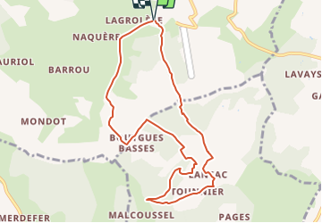
Randonnée Marche de 9,5 km à découvrir à Nouvelle-Aquitaine, Lot-et-Garonne, Montayral. Cette randonnée est proposée par tracegps.
Description
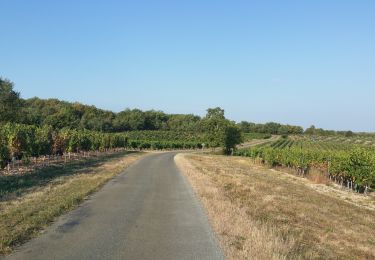
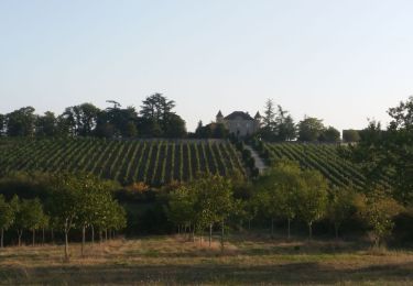
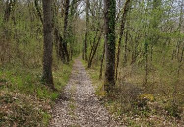
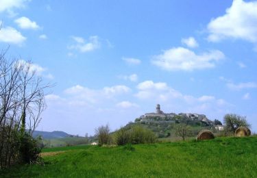
Montayral / Bazérac Cté de Communes Fumélois Lémance. Vergers de pruniers d’Ente et vignobles alternent avec les combes boisées et les pechs arides des portes du Quercy. Téléchargez la fiche de cette randonnée sur le site du Tourisme du Lot et Garonne.
Localisation
Pays :
France
Région :
Nouvelle-Aquitaine
Département/Province :
Lot-et-Garonne
Commune :
Montayral
Localité :
Unknown
Départ:(Dec)
Départ:(UTM)
340967 ; 4925336 (31T) N.
Commentaires
Randonnées à proximité
![Randonnée Cheval Fumel - Le GR de pays du château de Fumel au château de Bonaguil - Photo](https://media.geolcdn.com/t/375/260/ext.jpg?maxdim=2&url=https%3A%2F%2Fservices.sitytrail.com%2FGeolivesWS%2FDownloadMedia.ashx%3FTrailID%3D318090%26Media%3D17548_5.jpg)
![Cheval Cheval](https://static1.geolcdn.com/sitytour/trail-icons/300.png)
Le GR de pays du château de Fumel au château de Bonaguil
Cheval
Facile
Fumel,
Nouvelle-Aquitaine,
Lot-et-Garonne,
France
![](/images/other/stat-length.png)
9,4 km | 12,1 km-effort
1h 40min
![](https://static1.geolcdn.com/siteimages/upload/files/16400158638029165_repeat_loop_refresh_sync_direction_icon.png)
Non
![Randonnée V.T.T. Fumel - Le GR de pays du château de Fumel au château de Bonaguil - Photo](https://media.geolcdn.com/t/375/260/ext.jpg?maxdim=2&url=https%3A%2F%2Fservices.sitytrail.com%2FGeolivesWS%2FDownloadMedia.ashx%3FTrailID%3D318089%26Media%3D17548_4.jpg)
![V.T.T. V.T.T.](https://static1.geolcdn.com/sitytour/trail-icons/202.png)
Le GR de pays du château de Fumel au château de Bonaguil
V.T.T.
Facile
(1)
Fumel,
Nouvelle-Aquitaine,
Lot-et-Garonne,
France
![](/images/other/stat-length.png)
9,4 km | 12,1 km-effort
1h 15min
![](https://static1.geolcdn.com/siteimages/upload/files/16400158638029165_repeat_loop_refresh_sync_direction_icon.png)
Non
![Randonnée Marche Fumel - Le GR de pays du château de Fumel au château de Bonaguil - Photo](https://media.geolcdn.com/t/375/260/ext.jpg?maxdim=2&url=https%3A%2F%2Fservices.sitytrail.com%2FGeolivesWS%2FDownloadMedia.ashx%3FTrailID%3D318088%26Media%3D17548_5.jpg)
![Marche Marche](https://static1.geolcdn.com/sitytour/trail-icons/101.png)
Le GR de pays du château de Fumel au château de Bonaguil
Marche
Moyen
Fumel,
Nouvelle-Aquitaine,
Lot-et-Garonne,
France
![](/images/other/stat-length.png)
9,4 km | 12,1 km-effort
2h 30min
![](https://static1.geolcdn.com/siteimages/upload/files/16400158638029165_repeat_loop_refresh_sync_direction_icon.png)
Non
![Randonnée Moteur Fumel - Fumel circuit voiture - Photo](https://media.geolcdn.com/t/375/260/ext.jpg?maxdim=2&url=https%3A%2F%2Fstatic1.geolcdn.com%2Fsiteimages%2Fupload%2Ffiles%2F15247431544x4.jpg)
![Moteur Moteur](https://static1.geolcdn.com/sitytour/trail-icons/400.png)
Fumel circuit voiture
Moteur
Facile
(1)
Fumel,
Nouvelle-Aquitaine,
Lot-et-Garonne,
France
![](/images/other/stat-length.png)
84 km | 104 km-effort
7h 0min
![](https://static1.geolcdn.com/siteimages/upload/files/16400158638029165_repeat_loop_refresh_sync_direction_icon.png)
Oui
![Randonnée Cyclotourisme Mauroux - Mauroux, Puy l'évêque - Photo](https://media.geolcdn.com/t/375/260/ext.jpg?maxdim=2&url=https%3A%2F%2Fmedia.geolcdn.com%2Ff%2F5cd0f26c-c3bb-46d4-a8e5-7058916c2b6b.jpg)
![Cyclotourisme Cyclotourisme](https://static1.geolcdn.com/sitytour/trail-icons/204.png)
Mauroux, Puy l'évêque
Cyclotourisme
Facile
Mauroux,
Occitanie,
Lot,
France
![](/images/other/stat-length.png)
24 km | 28 km-effort
1h 40min
![](https://static1.geolcdn.com/siteimages/upload/files/16400158638029165_repeat_loop_refresh_sync_direction_icon.png)
Oui
![Randonnée Cyclotourisme Mauroux - Mauroux - Photo](https://media.geolcdn.com/t/375/260/ext.jpg?maxdim=2&url=https%3A%2F%2Fmedia.geolcdn.com%2Ff%2F341f9145-1bf2-4f12-8011-f8c70f66b7a3.jpg)
![Cyclotourisme Cyclotourisme](https://static1.geolcdn.com/sitytour/trail-icons/204.png)
![Randonnée Marche Thézac - thezac - Photo](https://media.geolcdn.com/t/375/260/ext.jpg?maxdim=2&url=https%3A%2F%2Fmedia.geolcdn.com%2Ff%2Fecbb94b5-e871-4132-8039-983679d127d9.jpg)
![Marche Marche](https://static1.geolcdn.com/sitytour/trail-icons/101.png)
thezac
Marche
Très facile
(1)
Thézac,
Nouvelle-Aquitaine,
Lot-et-Garonne,
France
![](/images/other/stat-length.png)
11,6 km | 15,2 km-effort
2h 38min
![](https://static1.geolcdn.com/siteimages/upload/files/16400158638029165_repeat_loop_refresh_sync_direction_icon.png)
Oui
![Randonnée V.T.T. Thézac - VTT autour de Thézac - Photo](https://media.geolcdn.com/t/375/260/ext.jpg?maxdim=2&url=https%3A%2F%2Fservices.sitytrail.com%2FGeolivesWS%2FDownloadMedia.ashx%3FTrailID%3D191516%26Media%3D15116_1.jpg)
![V.T.T. V.T.T.](https://static1.geolcdn.com/sitytour/trail-icons/202.png)
VTT autour de Thézac
V.T.T.
Difficile
Thézac,
Nouvelle-Aquitaine,
Lot-et-Garonne,
France
![](/images/other/stat-length.png)
30 km | 37 km-effort
2h 30min
![](https://static1.geolcdn.com/siteimages/upload/files/16400158638029165_repeat_loop_refresh_sync_direction_icon.png)
Oui
![Randonnée V.T.T. Thézac - Thézac, balade dans les coteaux du Quercy - Pays de la vallée du Lot - Photo](https://media.geolcdn.com/t/375/260/ext.jpg?maxdim=2&url=https%3A%2F%2Fservices.sitytrail.com%2FGeolivesWS%2FDownloadMedia.ashx%3FTrailID%3D111097%26Media%3D6449_1.jpg)
![V.T.T. V.T.T.](https://static1.geolcdn.com/sitytour/trail-icons/202.png)
Thézac, balade dans les coteaux du Quercy - Pays de la vallée du Lot
V.T.T.
Facile
Thézac,
Nouvelle-Aquitaine,
Lot-et-Garonne,
France
![](/images/other/stat-length.png)
5,2 km | 6,9 km-effort
40min
![](https://static1.geolcdn.com/siteimages/upload/files/16400158638029165_repeat_loop_refresh_sync_direction_icon.png)
Oui