![](/images/other/stat-length.png)
![Randonnée Marche Long - Longue promenade dans les marais de Long - Photo](https://media.geolcdn.com/t/1900/400/ext.pjpeg?maxdim=2&url=https%3A%2F%2Fservices.sitytrail.com%2FGeolivesWS%2FDownloadMedia.ashx%3FTrailID%3D110477%26Media%3D5992_6.jpg)
Longue promenade dans les marais de Long
tracegps
Utilisateur
![Longueur](/images/other/stat-length.png)
Longueur
13 km
![Altitude max](https://static1.geolcdn.com/siteimages/upload/files/1508320355ic_sort_altitude_max_24dp.png)
Altitude max
17 m
![Dénivelé positif](https://static1.geolcdn.com/siteimages/upload/files/1508320355ic_sort_den_pos_24dp.png)
Dénivelé positif
67 m
![Km-Effort](/images/other/stat-length.png)
Km-Effort
13,9 km
![Altitude min](https://static1.geolcdn.com/siteimages/upload/files/1508320355ic_sort_altitude_min_24dp.png)
Altitude min
4 m
![Dénivelé négatif](https://static1.geolcdn.com/siteimages/upload/files/1508320355ic_sort_den_neg_24dp.png)
Dénivelé négatif
67 m
![Boucle](https://static1.geolcdn.com/siteimages/upload/files/16400158638029165_repeat_loop_refresh_sync_direction_icon.png)
Boucle
Oui
Date de création :
2014-12-10 00:00:00.0
Dernière modification :
2014-12-10 00:00:00.0
![Marche](https://static1.geolcdn.com/sitytour/trail-icons/101.png)
3h15
Difficulté : Difficile
![Scannez ce code QR pour ouvrir la randonnée dans l'application SityTrail](https://capi.geolives.com/qq0zvz2zws4bq2lad0pu/sitytour/trails/110477/qr.png?size=200)
Application GPS de randonnée GRATUITE
À propos
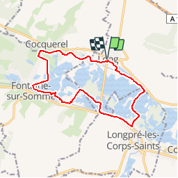
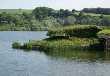
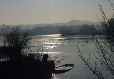
Randonnée Marche de 13 km à découvrir à Hauts-de-France, Somme, Long. Cette randonnée est proposée par tracegps.
Description
Circuit proposé par l’Office de Tourisme de Long. Départ de la mairie de Long. Retrouvez le descriptif de l’ensemble des circuits sur le site de l’Office de Tourisme de Long. Ce circuit a été numérisé par les randonneurs du CODEPEM. Merci à Jean-Marie.
Localisation
Pays :
France
Région :
Hauts-de-France
Département/Province :
Somme
Commune :
Long
Localité :
Unknown
Départ:(Dec)
Départ:(UTM)
426870 ; 5543475 (31U) N.
Commentaires
Randonnées à proximité
![Randonnée Marche Long - L'écluse et la centrale hydroélectrique - Long - Photo](https://media.geolcdn.com/t/375/260/ext.jpg?maxdim=2&url=https%3A%2F%2Fservices.sitytrail.com%2FGeolivesWS%2FDownloadMedia.ashx%3FTrailID%3D110473%26Media%3D5989_6.jpg)
![Marche Marche](https://static1.geolcdn.com/sitytour/trail-icons/101.png)
L'écluse et la centrale hydroélectrique - Long
Marche
Facile
(1)
Long,
Hauts-de-France,
Somme,
France
![](/images/other/stat-length.png)
2,4 km | 2,6 km-effort
30min
![](https://static1.geolcdn.com/siteimages/upload/files/16400158638029165_repeat_loop_refresh_sync_direction_icon.png)
Oui
![Randonnée Marche Long - long bleue 9km - Photo](https://media.geolcdn.com/t/375/260/89b8b5e6-56c9-4922-964d-87c8f198f560.jpg&format=jpg&maxdim=2)
![Marche Marche](https://static1.geolcdn.com/sitytour/trail-icons/101.png)
long bleue 9km
Marche
Moyen
Long,
Hauts-de-France,
Somme,
France
![](/images/other/stat-length.png)
9,4 km | 10,2 km-effort
2h 3min
![](https://static1.geolcdn.com/siteimages/upload/files/16400158638029165_repeat_loop_refresh_sync_direction_icon.png)
Non
![Randonnée A pied Condé-Folie - Les Marais de Condé-Folie - Photo](https://media.geolcdn.com/t/375/260/835fcbd3-aace-47a4-b88d-70695e4b8706.jpeg&format=jpg&maxdim=2)
![A pied A pied](https://static1.geolcdn.com/sitytour/trail-icons/100.png)
Les Marais de Condé-Folie
A pied
Facile
Condé-Folie,
Hauts-de-France,
Somme,
France
![](/images/other/stat-length.png)
5,4 km | 5,7 km-effort
1h 18min
![](https://static1.geolcdn.com/siteimages/upload/files/16400158638029165_repeat_loop_refresh_sync_direction_icon.png)
Oui
![Randonnée A pied Longpré-les-Corps-Saints - Le Circuit des Cours d'Eau - Photo](https://media.geolcdn.com/t/375/260/0092ca74-c815-4988-81a6-9840359e6184.jpeg&format=jpg&maxdim=2)
![A pied A pied](https://static1.geolcdn.com/sitytour/trail-icons/100.png)
Le Circuit des Cours d'Eau
A pied
Facile
Longpré-les-Corps-Saints,
Hauts-de-France,
Somme,
France
![](/images/other/stat-length.png)
4,9 km | 5,2 km-effort
1h 11min
![](https://static1.geolcdn.com/siteimages/upload/files/16400158638029165_repeat_loop_refresh_sync_direction_icon.png)
Oui
![Randonnée A pied Long - Les Bords de Somme - Photo](https://media.geolcdn.com/t/375/260/524a8fde-e553-41eb-af37-bc359713a178.jpeg&format=jpg&maxdim=2)
![A pied A pied](https://static1.geolcdn.com/sitytour/trail-icons/100.png)
Les Bords de Somme
A pied
Facile
Long,
Hauts-de-France,
Somme,
France
![](/images/other/stat-length.png)
7,9 km | 8,4 km-effort
1h 54min
![](https://static1.geolcdn.com/siteimages/upload/files/16400158638029165_repeat_loop_refresh_sync_direction_icon.png)
Oui
![Randonnée A pied Fontaine-sur-Somme - Les Hauts de Long - Photo](https://media.geolcdn.com/t/375/260/857ea661-13e1-4088-8b62-d697c76652e3.jpeg&format=jpg&maxdim=2)
![A pied A pied](https://static1.geolcdn.com/sitytour/trail-icons/100.png)
Les Hauts de Long
A pied
Facile
Fontaine-sur-Somme,
Hauts-de-France,
Somme,
France
![](/images/other/stat-length.png)
9,1 km | 11 km-effort
2h 29min
![](https://static1.geolcdn.com/siteimages/upload/files/16400158638029165_repeat_loop_refresh_sync_direction_icon.png)
Oui
![Randonnée Marche Long - Une randonnée rythmée par les étangs. - Photo](https://media.geolcdn.com/t/375/260/07cc8282-85e0-46da-9260-ab7cedc0be52.jpg&format=jpg&maxdim=2)
![Marche Marche](https://static1.geolcdn.com/sitytour/trail-icons/101.png)
Une randonnée rythmée par les étangs.
Marche
Très facile
Long,
Hauts-de-France,
Somme,
France
![](/images/other/stat-length.png)
6,7 km | 7,1 km-effort
1h 53min
![](https://static1.geolcdn.com/siteimages/upload/files/16400158638029165_repeat_loop_refresh_sync_direction_icon.png)
Non
![Randonnée Marche Longpré-les-Corps-Saints - Le circuit des cours d'eau - Longpré les Corps Saints - Photo](https://media.geolcdn.com/t/375/260/ext.jpg?maxdim=2&url=https%3A%2F%2Fservices.sitytrail.com%2FGeolivesWS%2FDownloadMedia.ashx%3FTrailID%3D173255%26Media%3D14869_3.jpg)
![Marche Marche](https://static1.geolcdn.com/sitytour/trail-icons/101.png)
Le circuit des cours d'eau - Longpré les Corps Saints
Marche
Moyen
(1)
Longpré-les-Corps-Saints,
Hauts-de-France,
Somme,
France
![](/images/other/stat-length.png)
4,9 km | 5,2 km-effort
1h 30min
![](https://static1.geolcdn.com/siteimages/upload/files/16400158638029165_repeat_loop_refresh_sync_direction_icon.png)
Oui
![Randonnée V.T.T. Long - Circuit autour de Long - Photo](https://media.geolcdn.com/t/375/260/ext.jpg?maxdim=2&url=https%3A%2F%2Fservices.sitytrail.com%2FGeolivesWS%2FDownloadMedia.ashx%3FTrailID%3D110555%26Media%3D6111_6.jpg)
![V.T.T. V.T.T.](https://static1.geolcdn.com/sitytour/trail-icons/202.png)
Circuit autour de Long
V.T.T.
Difficile
Long,
Hauts-de-France,
Somme,
France
![](/images/other/stat-length.png)
30 km | 35 km-effort
3h 0min
![](https://static1.geolcdn.com/siteimages/upload/files/16400158638029165_repeat_loop_refresh_sync_direction_icon.png)
Oui