![](/images/other/stat-length.png)
![Randonnée Marche Bonnétable - Bonnétable - Fleurs ou légumes...13km - Photo](https://media.geolcdn.com/t/1900/400/ext.pjpeg?maxdim=2&url=https%3A%2F%2Fservices.sitytrail.com%2FGeolivesWS%2FDownloadMedia.ashx%3FTrailID%3D110454%26Media%3D5949_1.jpg)
Bonnétable - Fleurs ou légumes...13km
tracegps
Utilisateur
![Longueur](/images/other/stat-length.png)
Longueur
12,6 km
![Altitude max](https://static1.geolcdn.com/siteimages/upload/files/1508320355ic_sort_altitude_max_24dp.png)
Altitude max
147 m
![Dénivelé positif](https://static1.geolcdn.com/siteimages/upload/files/1508320355ic_sort_den_pos_24dp.png)
Dénivelé positif
114 m
![Km-Effort](/images/other/stat-length.png)
Km-Effort
14,1 km
![Altitude min](https://static1.geolcdn.com/siteimages/upload/files/1508320355ic_sort_altitude_min_24dp.png)
Altitude min
96 m
![Dénivelé négatif](https://static1.geolcdn.com/siteimages/upload/files/1508320355ic_sort_den_neg_24dp.png)
Dénivelé négatif
116 m
![Boucle](https://static1.geolcdn.com/siteimages/upload/files/16400158638029165_repeat_loop_refresh_sync_direction_icon.png)
Boucle
Oui
Date de création :
2014-12-10 00:00:00.0
Dernière modification :
2014-12-10 00:00:00.0
![Marche](https://static1.geolcdn.com/sitytour/trail-icons/101.png)
2h10
Difficulté : Moyen
![Scannez ce code QR pour ouvrir la randonnée dans l'application SityTrail](https://capi.geolives.com/qq0zvz2zws4bq2lad0pu/sitytour/trails/110454/qr.png?size=200)
Application GPS de randonnée GRATUITE
À propos
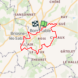
Randonnée Marche de 12,6 km à découvrir à Pays de la Loire, Sarthe, Bonnétable. Cette randonnée est proposée par tracegps.
Description
Bonnétable - Fleurs ou légumes…13km A la découverte des trésors cachés du Perche Sarthois. Variante ; après le chemin de « la Brancherie », prendre à gauche en direction du , passer par la « Petite Cannetière », ensuite le « chemin de Citeaux » et retour.
Localisation
Pays :
France
Région :
Pays de la Loire
Département/Province :
Sarthe
Commune :
Bonnétable
Localité :
Unknown
Départ:(Dec)
Départ:(UTM)
308687 ; 5339147 (31U) N.
Commentaires
Randonnées à proximité
![Randonnée Marche Bonnétable - la vive parence - Photo](https://media.geolcdn.com/t/375/260/ext.jpg?maxdim=2&url=https%3A%2F%2Fstatic1.geolcdn.com%2Fsiteimages%2Fupload%2Ffiles%2F1553511878bg_sport_marche.png)
![Marche Marche](https://static1.geolcdn.com/sitytour/trail-icons/101.png)
la vive parence
Marche
Facile
(1)
Bonnétable,
Pays de la Loire,
Sarthe,
France
![](/images/other/stat-length.png)
10 km | 11,5 km-effort
2h 36min
![](https://static1.geolcdn.com/siteimages/upload/files/16400158638029165_repeat_loop_refresh_sync_direction_icon.png)
Oui
![Randonnée Marche Bonnétable - Bonnétable - Fleurs ou légumes...15km - Photo](https://media.geolcdn.com/t/375/260/ext.jpg?maxdim=2&url=https%3A%2F%2Fservices.sitytrail.com%2FGeolivesWS%2FDownloadMedia.ashx%3FTrailID%3D110455%26Media%3D5950_1.jpg)
![Marche Marche](https://static1.geolcdn.com/sitytour/trail-icons/101.png)
Bonnétable - Fleurs ou légumes...15km
Marche
Moyen
Bonnétable,
Pays de la Loire,
Sarthe,
France
![](/images/other/stat-length.png)
15,1 km | 17,5 km-effort
2h 30min
![](https://static1.geolcdn.com/siteimages/upload/files/16400158638029165_repeat_loop_refresh_sync_direction_icon.png)
Oui
![Randonnée Marche Bonnétable - Bonnétable - Fleurs ou légumes...18km - Photo](https://media.geolcdn.com/t/375/260/ext.jpg?maxdim=2&url=https%3A%2F%2Fservices.sitytrail.com%2FGeolivesWS%2FDownloadMedia.ashx%3FTrailID%3D110453%26Media%3D5948_1.jpg)
![Marche Marche](https://static1.geolcdn.com/sitytour/trail-icons/101.png)
Bonnétable - Fleurs ou légumes...18km
Marche
Moyen
Bonnétable,
Pays de la Loire,
Sarthe,
France
![](/images/other/stat-length.png)
17,8 km | 20 km-effort
3h 0min
![](https://static1.geolcdn.com/siteimages/upload/files/16400158638029165_repeat_loop_refresh_sync_direction_icon.png)
Oui
![Randonnée Marche Torcé-en-Vallée - Butte de Montrentin depuis Torcé-en-Vallée - Photo](https://media.geolcdn.com/t/375/260/ext.jpg?maxdim=2&url=https%3A%2F%2Fstatic1.geolcdn.com%2Fsiteimages%2Fupload%2Ffiles%2F1553511878bg_sport_marche.png)
![Marche Marche](https://static1.geolcdn.com/sitytour/trail-icons/101.png)
Butte de Montrentin depuis Torcé-en-Vallée
Marche
Facile
Torcé-en-Vallée,
Pays de la Loire,
Sarthe,
France
![](/images/other/stat-length.png)
10,4 km | 11,6 km-effort
2h 38min
![](https://static1.geolcdn.com/siteimages/upload/files/16400158638029165_repeat_loop_refresh_sync_direction_icon.png)
Oui
![Randonnée Marche Briosne-lès-Sables - Briosne-lès-Sables - Photo](https://media.geolcdn.com/t/375/260/ext.jpg?maxdim=2&url=https%3A%2F%2Fstatic1.geolcdn.com%2Fsiteimages%2Fupload%2Ffiles%2F1553511878bg_sport_marche.png)
![Marche Marche](https://static1.geolcdn.com/sitytour/trail-icons/101.png)
Briosne-lès-Sables
Marche
Très facile
Briosne-lès-Sables,
Pays de la Loire,
Sarthe,
France
![](/images/other/stat-length.png)
12,4 km | 13,8 km-effort
2h 30min
![](https://static1.geolcdn.com/siteimages/upload/files/16400158638029165_repeat_loop_refresh_sync_direction_icon.png)
Oui
![Randonnée V.T.T. Beaufay - La Roger Legeay 2011 - Beaufay - Photo](https://media.geolcdn.com/t/375/260/ext.jpg?maxdim=2&url=https%3A%2F%2Fservices.sitytrail.com%2FGeolivesWS%2FDownloadMedia.ashx%3FTrailID%3D107662%26Media%3D12657_1.jpg)
![V.T.T. V.T.T.](https://static1.geolcdn.com/sitytour/trail-icons/202.png)
La Roger Legeay 2011 - Beaufay
V.T.T.
Moyen
Beaufay,
Pays de la Loire,
Sarthe,
France
![](/images/other/stat-length.png)
36 km | 41 km-effort
2h 0min
![](https://static1.geolcdn.com/siteimages/upload/files/16400158638029165_repeat_loop_refresh_sync_direction_icon.png)
Oui
![Randonnée Marche Bonnétable - Bonnétable - Photo](https://media.geolcdn.com/t/375/260/ext.jpg?maxdim=2&url=https%3A%2F%2Fstatic1.geolcdn.com%2Fsiteimages%2Fupload%2Ffiles%2F1553511878bg_sport_marche.png)
![Marche Marche](https://static1.geolcdn.com/sitytour/trail-icons/101.png)
Bonnétable
Marche
Très facile
Bonnétable,
Pays de la Loire,
Sarthe,
France
![](/images/other/stat-length.png)
17,9 km | 21 km-effort
Inconnu
![](https://static1.geolcdn.com/siteimages/upload/files/16400158638029165_repeat_loop_refresh_sync_direction_icon.png)
Oui
![Randonnée Marche nordique Prévelles - Tuffé réalisé - Photo](https://media.geolcdn.com/t/375/260/ext.jpg?maxdim=2&url=https%3A%2F%2Fstatic1.geolcdn.com%2Fsiteimages%2Fupload%2Ffiles%2F1545311037marcheuse_200dpi.jpg)
![Marche nordique Marche nordique](https://static1.geolcdn.com/sitytour/trail-icons/102.png)
Tuffé réalisé
Marche nordique
Facile
Prévelles,
Pays de la Loire,
Sarthe,
France
![](/images/other/stat-length.png)
6,7 km | 8 km-effort
2h 18min
![](https://static1.geolcdn.com/siteimages/upload/files/16400158638029165_repeat_loop_refresh_sync_direction_icon.png)
Non
![Randonnée Marche Prévelles - Prévelles 150522 - Photo](https://media.geolcdn.com/t/375/260/ext.jpg?maxdim=2&url=https%3A%2F%2Fstatic1.geolcdn.com%2Fsiteimages%2Fupload%2Ffiles%2F1553511878bg_sport_marche.png)
![Marche Marche](https://static1.geolcdn.com/sitytour/trail-icons/101.png)
Prévelles 150522
Marche
Moyen
Prévelles,
Pays de la Loire,
Sarthe,
France
![](/images/other/stat-length.png)
20 km | 24 km-effort
6h 8min
![](https://static1.geolcdn.com/siteimages/upload/files/16400158638029165_repeat_loop_refresh_sync_direction_icon.png)
Oui