![](/images/other/stat-length.png)
![Randonnée V.T.T. La Hague - Tour du canton de Beaumont Hague - Circuit n° 09 - Photo](https://media.geolcdn.com/t/1900/400/ext.pjpeg?maxdim=2&url=https%3A%2F%2Fservices.sitytrail.com%2FGeolivesWS%2FDownloadMedia.ashx%3FTrailID%3D110347%26Media%3D5795_1.jpg)
Tour du canton de Beaumont Hague - Circuit n° 09
tracegps
Utilisateur
![Longueur](/images/other/stat-length.png)
![Altitude max](https://static1.geolcdn.com/siteimages/upload/files/1508320355ic_sort_altitude_max_24dp.png)
![Dénivelé positif](https://static1.geolcdn.com/siteimages/upload/files/1508320355ic_sort_den_pos_24dp.png)
![Km-Effort](/images/other/stat-length.png)
![Altitude min](https://static1.geolcdn.com/siteimages/upload/files/1508320355ic_sort_altitude_min_24dp.png)
![Dénivelé négatif](https://static1.geolcdn.com/siteimages/upload/files/1508320355ic_sort_den_neg_24dp.png)
![Boucle](https://static1.geolcdn.com/siteimages/upload/files/16400158638029165_repeat_loop_refresh_sync_direction_icon.png)
![V.T.T.](https://static1.geolcdn.com/sitytour/trail-icons/202.png)
4h00
Difficulté : Très difficile
![Scannez ce code QR pour ouvrir la randonnée dans l'application SityTrail](https://capi.geolives.com/qq0zvz2zws4bq2lad0pu/sitytour/trails/110347/qr.png?size=200)
Application GPS de randonnée GRATUITE
À propos
Randonnée V.T.T. de 40 km à découvrir à Normandie, Manche, La Hague. Cette randonnée est proposée par tracegps.
Description
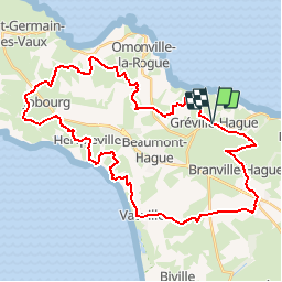
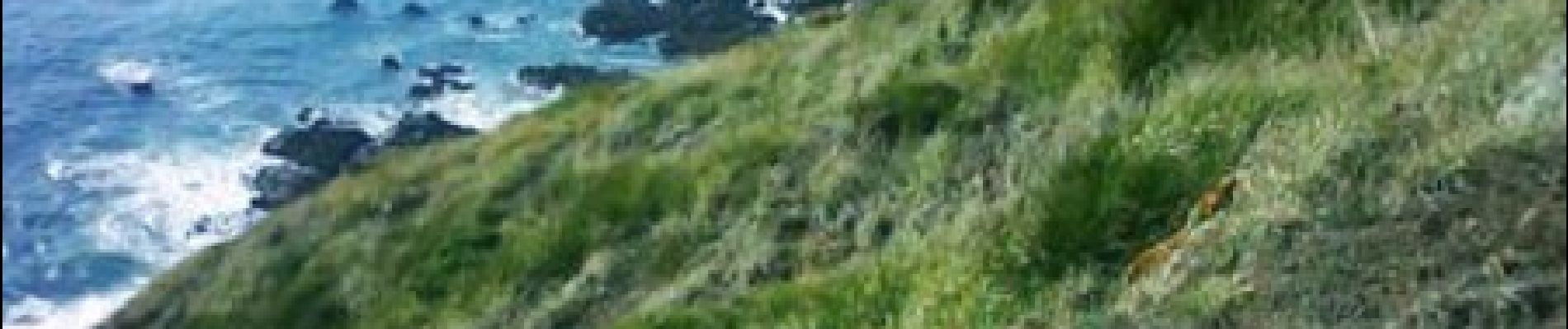
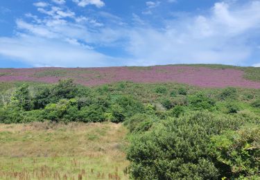
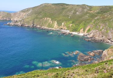
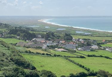
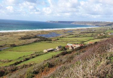
Dans ce petit pays, la côte prend toutes les formes que la nature a imaginées : dunes, falaises, plages de sable fin et de galets, côtes rocheuses tapissées de landes, bruyère et ajoncs, laissent place à l'intérieur du bocage aux vallées paisibles, petits bois et ruisseaux. Depuis toujours l'Homme habite la Hague, discrets hameaux ou riches manoirs, vieilles pierres et écrins de verdure composent ce patrimoine remarquablement préservé. Le tour du canton de Beaumont passe par 8 des 19 communes de la Hague. A la découverte du bocage Haguais et de ses magnifiques paysages tels que les falaises d’Herquemoulin, les pierres Pouquelées de Vauville ou encore les villages de Gréville Hague et Digulleville.
Localisation
Commentaires
Randonnées à proximité
![Randonnée Vélo La Hague - La Haguarde Bitumeuse 2011 - Gréville Hague - Photo](https://media.geolcdn.com/t/375/260/ext.jpg?maxdim=2&url=https%3A%2F%2Fservices.sitytrail.com%2FGeolivesWS%2FDownloadMedia.ashx%3FTrailID%3D106083%26Media%3D10276_1.jpg)
![Vélo Vélo](https://static1.geolcdn.com/sitytour/trail-icons/200.png)
Vélo
![](/images/other/stat-length.png)
![](https://static1.geolcdn.com/siteimages/upload/files/16400158638029165_repeat_loop_refresh_sync_direction_icon.png)
![Randonnée A pied La Hague - Séjour Cotentin Etape 1 Hurville Nacqueville à Jobourg - Photo](https://media.geolcdn.com/t/375/260/325b52e2-ddc9-413a-80e9-916b8f145511.jpg&format=jpg&maxdim=2)
![A pied A pied](https://static1.geolcdn.com/sitytour/trail-icons/100.png)
A pied
![](/images/other/stat-length.png)
![](https://static1.geolcdn.com/siteimages/upload/files/16400158638029165_repeat_loop_refresh_sync_direction_icon.png)
![Randonnée Marche La Hague - landemer / goury - Photo](https://media.geolcdn.com/t/375/260/ext.jpg?maxdim=2&url=https%3A%2F%2Fstatic1.geolcdn.com%2Fsiteimages%2Fupload%2Ffiles%2F1553511878bg_sport_marche.png)
![Marche Marche](https://static1.geolcdn.com/sitytour/trail-icons/101.png)
Marche
![](/images/other/stat-length.png)
![](https://static1.geolcdn.com/siteimages/upload/files/16400158638029165_repeat_loop_refresh_sync_direction_icon.png)
![Randonnée Marche La Hague - Normandie étape 5 - Photo](https://media.geolcdn.com/t/375/260/ext.jpg?maxdim=2&url=https%3A%2F%2Fstatic1.geolcdn.com%2Fsiteimages%2Fupload%2Ffiles%2F1553511878bg_sport_marche.png)
![Marche Marche](https://static1.geolcdn.com/sitytour/trail-icons/101.png)
Marche
![](/images/other/stat-length.png)
![](https://static1.geolcdn.com/siteimages/upload/files/16400158638029165_repeat_loop_refresh_sync_direction_icon.png)
![Randonnée Marche La Hague - Vauville - Photo](https://media.geolcdn.com/t/375/260/2b220e39-b1b1-4526-a0cf-9eab92539eb2.jpg&format=jpg&maxdim=2)
![Marche Marche](https://static1.geolcdn.com/sitytour/trail-icons/101.png)
![Randonnée Marche La Hague - Autour de la ferme du Tourp - Photo](https://media.geolcdn.com/t/375/260/daff8d4b-c9f0-4a43-af85-079207cb08e2.jpg&format=jpg&maxdim=2)
![Marche Marche](https://static1.geolcdn.com/sitytour/trail-icons/101.png)
Marche
![](/images/other/stat-length.png)
![](https://static1.geolcdn.com/siteimages/upload/files/16400158638029165_repeat_loop_refresh_sync_direction_icon.png)
![Randonnée Marche La Hague - Vauville - Côte Soufflée A/R - Photo](https://media.geolcdn.com/t/375/260/eb27b005-2ab1-4642-aace-d7963dce8dc5.jpg&format=jpg&maxdim=2)
![Marche Marche](https://static1.geolcdn.com/sitytour/trail-icons/101.png)
Marche
![](/images/other/stat-length.png)
![](https://static1.geolcdn.com/siteimages/upload/files/16400158638029165_repeat_loop_refresh_sync_direction_icon.png)
![Randonnée Marche La Hague - Gag - Photo](https://media.geolcdn.com/t/375/260/b3b09df4-3380-48d8-b0c7-2a859452b91a.jpg&format=jpg&maxdim=2)
![Marche Marche](https://static1.geolcdn.com/sitytour/trail-icons/101.png)
![Randonnée Marche La Hague - Vauville, dunes de Biville Héauville - Photo](https://media.geolcdn.com/t/375/260/26dd8ef3-68e9-4a0b-a9e4-59cc22a7a231.jpg&format=jpg&maxdim=2)
![Marche Marche](https://static1.geolcdn.com/sitytour/trail-icons/101.png)
Marche
![](/images/other/stat-length.png)
![](https://static1.geolcdn.com/siteimages/upload/files/16400158638029165_repeat_loop_refresh_sync_direction_icon.png)