![](/images/other/stat-length.png)
![Randonnée Marche Saint-André-de-Seignanx - Autour du Marais d'Orx à Labenne - Photo](https://media.geolcdn.com/t/1900/400/ext.pjpeg?maxdim=2&url=https%3A%2F%2Fservices.sitytrail.com%2FGeolivesWS%2FDownloadMedia.ashx%3FTrailID%3D110313%26Media%3D5741_1.jpg)
Autour du Marais d'Orx à Labenne
tracegps
Utilisateur
![Longueur](/images/other/stat-length.png)
Longueur
5,5 km
![Altitude max](https://static1.geolcdn.com/siteimages/upload/files/1508320355ic_sort_altitude_max_24dp.png)
Altitude max
6 m
![Dénivelé positif](https://static1.geolcdn.com/siteimages/upload/files/1508320355ic_sort_den_pos_24dp.png)
Dénivelé positif
16 m
![Km-Effort](/images/other/stat-length.png)
Km-Effort
5,7 km
![Altitude min](https://static1.geolcdn.com/siteimages/upload/files/1508320355ic_sort_altitude_min_24dp.png)
Altitude min
-2 m
![Dénivelé négatif](https://static1.geolcdn.com/siteimages/upload/files/1508320355ic_sort_den_neg_24dp.png)
Dénivelé négatif
16 m
![Boucle](https://static1.geolcdn.com/siteimages/upload/files/16400158638029165_repeat_loop_refresh_sync_direction_icon.png)
Boucle
Oui
Date de création :
2014-12-10 00:00:00.0
Dernière modification :
2014-12-10 00:00:00.0
![Marche](https://static1.geolcdn.com/sitytour/trail-icons/101.png)
1h30
Difficulté : Moyen
![Scannez ce code QR pour ouvrir la randonnée dans l'application SityTrail](https://capi.geolives.com/qq0zvz2zws4bq2lad0pu/sitytour/trails/110313/qr.png?size=200)
Application GPS de randonnée GRATUITE
À propos
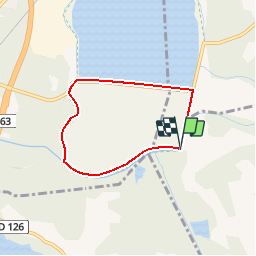
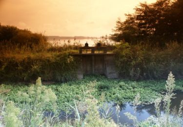
Randonnée Marche de 5,5 km à découvrir à Nouvelle-Aquitaine, Landes, Saint-André-de-Seignanx. Cette randonnée est proposée par tracegps.
Description
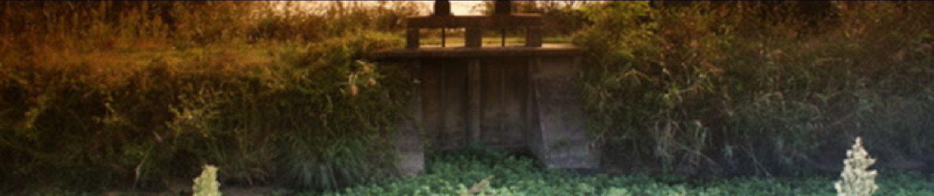
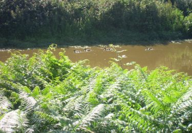
Partez à la découverte d'une vallée humide abritant la réserve naturelle du Marais d'Orx. Vous pourrez y admirer une flore verdoyante ainsi que une faune typique des zones humides landaises comme l'Aigrette Gazette ou le Héron.
Localisation
Pays :
France
Région :
Nouvelle-Aquitaine
Département/Province :
Landes
Commune :
Saint-André-de-Seignanx
Localité :
Unknown
Départ:(Dec)
Départ:(UTM)
630007 ; 4826591 (30T) N.
Commentaires
Randonnées à proximité
![Randonnée V.T.T. Saint-Martin-de-Seignanx - boucle vtt lande - Photo](https://media.geolcdn.com/t/375/260/ext.jpg?maxdim=2&url=https%3A%2F%2Fstatic1.geolcdn.com%2Fsiteimages%2Fupload%2Ffiles%2F1524743154velo.jpg)
![V.T.T. V.T.T.](https://static1.geolcdn.com/sitytour/trail-icons/202.png)
boucle vtt lande
V.T.T.
Facile
(1)
Saint-Martin-de-Seignanx,
Nouvelle-Aquitaine,
Landes,
France
![](/images/other/stat-length.png)
13,1 km | 14,9 km-effort
Inconnu
![](https://static1.geolcdn.com/siteimages/upload/files/16400158638029165_repeat_loop_refresh_sync_direction_icon.png)
Oui
![Randonnée Marche Labenne - Marais d'Orx et alentours - Photo](https://media.geolcdn.com/t/375/260/ext.jpg?maxdim=2&url=https%3A%2F%2Fservices.sitytrail.com%2FGeolivesWS%2FDownloadMedia.ashx%3FTrailID%3D172398%26Media%3D13745_4.jpg)
![Marche Marche](https://static1.geolcdn.com/sitytour/trail-icons/101.png)
Marais d'Orx et alentours
Marche
Moyen
Labenne,
Nouvelle-Aquitaine,
Landes,
France
![](/images/other/stat-length.png)
15,5 km | 17,6 km-effort
3h 30min
![](https://static1.geolcdn.com/siteimages/upload/files/16400158638029165_repeat_loop_refresh_sync_direction_icon.png)
Oui
![Randonnée Marche Saint-Martin-de-Seignanx - St André et St Martin de Seignanx - Photo](https://media.geolcdn.com/t/375/260/ext.jpg?maxdim=2&url=https%3A%2F%2Fservices.sitytrail.com%2FGeolivesWS%2FDownloadMedia.ashx%3FTrailID%3D110312%26Media%3D5740_1.jpg)
![Marche Marche](https://static1.geolcdn.com/sitytour/trail-icons/101.png)
St André et St Martin de Seignanx
Marche
Moyen
Saint-Martin-de-Seignanx,
Nouvelle-Aquitaine,
Landes,
France
![](/images/other/stat-length.png)
14,3 km | 16,5 km-effort
3h 30min
![](https://static1.geolcdn.com/siteimages/upload/files/16400158638029165_repeat_loop_refresh_sync_direction_icon.png)
Oui
![Randonnée V.T.T. Saint-Martin-de-Seignanx - Vallée du canal de Moussehouns et Marais d'Orx - Photo](https://media.geolcdn.com/t/375/260/ext.jpg?maxdim=2&url=https%3A%2F%2Fservices.sitytrail.com%2FGeolivesWS%2FDownloadMedia.ashx%3FTrailID%3D110307%26Media%3D5735_1.jpg)
![V.T.T. V.T.T.](https://static1.geolcdn.com/sitytour/trail-icons/202.png)
Vallée du canal de Moussehouns et Marais d'Orx
V.T.T.
Moyen
(1)
Saint-Martin-de-Seignanx,
Nouvelle-Aquitaine,
Landes,
France
![](/images/other/stat-length.png)
13,1 km | 14,9 km-effort
1h 15min
![](https://static1.geolcdn.com/siteimages/upload/files/16400158638029165_repeat_loop_refresh_sync_direction_icon.png)
Oui
![Randonnée Marche Labenne - marais d orx labenne - Photo](https://media.geolcdn.com/t/375/260/ext.jpg?maxdim=2&url=https%3A%2F%2Fstatic1.geolcdn.com%2Fsiteimages%2Fupload%2Ffiles%2F1553511878bg_sport_marche.png)
![Marche Marche](https://static1.geolcdn.com/sitytour/trail-icons/101.png)
marais d orx labenne
Marche
Difficile
Labenne,
Nouvelle-Aquitaine,
Landes,
France
![](/images/other/stat-length.png)
15,6 km | 17,6 km-effort
4h 0min
![](https://static1.geolcdn.com/siteimages/upload/files/16400158638029165_repeat_loop_refresh_sync_direction_icon.png)
Oui
![Randonnée V.T.T. Labenne - Labenne Barre de Adour - Photo](https://media.geolcdn.com/t/375/260/ext.jpg?maxdim=2&url=https%3A%2F%2Fstatic1.geolcdn.com%2Fsiteimages%2Fupload%2Ffiles%2F1524743154velo.jpg)
![V.T.T. V.T.T.](https://static1.geolcdn.com/sitytour/trail-icons/202.png)
Labenne Barre de Adour
V.T.T.
Facile
Labenne,
Nouvelle-Aquitaine,
Landes,
France
![](/images/other/stat-length.png)
37 km | 41 km-effort
1h 58min
![](https://static1.geolcdn.com/siteimages/upload/files/16400158638029165_repeat_loop_refresh_sync_direction_icon.png)
Non
![Randonnée Marche Labenne - Balade 1 - Photo](https://media.geolcdn.com/t/375/260/ext.jpg?maxdim=2&url=https%3A%2F%2Fstatic1.geolcdn.com%2Fsiteimages%2Fupload%2Ffiles%2F1553511878bg_sport_marche.png)
![Marche Marche](https://static1.geolcdn.com/sitytour/trail-icons/101.png)
![Randonnée Marche Labenne - Tour du Marais d'Orx - Photo](https://media.geolcdn.com/t/375/260/ext.jpg?maxdim=2&url=https%3A%2F%2Fstatic1.geolcdn.com%2Fsiteimages%2Fupload%2Ffiles%2F1553511878bg_sport_marche.png)
![Marche Marche](https://static1.geolcdn.com/sitytour/trail-icons/101.png)
Tour du Marais d'Orx
Marche
Très facile
Labenne,
Nouvelle-Aquitaine,
Landes,
France
![](/images/other/stat-length.png)
6,9 km | 7,2 km-effort
1h 39min
![](https://static1.geolcdn.com/siteimages/upload/files/16400158638029165_repeat_loop_refresh_sync_direction_icon.png)
Oui
![Randonnée Marche Capbreton - 039 Capbreton Bayonne - Photo](https://media.geolcdn.com/t/375/260/ext.jpg?maxdim=2&url=https%3A%2F%2Fstatic1.geolcdn.com%2Fsiteimages%2Fupload%2Ffiles%2F1553511878bg_sport_marche.png)
![Marche Marche](https://static1.geolcdn.com/sitytour/trail-icons/101.png)
039 Capbreton Bayonne
Marche
Très facile
Capbreton,
Nouvelle-Aquitaine,
Landes,
France
![](/images/other/stat-length.png)
27 km | 30 km-effort
6h 35min
![](https://static1.geolcdn.com/siteimages/upload/files/16400158638029165_repeat_loop_refresh_sync_direction_icon.png)
Non