![](/images/other/stat-length.png)
![Randonnée V.T.T. Dabo - Circuit VTT du Chat Noir - Photo](https://media.geolcdn.com/t/1900/400/ext.pjpeg?maxdim=2&url=https%3A%2F%2Fservices.sitytrail.com%2FGeolivesWS%2FDownloadMedia.ashx%3FTrailID%3D110255%26Media%3D5592_1.jpg)
Circuit VTT du Chat Noir
tracegps
Utilisateur
![Longueur](/images/other/stat-length.png)
![Altitude max](https://static1.geolcdn.com/siteimages/upload/files/1508320355ic_sort_altitude_max_24dp.png)
![Dénivelé positif](https://static1.geolcdn.com/siteimages/upload/files/1508320355ic_sort_den_pos_24dp.png)
![Km-Effort](/images/other/stat-length.png)
![Altitude min](https://static1.geolcdn.com/siteimages/upload/files/1508320355ic_sort_altitude_min_24dp.png)
![Dénivelé négatif](https://static1.geolcdn.com/siteimages/upload/files/1508320355ic_sort_den_neg_24dp.png)
![Boucle](https://static1.geolcdn.com/siteimages/upload/files/16400158638029165_repeat_loop_refresh_sync_direction_icon.png)
![V.T.T.](https://static1.geolcdn.com/sitytour/trail-icons/202.png)
1h30
Difficulté : Difficile
![Scannez ce code QR pour ouvrir la randonnée dans l'application SityTrail](https://capi.geolives.com/qq0zvz2zws4bq2lad0pu/sitytour/trails/110255/qr.png?size=200)
Application GPS de randonnée GRATUITE
À propos
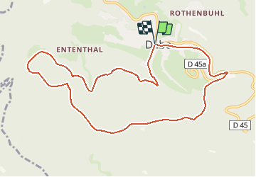
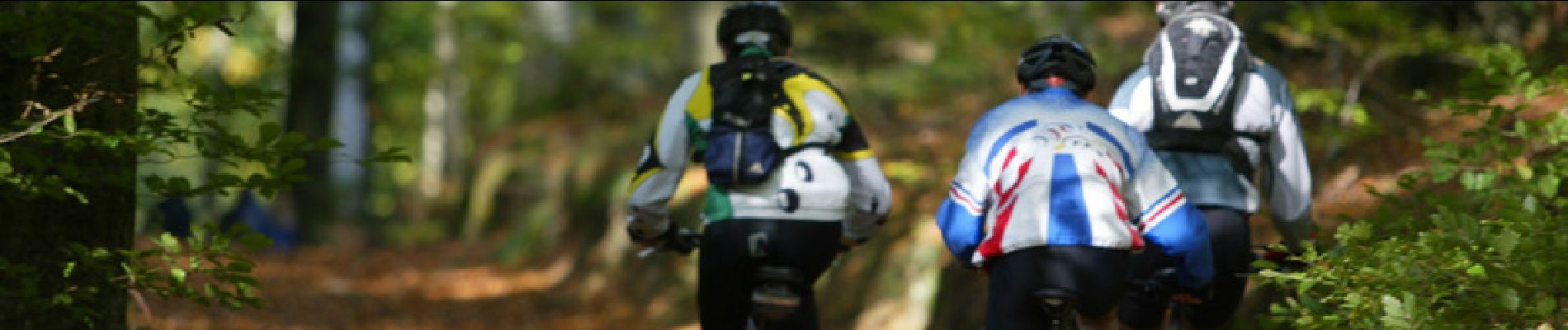
Randonnée V.T.T. de 10,5 km à découvrir à Grand Est, Moselle, Dabo. Cette randonnée est proposée par tracegps.
Description
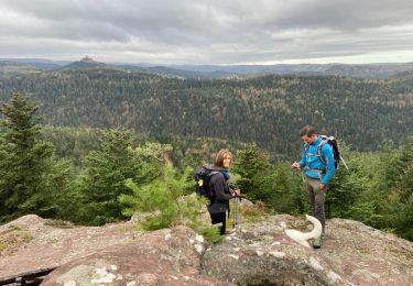
Le circuit part de la Place de l’Eglise et emprunte la rue des Saints avant de rejoindre un sentier très agréable en direction de la Maison Forestière du Jaegerhof. Le sentier débouche sur la clairière de la Maison Forestière, lieu de rencontre des chefs d’Etat Kohl et Mitterand en 1983. Le circuit se poursuit en contournant le Hochkopf culminant à 503 m puis quitte le circuit n°1 en tournant sur la droite et emprunte un sentier en direction de la Croix du Loup. Après une montée d’environ 2 km, on découvre un magnifique point de vue sur le Rocher de Dabo par son côté le moins connu. Le circuit passe ensuite à côté du camping avant de redescendre vers le village.
Localisation
Commentaires
Randonnées à proximité
![Randonnée Marche Reinhardsmunster - 2020-06-13 Marche Ditschelkopf Schweizerberg - Photo](https://media.geolcdn.com/t/375/260/d6670ae9-2bf3-459d-a4b8-1c117627d287.jpg&format=jpg&maxdim=2)
![Marche Marche](https://static1.geolcdn.com/sitytour/trail-icons/101.png)
Marche
![](/images/other/stat-length.png)
![](https://static1.geolcdn.com/siteimages/upload/files/16400158638029165_repeat_loop_refresh_sync_direction_icon.png)
![Randonnée Marche Wangenbourg-Engenthal - 2020-03-14 Marche Engenthal le bas - Photo](https://media.geolcdn.com/t/375/260/ba70735c-7023-4458-a456-f43a6f2e7606.jpg&format=jpg&maxdim=2)
![Marche Marche](https://static1.geolcdn.com/sitytour/trail-icons/101.png)
Marche
![](/images/other/stat-length.png)
![](https://static1.geolcdn.com/siteimages/upload/files/16400158638029165_repeat_loop_refresh_sync_direction_icon.png)
![Randonnée Marche Wangenbourg-Engenthal - 2017-02-24 Marche Schneeberg - Photo](https://media.geolcdn.com/t/375/260/ext.jpg?maxdim=2&url=https%3A%2F%2Fstatic1.geolcdn.com%2Fsiteimages%2Fupload%2Ffiles%2F1553511878bg_sport_marche.png)
![Marche Marche](https://static1.geolcdn.com/sitytour/trail-icons/101.png)
Marche
![](/images/other/stat-length.png)
![](https://static1.geolcdn.com/siteimages/upload/files/16400158638029165_repeat_loop_refresh_sync_direction_icon.png)
![Randonnée Marche Haselbourg - De Haselbourg au Rocher de Falkenfels - Photo](https://media.geolcdn.com/t/375/260/ext.jpg?maxdim=2&url=https%3A%2F%2Fservices.sitytrail.com%2FGeolivesWS%2FDownloadMedia.ashx%3FTrailID%3D348689%26Media%3Da014c99e-bd4e-468a-9561-eeb2cbdf0f57.JPG)
![Marche Marche](https://static1.geolcdn.com/sitytour/trail-icons/101.png)
Marche
![](/images/other/stat-length.png)
![](https://static1.geolcdn.com/siteimages/upload/files/16400158638029165_repeat_loop_refresh_sync_direction_icon.png)
![Randonnée V.T.T. Dabo - Balcon de Dabo 2010 - Photo](https://media.geolcdn.com/t/375/260/ext.jpg?maxdim=2&url=https%3A%2F%2Fstatic1.geolcdn.com%2Fsiteimages%2Fupload%2Ffiles%2F1524743154velo.jpg)
![V.T.T. V.T.T.](https://static1.geolcdn.com/sitytour/trail-icons/202.png)
V.T.T.
![](/images/other/stat-length.png)
![](https://static1.geolcdn.com/siteimages/upload/files/16400158638029165_repeat_loop_refresh_sync_direction_icon.png)
![Randonnée Marche Wangenbourg-Engenthal - obersteigen - Photo](https://media.geolcdn.com/t/375/260/1627429b-7fff-427f-af0e-c37d2da3b0ec.jpg&format=jpg&maxdim=2)
![Marche Marche](https://static1.geolcdn.com/sitytour/trail-icons/101.png)
Marche
![](/images/other/stat-length.png)
![](https://static1.geolcdn.com/siteimages/upload/files/16400158638029165_repeat_loop_refresh_sync_direction_icon.png)
![Randonnée Randonnée équestre Dabo - Tour de dabo Tivio Joyeux - Photo](https://media.geolcdn.com/t/375/260/76dac64e-0da6-4de1-a424-f40eae7e5699.jpg&format=jpg&maxdim=2)
![Randonnée équestre Randonnée équestre](https://static1.geolcdn.com/sitytour/trail-icons/301.png)
Randonnée équestre
![](/images/other/stat-length.png)
![](https://static1.geolcdn.com/siteimages/upload/files/16400158638029165_repeat_loop_refresh_sync_direction_icon.png)
![Randonnée Marche Dabo - 2022-11-01 Marche Dabo et ses Rochers - Photo](https://media.geolcdn.com/t/375/260/63c4e37b-f9cd-403d-a535-8b98d78038cb.jpg&format=jpg&maxdim=2)
![Marche Marche](https://static1.geolcdn.com/sitytour/trail-icons/101.png)
Marche
![](/images/other/stat-length.png)
![](https://static1.geolcdn.com/siteimages/upload/files/16400158638029165_repeat_loop_refresh_sync_direction_icon.png)
![Randonnée Marche Reinhardsmunster - Schuetzenfelsen - Photo](https://media.geolcdn.com/t/375/260/04510d63-cfd1-486f-ab25-499ccfd06d58.jpg&format=jpg&maxdim=2)
![Marche Marche](https://static1.geolcdn.com/sitytour/trail-icons/101.png)
Marche
![](/images/other/stat-length.png)
![](https://static1.geolcdn.com/siteimages/upload/files/16400158638029165_repeat_loop_refresh_sync_direction_icon.png)