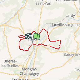
![](/images/other/stat-length.png)
![Randonnée Marche Étréchy - Autour d'Étréchy par le Trou du Sarrazin - Photo](https://media.geolcdn.com/t/1900/400/ext.pjpeg?maxdim=2&url=https%3A%2F%2Fservices.sitytrail.com%2FGeolivesWS%2FDownloadMedia.ashx%3FTrailID%3D110130%26Media%3D5328_1.jpg)
Autour d'Étréchy par le Trou du Sarrazin
tracegps
Utilisateur
![Longueur](/images/other/stat-length.png)
![Altitude max](https://static1.geolcdn.com/siteimages/upload/files/1508320355ic_sort_altitude_max_24dp.png)
![Dénivelé positif](https://static1.geolcdn.com/siteimages/upload/files/1508320355ic_sort_den_pos_24dp.png)
![Km-Effort](/images/other/stat-length.png)
![Altitude min](https://static1.geolcdn.com/siteimages/upload/files/1508320355ic_sort_altitude_min_24dp.png)
![Dénivelé négatif](https://static1.geolcdn.com/siteimages/upload/files/1508320355ic_sort_den_neg_24dp.png)
![Boucle](https://static1.geolcdn.com/siteimages/upload/files/16400158638029165_repeat_loop_refresh_sync_direction_icon.png)
![Marche](https://static1.geolcdn.com/sitytour/trail-icons/101.png)
5h00
Difficulté : Difficile
![Scannez ce code QR pour ouvrir la randonnée dans l'application SityTrail](https://capi.geolives.com/qq0zvz2zws4bq2lad0pu/sitytour/trails/110130/qr.png?size=200)
Application GPS de randonnée GRATUITE
À propos
Randonnée Marche de 25 km à découvrir à Île-de-France, Essonne, Étréchy. Cette randonnée est proposée par tracegps.
Description
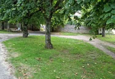
Circuit proposé par le Comité Départemental de Randonnée des Hauts de Seine. Parking de départ : Etrechy gare. Descriptif : nb, Etrechy, le Château-Morin, Chagrenon, Guette-Lièvre ... PR, Auvers Saint-Georges, la Grange-des-Bois, Roche-Ronde ... GR11, la Hai- aux-Prêtres ... PR, Saint-Fiacre ...nb, Challoup ... GR11, Etrèchy, Butte Saint-Martin (14 km), le Coudray ... PR, Vaucelas, Butte-Boigneuse, la Ccroix-Boisée, Cocatrix, Gare Etrechy Des sentiers ont pu être modifiés depuis la dernière validation et les itinéraires proposés n’engagent pas la responsabilité du Comité. Signalez-nous les modifications rencontrées pour mise à jour de la randothèque.
Localisation
Commentaires
Randonnées à proximité
![Randonnée Marche Lardy - Lardy - Chamarande -F - Photo](https://media.geolcdn.com/t/375/260/ext.jpg?maxdim=2&url=https%3A%2F%2Fservices.sitytrail.com%2FGeolivesWS%2FDownloadMedia.ashx%3FTrailID%3D274259%26Media%3Dfix__20140504142726.jpg)
![Marche Marche](https://static1.geolcdn.com/sitytour/trail-icons/101.png)
Marche
![](/images/other/stat-length.png)
![](https://static1.geolcdn.com/siteimages/upload/files/16400158638029165_repeat_loop_refresh_sync_direction_icon.png)
![Randonnée Marche Lardy - Autour de Lardy par la Pierre levée de Janville sur Juine - Photo](https://media.geolcdn.com/t/375/260/ext.jpg?maxdim=2&url=https%3A%2F%2Fservices.sitytrail.com%2FGeolivesWS%2FDownloadMedia.ashx%3FTrailID%3D110136%26Media%3D5334_1.jpg)
![Marche Marche](https://static1.geolcdn.com/sitytour/trail-icons/101.png)
Marche
![](/images/other/stat-length.png)
![](https://static1.geolcdn.com/siteimages/upload/files/16400158638029165_repeat_loop_refresh_sync_direction_icon.png)
![Randonnée A pied Étréchy - Linéaire Etrechy - Dourdan - Photo](https://media.geolcdn.com/t/375/260/6933a6b2-3858-4fb1-ab0c-7f731489899d.jpg&format=jpg&maxdim=2)
![A pied A pied](https://static1.geolcdn.com/sitytour/trail-icons/100.png)
A pied
![](/images/other/stat-length.png)
![](https://static1.geolcdn.com/siteimages/upload/files/16400158638029165_repeat_loop_refresh_sync_direction_icon.png)
![Randonnée Marche Chamarande - bois de belvedere au depart de chamarande - Photo](https://media.geolcdn.com/t/375/260/ext.jpg?maxdim=2&url=https%3A%2F%2Fstatic1.geolcdn.com%2Fsiteimages%2Fupload%2Ffiles%2F1553511878bg_sport_marche.png)
![Marche Marche](https://static1.geolcdn.com/sitytour/trail-icons/101.png)
Marche
![](/images/other/stat-length.png)
![](https://static1.geolcdn.com/siteimages/upload/files/16400158638029165_repeat_loop_refresh_sync_direction_icon.png)
![Randonnée A pied Auvers-Saint-Georges - Au grès de la Juine - Photo](https://media.geolcdn.com/t/375/260/72c017b2-4cbc-4eae-9d9f-90478ed2d91b.jpeg&format=jpg&maxdim=2)
![A pied A pied](https://static1.geolcdn.com/sitytour/trail-icons/100.png)
A pied
![](/images/other/stat-length.png)
![](https://static1.geolcdn.com/siteimages/upload/files/16400158638029165_repeat_loop_refresh_sync_direction_icon.png)
![Randonnée Marche Étréchy - Boucle de 2 jours au départ d'Etréchy via Etampes Chalo St Mars - Photo](https://media.geolcdn.com/t/375/260/ext.jpg?maxdim=2&url=https%3A%2F%2Fstatic1.geolcdn.com%2Fsiteimages%2Fupload%2Ffiles%2F1553511878bg_sport_marche.png)
![Marche Marche](https://static1.geolcdn.com/sitytour/trail-icons/101.png)
Marche
![](/images/other/stat-length.png)
![](https://static1.geolcdn.com/siteimages/upload/files/16400158638029165_repeat_loop_refresh_sync_direction_icon.png)
![Randonnée Marche Brières-les-Scellés - Brières-les-Scellés - Bois de la Garenne - Photo](https://media.geolcdn.com/t/375/260/146d9937-c530-4346-9ec8-f0fc9080ab1e.jpg&format=jpg&maxdim=2)
![Marche Marche](https://static1.geolcdn.com/sitytour/trail-icons/101.png)
Marche
![](/images/other/stat-length.png)
![](https://static1.geolcdn.com/siteimages/upload/files/16400158638029165_repeat_loop_refresh_sync_direction_icon.png)
![Randonnée Marche Villeconin - Villeconin - Photo](https://media.geolcdn.com/t/375/260/4c2738cd-d8e9-4cad-ac5e-3768674ab35a.jpg&format=jpg&maxdim=2)
![Marche Marche](https://static1.geolcdn.com/sitytour/trail-icons/101.png)
Marche
![](/images/other/stat-length.png)
![](https://static1.geolcdn.com/siteimages/upload/files/16400158638029165_repeat_loop_refresh_sync_direction_icon.png)
![Randonnée Marche Auvers-Saint-Georges - Auvers-Saint-Georges - Photo](https://media.geolcdn.com/t/375/260/94651cc4-eb6a-4aac-ab8a-ddf377c2df63.jpg&format=jpg&maxdim=2)
![Marche Marche](https://static1.geolcdn.com/sitytour/trail-icons/101.png)
Marche
![](/images/other/stat-length.png)
![](https://static1.geolcdn.com/siteimages/upload/files/16400158638029165_repeat_loop_refresh_sync_direction_icon.png)