![](/images/other/stat-length.png)
![Randonnée Vélo Bray-sur-Somme - Les Anguillères - Bray sur Somme - Photo](https://media.geolcdn.com/t/1900/400/ext.pjpeg?maxdim=2&url=https%3A%2F%2Fservices.sitytrail.com%2FGeolivesWS%2FDownloadMedia.ashx%3FTrailID%3D109978%26Media%3D5060_1.jpg)
Les Anguillères - Bray sur Somme
tracegps
Utilisateur
![Longueur](/images/other/stat-length.png)
![Altitude max](https://static1.geolcdn.com/siteimages/upload/files/1508320355ic_sort_altitude_max_24dp.png)
![Dénivelé positif](https://static1.geolcdn.com/siteimages/upload/files/1508320355ic_sort_den_pos_24dp.png)
![Km-Effort](/images/other/stat-length.png)
![Altitude min](https://static1.geolcdn.com/siteimages/upload/files/1508320355ic_sort_altitude_min_24dp.png)
![Dénivelé négatif](https://static1.geolcdn.com/siteimages/upload/files/1508320355ic_sort_den_neg_24dp.png)
![Boucle](https://static1.geolcdn.com/siteimages/upload/files/16400158638029165_repeat_loop_refresh_sync_direction_icon.png)
![Vélo](https://static1.geolcdn.com/sitytour/trail-icons/200.png)
3h00
Difficulté : Moyen
![Scannez ce code QR pour ouvrir la randonnée dans l'application SityTrail](https://capi.geolives.com/qq0zvz2zws4bq2lad0pu/sitytour/trails/109978/qr.png?size=200)
Application GPS de randonnée GRATUITE
À propos
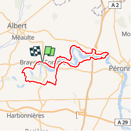
Randonnée Vélo de 51 km à découvrir à Hauts-de-France, Somme, Bray-sur-Somme. Cette randonnée est proposée par tracegps.
Description
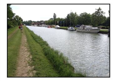
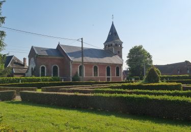
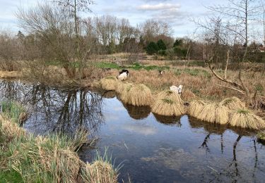
Les Anguillères - Bray sur Somme Départ : place de Bray-sur-Somme. Un circuit pour découvrir la vallée de la Haute Somme où la pêche à l’anguille était très développée à une certaine époque. Vous pourrez encore apercevoir quelques anguillères : sorte de « pièges » permettant de capturer les anguilles pendant leur migration. À voir : Froissy : le p’tit train de la Haute Somme Bray-sur-Somme : musée d’histoire locale, église Saint-Nicolas Vaux : belvédère : point de vue sur les étangs de la Somme. Cappy : église classée Monument Historique, base nautique et halte fluviale.
Localisation
Commentaires
Randonnées à proximité
![Randonnée Marche Cappy - Les Marais de Suzanne - Cappy - Photo](https://media.geolcdn.com/t/375/260/ext.jpg?maxdim=2&url=https%3A%2F%2Fservices.sitytrail.com%2FGeolivesWS%2FDownloadMedia.ashx%3FTrailID%3D318046%26Media%3D17516_6.jpg)
![Marche Marche](https://static1.geolcdn.com/sitytour/trail-icons/101.png)
Marche
![](/images/other/stat-length.png)
![](https://static1.geolcdn.com/siteimages/upload/files/16400158638029165_repeat_loop_refresh_sync_direction_icon.png)
![Randonnée Marche Étinehem-Méricourt - Les marais des vaches - Photo](https://media.geolcdn.com/t/375/260/ext.jpg?maxdim=2&url=https%3A%2F%2Fstatic1.geolcdn.com%2Fsiteimages%2Fupload%2Ffiles%2F1553511878bg_sport_marche.png)
![Marche Marche](https://static1.geolcdn.com/sitytour/trail-icons/101.png)
Marche
![](/images/other/stat-length.png)
![](https://static1.geolcdn.com/siteimages/upload/files/16400158638029165_repeat_loop_refresh_sync_direction_icon.png)
![Randonnée Marche Étinehem-Méricourt - les Marais des Vaches - Photo](https://media.geolcdn.com/t/375/260/2665f6d2-4a5d-4afb-8d23-a25653468188.jpg&format=jpg&maxdim=2)
![Marche Marche](https://static1.geolcdn.com/sitytour/trail-icons/101.png)
Marche
![](/images/other/stat-length.png)
![](https://static1.geolcdn.com/siteimages/upload/files/16400158638029165_repeat_loop_refresh_sync_direction_icon.png)
![Randonnée A pied Étinehem-Méricourt - Les Marais de la Violette - Photo](https://media.geolcdn.com/t/375/260/99ec3131-5341-448c-a854-8a5aa8fa62eb.jpeg&format=jpg&maxdim=2)
![A pied A pied](https://static1.geolcdn.com/sitytour/trail-icons/100.png)
A pied
![](/images/other/stat-length.png)
![](https://static1.geolcdn.com/siteimages/upload/files/16400158638029165_repeat_loop_refresh_sync_direction_icon.png)
![Randonnée A pied Cappy - Les Royards - Photo](https://media.geolcdn.com/t/375/260/61c5a7bb-5adb-45c2-89f4-300458b09b65.jpeg&format=jpg&maxdim=2)
![A pied A pied](https://static1.geolcdn.com/sitytour/trail-icons/100.png)
A pied
![](/images/other/stat-length.png)
![](https://static1.geolcdn.com/siteimages/upload/files/16400158638029165_repeat_loop_refresh_sync_direction_icon.png)
![Randonnée Marche Étinehem-Méricourt - le marais des vaches - Photo](https://media.geolcdn.com/t/375/260/240abb99-bbb2-41a8-ac2f-0c05093fc1f4.jpg&format=jpg&maxdim=2)
![Marche Marche](https://static1.geolcdn.com/sitytour/trail-icons/101.png)
Marche
![](/images/other/stat-length.png)
![](https://static1.geolcdn.com/siteimages/upload/files/16400158638029165_repeat_loop_refresh_sync_direction_icon.png)
![Randonnée Marche Cappy - Les Champs Muraine - Cappy - Photo](https://media.geolcdn.com/t/375/260/ext.jpg?maxdim=2&url=https%3A%2F%2Fservices.sitytrail.com%2FGeolivesWS%2FDownloadMedia.ashx%3FTrailID%3D316902%26Media%3D15996_1.jpg)
![Marche Marche](https://static1.geolcdn.com/sitytour/trail-icons/101.png)
Marche
![](/images/other/stat-length.png)
![](https://static1.geolcdn.com/siteimages/upload/files/16400158638029165_repeat_loop_refresh_sync_direction_icon.png)
![Randonnée Marche Chuignolles - CHUIGNOLLES - 80 Circuit du gros canon - Photo](https://media.geolcdn.com/t/375/260/9b9d871f-5b11-44ae-ade1-6d8bca7d07de.jpg&format=jpg&maxdim=2)
![Marche Marche](https://static1.geolcdn.com/sitytour/trail-icons/101.png)
Marche
![](/images/other/stat-length.png)
![](https://static1.geolcdn.com/siteimages/upload/files/16400158638029165_repeat_loop_refresh_sync_direction_icon.png)
![Randonnée Marche Bray-sur-Somme - Bray sur Somme - Photo](https://media.geolcdn.com/t/375/260/72bf1ca5-f920-4b62-805b-e698fd965403.jpg&format=jpg&maxdim=2)
![Marche Marche](https://static1.geolcdn.com/sitytour/trail-icons/101.png)
Marche
![](/images/other/stat-length.png)
![](https://static1.geolcdn.com/siteimages/upload/files/16400158638029165_repeat_loop_refresh_sync_direction_icon.png)