![](/images/other/stat-length.png)
![Randonnée Vélo Ailly-sur-Noye - Le Val de Noye - Boucle de Coullemelle - Photo](https://media.geolcdn.com/t/1900/400/ext.pjpeg?maxdim=2&url=https%3A%2F%2Fservices.sitytrail.com%2FGeolivesWS%2FDownloadMedia.ashx%3FTrailID%3D109971%26Media%3D5052_1.jpg)
Le Val de Noye - Boucle de Coullemelle
tracegps
Utilisateur
![Longueur](/images/other/stat-length.png)
Longueur
33 km
![Altitude max](https://static1.geolcdn.com/siteimages/upload/files/1508320355ic_sort_altitude_max_24dp.png)
Altitude max
156 m
![Dénivelé positif](https://static1.geolcdn.com/siteimages/upload/files/1508320355ic_sort_den_pos_24dp.png)
Dénivelé positif
352 m
![Km-Effort](/images/other/stat-length.png)
Km-Effort
38 km
![Altitude min](https://static1.geolcdn.com/siteimages/upload/files/1508320355ic_sort_altitude_min_24dp.png)
Altitude min
48 m
![Dénivelé négatif](https://static1.geolcdn.com/siteimages/upload/files/1508320355ic_sort_den_neg_24dp.png)
Dénivelé négatif
350 m
![Boucle](https://static1.geolcdn.com/siteimages/upload/files/16400158638029165_repeat_loop_refresh_sync_direction_icon.png)
Boucle
Oui
Date de création :
2014-12-10 00:00:00.0
Dernière modification :
2014-12-10 00:00:00.0
![Vélo](https://static1.geolcdn.com/sitytour/trail-icons/200.png)
2h00
Difficulté : Moyen
![Scannez ce code QR pour ouvrir la randonnée dans l'application SityTrail](https://capi.geolives.com/qq0zvz2zws4bq2lad0pu/sitytour/trails/109971/qr.png?size=200)
Application GPS de randonnée GRATUITE
À propos
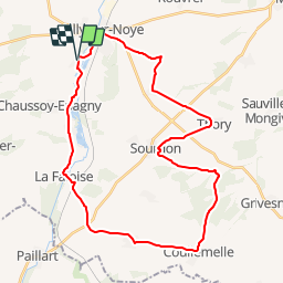
Randonnée Vélo de 33 km à découvrir à Hauts-de-France, Somme, Ailly-sur-Noye. Cette randonnée est proposée par tracegps.
Description
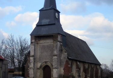
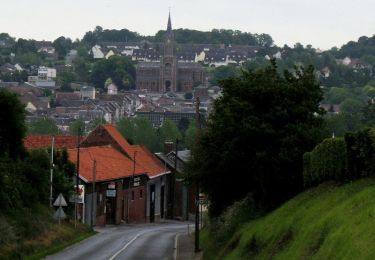
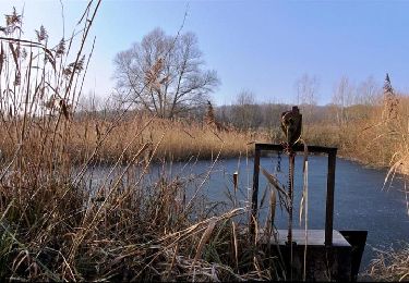
Le Val de Noye - Boucle de Coullemelle Une boucle à la découverte d’une très jolie vallée enchâssée dans un écrin de verdure avec étangs et peupleraies. À voir ; Vallée de la Noye : nombreux étangs.
Localisation
Pays :
France
Région :
Hauts-de-France
Département/Province :
Somme
Commune :
Ailly-sur-Noye
Localité :
Unknown
Départ:(Dec)
Départ:(UTM)
453118 ; 5510511 (31U) N.
Commentaires
Randonnées à proximité
![Randonnée Marche Remiencourt - Le bois du Roi - Photo](https://media.geolcdn.com/t/375/260/ext.jpg?maxdim=2&url=https%3A%2F%2Fservices.sitytrail.com%2FGeolivesWS%2FDownloadMedia.ashx%3FTrailID%3D108859%26Media%3D2403_2.jpg)
![Marche Marche](https://static1.geolcdn.com/sitytour/trail-icons/101.png)
Le bois du Roi
Marche
Difficile
(1)
Remiencourt,
Hauts-de-France,
Somme,
France
![](/images/other/stat-length.png)
12,4 km | 15,2 km-effort
4h 0min
![](https://static1.geolcdn.com/siteimages/upload/files/16400158638029165_repeat_loop_refresh_sync_direction_icon.png)
Oui
![Randonnée Marche Remiencourt - le bois du roi Remiencourt 80 - Photo](https://media.geolcdn.com/t/375/260/bc50bb6a-30a4-4e52-8497-2c709f5b6312.jpg&format=jpg&maxdim=2)
![Marche Marche](https://static1.geolcdn.com/sitytour/trail-icons/101.png)
le bois du roi Remiencourt 80
Marche
Moyen
Remiencourt,
Hauts-de-France,
Somme,
France
![](/images/other/stat-length.png)
12,7 km | 15,4 km-effort
3h 10min
![](https://static1.geolcdn.com/siteimages/upload/files/16400158638029165_repeat_loop_refresh_sync_direction_icon.png)
Oui
![Randonnée Marche Ailly-sur-Noye - Bois de Berny - Photo](https://media.geolcdn.com/t/375/260/ext.jpg?maxdim=2&url=https%3A%2F%2Fstatic1.geolcdn.com%2Fsiteimages%2Fupload%2Ffiles%2F1553511878bg_sport_marche.png)
![Marche Marche](https://static1.geolcdn.com/sitytour/trail-icons/101.png)
Bois de Berny
Marche
Moyen
(1)
Ailly-sur-Noye,
Hauts-de-France,
Somme,
France
![](/images/other/stat-length.png)
10,1 km | 12,1 km-effort
2h 38min
![](https://static1.geolcdn.com/siteimages/upload/files/16400158638029165_repeat_loop_refresh_sync_direction_icon.png)
Oui
![Randonnée Marche Sourdon - Autour d'Ainval - Sourdon - Photo](https://media.geolcdn.com/t/375/260/ext.jpg?maxdim=2&url=https%3A%2F%2Fservices.sitytrail.com%2FGeolivesWS%2FDownloadMedia.ashx%3FTrailID%3D316957%26Media%3D16075_4.jpg)
![Marche Marche](https://static1.geolcdn.com/sitytour/trail-icons/101.png)
Autour d'Ainval - Sourdon
Marche
Moyen
Sourdon,
Hauts-de-France,
Somme,
France
![](/images/other/stat-length.png)
10,4 km | 12,3 km-effort
3h 0min
![](https://static1.geolcdn.com/siteimages/upload/files/16400158638029165_repeat_loop_refresh_sync_direction_icon.png)
Oui
![Randonnée Marche Grattepanche - Grattepanche-Absous-Larris - Photo](https://media.geolcdn.com/t/375/260/ext.jpg?maxdim=2&url=https%3A%2F%2Fstatic1.geolcdn.com%2Fsiteimages%2Fupload%2Ffiles%2F1553511878bg_sport_marche.png)
![Marche Marche](https://static1.geolcdn.com/sitytour/trail-icons/101.png)
Grattepanche-Absous-Larris
Marche
Difficile
(1)
Grattepanche,
Hauts-de-France,
Somme,
France
![](/images/other/stat-length.png)
11 km | 13 km-effort
2h 51min
![](https://static1.geolcdn.com/siteimages/upload/files/16400158638029165_repeat_loop_refresh_sync_direction_icon.png)
Oui
![Randonnée A pied Grattepanche - La Montagne des Grès - Photo](https://media.geolcdn.com/t/375/260/6ef53137-0400-4626-9dd4-c31a6d8d7c2e.jpeg&format=jpg&maxdim=2)
![A pied A pied](https://static1.geolcdn.com/sitytour/trail-icons/100.png)
La Montagne des Grès
A pied
Facile
Grattepanche,
Hauts-de-France,
Somme,
France
![](/images/other/stat-length.png)
3,9 km | 4,8 km-effort
1h 5min
![](https://static1.geolcdn.com/siteimages/upload/files/16400158638029165_repeat_loop_refresh_sync_direction_icon.png)
Non
![Randonnée Autre activité Ailly-sur-Noye - f - Photo](https://media.geolcdn.com/t/375/260/ext.jpg?maxdim=2&url=https%3A%2F%2Fservices.sitytrail.com%2FGeolivesWS%2FDownloadMedia.ashx%3FTrailID%3D227421%26Media%3Dfix__20131016151534.jpg)
![Autre activité Autre activité](https://static1.geolcdn.com/sitytour/trail-icons/900.png)
f
Autre activité
Très facile
Ailly-sur-Noye,
Hauts-de-France,
Somme,
France
![](/images/other/stat-length.png)
18,8 km | 22 km-effort
2h 3min
![](https://static1.geolcdn.com/siteimages/upload/files/16400158638029165_repeat_loop_refresh_sync_direction_icon.png)
Oui
![Randonnée V.T.T. Ailly-sur-Noye - Circuit n° 4 VTT - Ailly-sur-Noye - Photo](https://media.geolcdn.com/t/375/260/ext.jpg?maxdim=2&url=https%3A%2F%2Fservices.sitytrail.com%2FGeolivesWS%2FDownloadMedia.ashx%3FTrailID%3D111125%26Media%3D6480_2.jpg)
![V.T.T. V.T.T.](https://static1.geolcdn.com/sitytour/trail-icons/202.png)
Circuit n° 4 VTT - Ailly-sur-Noye
V.T.T.
Difficile
Ailly-sur-Noye,
Hauts-de-France,
Somme,
France
![](/images/other/stat-length.png)
42 km | 50 km-effort
4h 0min
![](https://static1.geolcdn.com/siteimages/upload/files/16400158638029165_repeat_loop_refresh_sync_direction_icon.png)
Oui
![Randonnée Vélo Ailly-sur-Noye - Le Val de Noye - Boucle de Boves - Photo](https://media.geolcdn.com/t/375/260/ext.jpg?maxdim=2&url=https%3A%2F%2Fservices.sitytrail.com%2FGeolivesWS%2FDownloadMedia.ashx%3FTrailID%3D109972%26Media%3D5053_1.jpg)
![Vélo Vélo](https://static1.geolcdn.com/sitytour/trail-icons/200.png)
Le Val de Noye - Boucle de Boves
Vélo
Moyen
Ailly-sur-Noye,
Hauts-de-France,
Somme,
France
![](/images/other/stat-length.png)
27 km | 30 km-effort
1h 30min
![](https://static1.geolcdn.com/siteimages/upload/files/16400158638029165_repeat_loop_refresh_sync_direction_icon.png)
Oui