![](/images/other/stat-length.png)
![Randonnée Marche Le Hohwald - Du Hohwald au Champ du Feu - Photo](https://media.geolcdn.com/t/1900/400/ext.pjpeg?maxdim=2&url=https%3A%2F%2Fservices.sitytrail.com%2FGeolivesWS%2FDownloadMedia.ashx%3FTrailID%3D109958%26Media%3D5025_1.jpg)
Du Hohwald au Champ du Feu
tracegps
Utilisateur
![Longueur](/images/other/stat-length.png)
Longueur
17,8 km
![Altitude max](https://static1.geolcdn.com/siteimages/upload/files/1508320355ic_sort_altitude_max_24dp.png)
Altitude max
1103 m
![Dénivelé positif](https://static1.geolcdn.com/siteimages/upload/files/1508320355ic_sort_den_pos_24dp.png)
Dénivelé positif
642 m
![Km-Effort](/images/other/stat-length.png)
Km-Effort
26 km
![Altitude min](https://static1.geolcdn.com/siteimages/upload/files/1508320355ic_sort_altitude_min_24dp.png)
Altitude min
567 m
![Dénivelé négatif](https://static1.geolcdn.com/siteimages/upload/files/1508320355ic_sort_den_neg_24dp.png)
Dénivelé négatif
646 m
![Boucle](https://static1.geolcdn.com/siteimages/upload/files/16400158638029165_repeat_loop_refresh_sync_direction_icon.png)
Boucle
Oui
Date de création :
2014-12-10 00:00:00.0
Dernière modification :
2014-12-10 00:00:00.0
![Marche](https://static1.geolcdn.com/sitytour/trail-icons/101.png)
6h00
Difficulté : Très difficile
![Scannez ce code QR pour ouvrir la randonnée dans l'application SityTrail](https://capi.geolives.com/qq0zvz2zws4bq2lad0pu/sitytour/trails/109958/qr.png?size=200)
Application GPS de randonnée GRATUITE
À propos
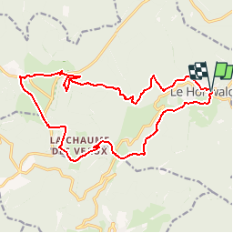
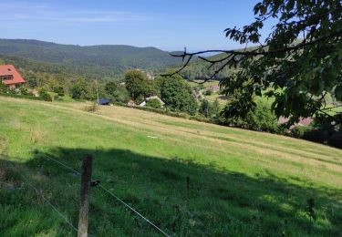
Randonnée Marche de 17,8 km à découvrir à Grand Est, Bas-Rhin, Le Hohwald. Cette randonnée est proposée par tracegps.
Description
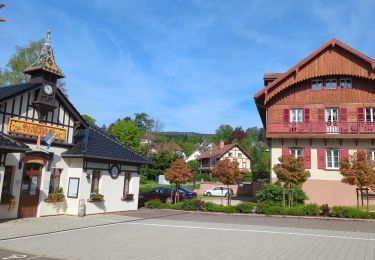
Du Hohwald au Champ du Feu. Des forêts du Hohwald aux chaumes du Champ de Feu en passant par la cascade de l’Andlau. Pour toute information complémentaire sur la randonnée : Comité départemental du Bas Rhin: 9 RUE MEYER 67500 HAGUENAU Tél. : 0388907606
Localisation
Pays :
France
Région :
Grand Est
Département/Province :
Bas-Rhin
Commune :
Le Hohwald
Localité :
Unknown
Départ:(Dec)
Départ:(UTM)
376408 ; 5362511 (32U) N.
Commentaires
Randonnées à proximité
![Randonnée Randonnée équestre Ottrott - 2024-09-03 Journee Rothlach Sommerhof - Photo](https://media.geolcdn.com/t/375/260/83371a81-1c5b-4988-84fb-7fd3471a6a57.jpg&format=jpg&maxdim=2)
![Randonnée équestre Randonnée équestre](https://static1.geolcdn.com/sitytour/trail-icons/301.png)
2024-09-03 Journee Rothlach Sommerhof
Randonnée équestre
Moyen
Ottrott,
Grand Est,
Bas-Rhin,
France
![](/images/other/stat-length.png)
18,8 km | 26 km-effort
3h 23min
![](https://static1.geolcdn.com/siteimages/upload/files/16400158638029165_repeat_loop_refresh_sync_direction_icon.png)
Oui
![Randonnée Marche Le Hohwald - 2024-04-27 Marche Cascade du Hohwald Champ du Feu - Photo](https://media.geolcdn.com/t/375/260/d8b206f8-0969-498e-bcc6-fd799e0e40cd.jpg&format=jpg&maxdim=2)
![Marche Marche](https://static1.geolcdn.com/sitytour/trail-icons/101.png)
2024-04-27 Marche Cascade du Hohwald Champ du Feu
Marche
Moyen
Le Hohwald,
Grand Est,
Bas-Rhin,
France
![](/images/other/stat-length.png)
20 km | 31 km-effort
6h 58min
![](https://static1.geolcdn.com/siteimages/upload/files/16400158638029165_repeat_loop_refresh_sync_direction_icon.png)
Oui
![Randonnée Marche Reichsfeld - 2019-12-28 Marche Reichsfeld Ungersberg Gruckert - Photo](https://media.geolcdn.com/t/375/260/42eae20f-c3f4-4c06-9edb-b597f2c7a1bb.jpg&format=jpg&maxdim=2)
![Marche Marche](https://static1.geolcdn.com/sitytour/trail-icons/101.png)
2019-12-28 Marche Reichsfeld Ungersberg Gruckert
Marche
Très facile
Reichsfeld,
Grand Est,
Bas-Rhin,
France
![](/images/other/stat-length.png)
12,2 km | 20 km-effort
3h 5min
![](https://static1.geolcdn.com/siteimages/upload/files/16400158638029165_repeat_loop_refresh_sync_direction_icon.png)
Oui
![Randonnée Marche Le Hohwald - Tour du Hohwald - Photo](https://media.geolcdn.com/t/375/260/ext.jpg?maxdim=2&url=https%3A%2F%2Fstatic1.geolcdn.com%2Fsiteimages%2Fupload%2Ffiles%2F1553511878bg_sport_marche.png)
![Marche Marche](https://static1.geolcdn.com/sitytour/trail-icons/101.png)
Tour du Hohwald
Marche
Moyen
(1)
Le Hohwald,
Grand Est,
Bas-Rhin,
France
![](/images/other/stat-length.png)
8 km | 11,3 km-effort
2h 26min
![](https://static1.geolcdn.com/siteimages/upload/files/16400158638029165_repeat_loop_refresh_sync_direction_icon.png)
Oui
![Randonnée Marche Ottrott - 2013-12-29 Marche Mt Ste Odile Maennelstein Birkenfels - Photo](https://media.geolcdn.com/t/375/260/ext.jpg?maxdim=2&url=https%3A%2F%2Fstatic1.geolcdn.com%2Fsiteimages%2Fupload%2Ffiles%2F1553511878bg_sport_marche.png)
![Marche Marche](https://static1.geolcdn.com/sitytour/trail-icons/101.png)
2013-12-29 Marche Mt Ste Odile Maennelstein Birkenfels
Marche
Moyen
(1)
Ottrott,
Grand Est,
Bas-Rhin,
France
![](/images/other/stat-length.png)
10,8 km | 15,4 km-effort
3h 24min
![](https://static1.geolcdn.com/siteimages/upload/files/16400158638029165_repeat_loop_refresh_sync_direction_icon.png)
Oui
![Randonnée Marche Le Hohwald - Hohwald - Rothlach - Neuntelstein - Photo](https://media.geolcdn.com/t/375/260/0ea7410a-d32d-4905-9369-a48f058188e6.jpg&format=jpg&maxdim=2)
![Marche Marche](https://static1.geolcdn.com/sitytour/trail-icons/101.png)
Hohwald - Rothlach - Neuntelstein
Marche
Moyen
(1)
Le Hohwald,
Grand Est,
Bas-Rhin,
France
![](/images/other/stat-length.png)
15,8 km | 22 km-effort
4h 28min
![](https://static1.geolcdn.com/siteimages/upload/files/16400158638029165_repeat_loop_refresh_sync_direction_icon.png)
Oui
![Randonnée A pied Le Hohwald - Champ du feu début - Photo](https://media.geolcdn.com/t/375/260/f322735a-2e98-4355-b067-4845daa855de.jpg&format=jpg&maxdim=2)
![A pied A pied](https://static1.geolcdn.com/sitytour/trail-icons/100.png)
Champ du feu début
A pied
Facile
Le Hohwald,
Grand Est,
Bas-Rhin,
France
![](/images/other/stat-length.png)
6,8 km | 9,6 km-effort
2h 10min
![](https://static1.geolcdn.com/siteimages/upload/files/16400158638029165_repeat_loop_refresh_sync_direction_icon.png)
Non
![Randonnée Marche Le Hohwald - le hohwald, boucle](https://media.geolcdn.com/t/375/260/cc43b1d5-9e0d-477b-9cf7-84cc19342b6e.jpg&format=jpg&maxdim=2)
![Marche Marche](https://static1.geolcdn.com/sitytour/trail-icons/101.png)
le hohwald, boucle "petite ceinture"
Marche
Facile
(1)
Le Hohwald,
Grand Est,
Bas-Rhin,
France
![](/images/other/stat-length.png)
3,4 km | 4,8 km-effort
55min
![](https://static1.geolcdn.com/siteimages/upload/files/16400158638029165_repeat_loop_refresh_sync_direction_icon.png)
Oui
![Randonnée Marche Le Hohwald - Hohwald (ter) - Photo](https://media.geolcdn.com/t/375/260/3da381bb-faf8-430b-b807-40072fd051a1.jpg&format=jpg&maxdim=2)
![Marche Marche](https://static1.geolcdn.com/sitytour/trail-icons/101.png)
Hohwald (ter)
Marche
Difficile
Le Hohwald,
Grand Est,
Bas-Rhin,
France
![](/images/other/stat-length.png)
11,2 km | 15,6 km-effort
3h 31min
![](https://static1.geolcdn.com/siteimages/upload/files/16400158638029165_repeat_loop_refresh_sync_direction_icon.png)
Oui
Manque les indications sur le fléchage du club vosgiens. Le parcours total fait 21 km pour 5h de marche, 30 min de casse croûte inclus. Cette randonnée est incontournable