![](/images/other/stat-length.png)
![Randonnée Marche Saint-Christophe-en-Oisans - Tour Gourmand de Saint Christophe en Oisans - Jour 5 - Photo](https://media.geolcdn.com/t/1900/400/ext.pjpeg?maxdim=2&url=https%3A%2F%2Fservices.sitytrail.com%2FGeolivesWS%2FDownloadMedia.ashx%3FTrailID%3D109942%26Media%3D4999_1.jpg)
Tour Gourmand de Saint Christophe en Oisans - Jour 5
tracegps
Utilisateur
![Longueur](/images/other/stat-length.png)
Longueur
8 km
![Altitude max](https://static1.geolcdn.com/siteimages/upload/files/1508320355ic_sort_altitude_max_24dp.png)
Altitude max
2096 m
![Dénivelé positif](https://static1.geolcdn.com/siteimages/upload/files/1508320355ic_sort_den_pos_24dp.png)
Dénivelé positif
548 m
![Km-Effort](/images/other/stat-length.png)
Km-Effort
16,7 km
![Altitude min](https://static1.geolcdn.com/siteimages/upload/files/1508320355ic_sort_altitude_min_24dp.png)
Altitude min
1179 m
![Dénivelé négatif](https://static1.geolcdn.com/siteimages/upload/files/1508320355ic_sort_den_neg_24dp.png)
Dénivelé négatif
947 m
![Boucle](https://static1.geolcdn.com/siteimages/upload/files/16400158638029165_repeat_loop_refresh_sync_direction_icon.png)
Boucle
Non
Date de création :
2014-12-10 00:00:00.0
Dernière modification :
2014-12-10 00:00:00.0
![Marche](https://static1.geolcdn.com/sitytour/trail-icons/101.png)
5h00
Difficulté : Difficile
![Scannez ce code QR pour ouvrir la randonnée dans l'application SityTrail](https://capi.geolives.com/qq0zvz2zws4bq2lad0pu/sitytour/trails/109942/qr.png?size=200)
Application GPS de randonnée GRATUITE
À propos
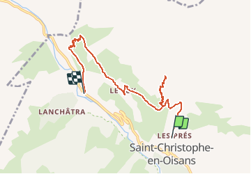
Randonnée Marche de 8 km à découvrir à Auvergne-Rhône-Alpes, Isère, Saint-Christophe-en-Oisans. Cette randonnée est proposée par tracegps.
Description
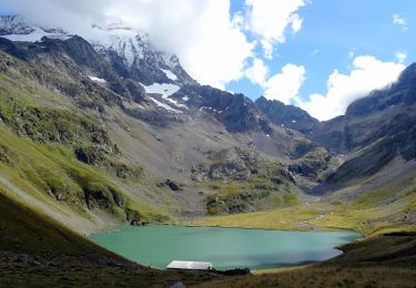
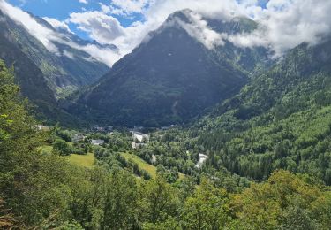
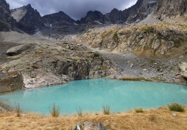
Tour gourmand de Saint Christophe en Oisans – Jour 5 Départ de Saint Christophe pour le Miroir des Fétoules et la Table d'orientation de Peyssa : 5h de marche / 677 m. Redesente sur Plan du Lac.
Localisation
Pays :
France
Région :
Auvergne-Rhône-Alpes
Département/Province :
Isère
Commune :
Saint-Christophe-en-Oisans
Localité :
Unknown
Départ:(Dec)
Départ:(UTM)
277310 ; 4982434 (32T) N.
Commentaires
Randonnées à proximité
![Randonnée Marche Les Deux Alpes - Lac Lauvitel depuis Venosc - Photo](https://media.geolcdn.com/t/375/260/c143dd5b-9bc9-4aa4-a71f-cc60077c341b.jpg&format=jpg&maxdim=2)
![Marche Marche](https://static1.geolcdn.com/sitytour/trail-icons/101.png)
Lac Lauvitel depuis Venosc
Marche
Difficile
Les Deux Alpes,
Auvergne-Rhône-Alpes,
Isère,
France
![](/images/other/stat-length.png)
13,8 km | 24 km-effort
6h 14min
![](https://static1.geolcdn.com/siteimages/upload/files/16400158638029165_repeat_loop_refresh_sync_direction_icon.png)
Oui
![Randonnée Marche Les Deux Alpes - 2020-09-01 Marche Tour de l'Aiguille de Venosc (2 jours) - Photo](https://media.geolcdn.com/t/375/260/34a6bca9-af34-47ba-b9a3-4e85df680f5f.jpg&format=jpg&maxdim=2)
![Marche Marche](https://static1.geolcdn.com/sitytour/trail-icons/101.png)
2020-09-01 Marche Tour de l'Aiguille de Venosc (2 jours)
Marche
Moyen
Les Deux Alpes,
Auvergne-Rhône-Alpes,
Isère,
France
![](/images/other/stat-length.png)
22 km | 47 km-effort
9h 9min
![](https://static1.geolcdn.com/siteimages/upload/files/16400158638029165_repeat_loop_refresh_sync_direction_icon.png)
Oui
![Randonnée Marche Les Deux Alpes - 2020-09-01 Marche Venosc Refuge et lac de la Muzelle - Photo](https://media.geolcdn.com/t/375/260/37e869b2-5bed-4bce-85a1-f553a21d8058.jpg&format=jpg&maxdim=2)
![Marche Marche](https://static1.geolcdn.com/sitytour/trail-icons/101.png)
2020-09-01 Marche Venosc Refuge et lac de la Muzelle
Marche
Moyen
Les Deux Alpes,
Auvergne-Rhône-Alpes,
Isère,
France
![](/images/other/stat-length.png)
8,3 km | 22 km-effort
4h 8min
![](https://static1.geolcdn.com/siteimages/upload/files/16400158638029165_repeat_loop_refresh_sync_direction_icon.png)
Non
![Randonnée Marche Saint-Christophe-en-Oisans - Saint-Christophe-en-Oisans - AR du gîte du Plan du lac au Pont des Granges - 8.4km 240m 4h15 (1h10) - 2015 06 26 - Photo](https://media.geolcdn.com/t/375/260/ext.jpg?maxdim=2&url=https%3A%2F%2Fservices.sitytrail.com%2FGeolivesWS%2FDownloadMedia.ashx%3FTrailID%3D440124%26Media%3Dfix__20150626103336.jpg)
![Marche Marche](https://static1.geolcdn.com/sitytour/trail-icons/101.png)
Saint-Christophe-en-Oisans - AR du gîte du Plan du lac au Pont des Granges - ...
Marche
Moyen
Saint-Christophe-en-Oisans,
Auvergne-Rhône-Alpes,
Isère,
France
![](/images/other/stat-length.png)
8,4 km | 11,6 km-effort
4h 15min
![](https://static1.geolcdn.com/siteimages/upload/files/16400158638029165_repeat_loop_refresh_sync_direction_icon.png)
Oui
![Randonnée Marche Saint-Christophe-en-Oisans - Saint-Christophe-en-Oisans - de Champhorent au Refuge de La Lavey - 12.9km 570m 5h40 (1h00) - 2015 06 24 - Photo](https://media.geolcdn.com/t/375/260/ext.jpg?maxdim=2&url=https%3A%2F%2Fservices.sitytrail.com%2FGeolivesWS%2FDownloadMedia.ashx%3FTrailID%3D440118%26Media%3Dfix__20150624154321.jpg)
![Marche Marche](https://static1.geolcdn.com/sitytour/trail-icons/101.png)
Saint-Christophe-en-Oisans - de Champhorent au Refuge de La Lavey - 12.9km 57...
Marche
Difficile
Saint-Christophe-en-Oisans,
Auvergne-Rhône-Alpes,
Isère,
France
![](/images/other/stat-length.png)
12,9 km | 21 km-effort
5h 40min
![](https://static1.geolcdn.com/siteimages/upload/files/16400158638029165_repeat_loop_refresh_sync_direction_icon.png)
Oui
![Randonnée Marche Saint-Christophe-en-Oisans - Saint-Christophe-en-Oisans - Vallon de Lanchâtra - 12.5km 870m 6h05 (1h15) - 2015 06 18 - Photo](https://media.geolcdn.com/t/375/260/ext.jpg?maxdim=2&url=https%3A%2F%2Fservices.sitytrail.com%2FGeolivesWS%2FDownloadMedia.ashx%3FTrailID%3D435411%26Media%3Dfix__20150618132240.jpg)
![Marche Marche](https://static1.geolcdn.com/sitytour/trail-icons/101.png)
Saint-Christophe-en-Oisans - Vallon de Lanchâtra - 12.5km 870m 6h05 (1h15) - ...
Marche
Difficile
Saint-Christophe-en-Oisans,
Auvergne-Rhône-Alpes,
Isère,
France
![](/images/other/stat-length.png)
12,6 km | 24 km-effort
6h 5min
![](https://static1.geolcdn.com/siteimages/upload/files/16400158638029165_repeat_loop_refresh_sync_direction_icon.png)
Oui
![Randonnée Marche Les Deux Alpes - Ferraret village du Venosc - Photo](https://media.geolcdn.com/t/375/260/16333e30-f56d-457a-acb2-97a1c2e77d5f.jpg&format=jpg&maxdim=2)
![Marche Marche](https://static1.geolcdn.com/sitytour/trail-icons/101.png)
Ferraret village du Venosc
Marche
Facile
Les Deux Alpes,
Auvergne-Rhône-Alpes,
Isère,
France
![](/images/other/stat-length.png)
3,3 km | 5,4 km-effort
1h 20min
![](https://static1.geolcdn.com/siteimages/upload/files/16400158638029165_repeat_loop_refresh_sync_direction_icon.png)
Oui
![Randonnée Marche Les Deux Alpes - Venise le lauvitel - Photo](https://media.geolcdn.com/t/375/260/04546b3c-8a5a-43b8-a9f0-58cff4d320ee.jpg&format=jpg&maxdim=2)
![Marche Marche](https://static1.geolcdn.com/sitytour/trail-icons/101.png)
Venise le lauvitel
Marche
Très difficile
Les Deux Alpes,
Auvergne-Rhône-Alpes,
Isère,
France
![](/images/other/stat-length.png)
13,8 km | 24 km-effort
5h 18min
![](https://static1.geolcdn.com/siteimages/upload/files/16400158638029165_repeat_loop_refresh_sync_direction_icon.png)
Oui
![Randonnée Marche Saint-Christophe-en-Oisans - Lac des Bèches - Photo](https://media.geolcdn.com/t/375/260/aed396ac-ba2f-4a61-b7da-cb061c5fa992.jpg&format=jpg&maxdim=2)
![Marche Marche](https://static1.geolcdn.com/sitytour/trail-icons/101.png)
Lac des Bèches
Marche
Très difficile
Saint-Christophe-en-Oisans,
Auvergne-Rhône-Alpes,
Isère,
France
![](/images/other/stat-length.png)
16 km | 31 km-effort
6h 33min
![](https://static1.geolcdn.com/siteimages/upload/files/16400158638029165_repeat_loop_refresh_sync_direction_icon.png)
Oui