![](/images/other/stat-length.png)
![Randonnée Marche Borce - Pic de Gabedaille (2258m) - Photo](https://media.geolcdn.com/t/1900/400/ext.pjpeg?maxdim=2&url=https%3A%2F%2Fservices.sitytrail.com%2FGeolivesWS%2FDownloadMedia.ashx%3FTrailID%3D109936%26Media%3D4986_1.jpg)
Pic de Gabedaille (2258m)
tracegps
Utilisateur
![Longueur](/images/other/stat-length.png)
![Altitude max](https://static1.geolcdn.com/siteimages/upload/files/1508320355ic_sort_altitude_max_24dp.png)
![Dénivelé positif](https://static1.geolcdn.com/siteimages/upload/files/1508320355ic_sort_den_pos_24dp.png)
![Km-Effort](/images/other/stat-length.png)
![Altitude min](https://static1.geolcdn.com/siteimages/upload/files/1508320355ic_sort_altitude_min_24dp.png)
![Dénivelé négatif](https://static1.geolcdn.com/siteimages/upload/files/1508320355ic_sort_den_neg_24dp.png)
![Boucle](https://static1.geolcdn.com/siteimages/upload/files/16400158638029165_repeat_loop_refresh_sync_direction_icon.png)
![Marche](https://static1.geolcdn.com/sitytour/trail-icons/101.png)
4h30
Difficulté : Difficile
![Scannez ce code QR pour ouvrir la randonnée dans l'application SityTrail](https://capi.geolives.com/qq0zvz2zws4bq2lad0pu/sitytour/trails/109936/qr.png?size=200)
Application GPS de randonnée GRATUITE
À propos
Randonnée Marche de 11,7 km à découvrir à Nouvelle-Aquitaine, Pyrénées-Atlantiques, Borce. Cette randonnée est proposée par tracegps.
Description
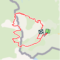
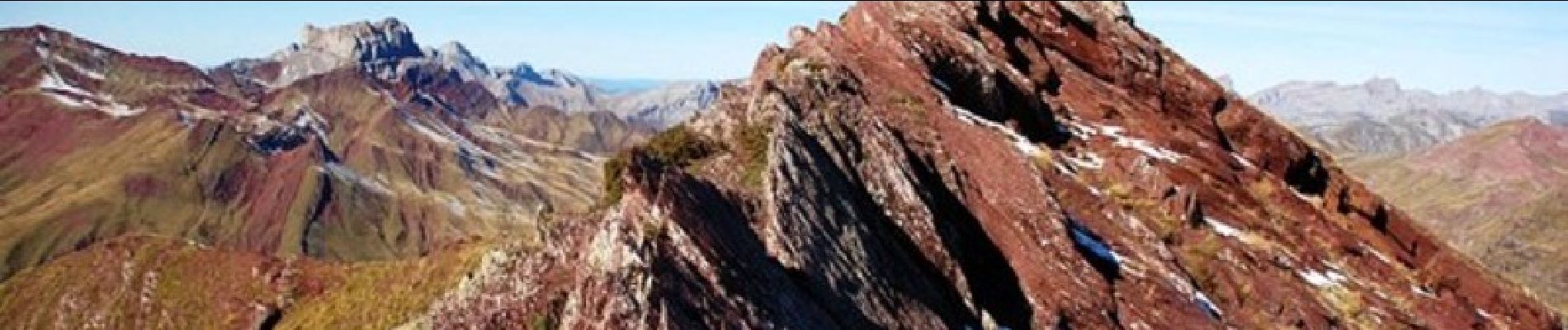
Pic Gabedaille 2258m depuis parking d'Espélunguère (1350m) Malgré son altitude modeste, le pic de Gabedaille (ou signal d'Espélunguère) constitue un exceptionnel belvédère. Peu de circuits aussi courts offrent à la fois une telle variété de paysages et un panorama aussi somptueux. Difficulté: Aucune en aller retour, mais des pentes raides quand on désire revenir en circuit où il faut éviter des parois rocheuses vers 1900m (Pour randonneur expérimenté). D’autres indications, photos et panoramiques sur le site « Les Pyrénées vues par Mariano ».
Localisation
Commentaires
Randonnées à proximité
![Randonnée A pied Urdos - Sentier de Peyranère au Refuge de Larry PNP - Photo](https://media.geolcdn.com/t/375/260/12d86d0c-9ae8-4a0a-b713-61ee3738bf3b.jpeg&format=jpg&maxdim=2)
![A pied A pied](https://static1.geolcdn.com/sitytour/trail-icons/100.png)
A pied
![](/images/other/stat-length.png)
![](https://static1.geolcdn.com/siteimages/upload/files/16400158638029165_repeat_loop_refresh_sync_direction_icon.png)
![Randonnée A pied Urdos - Sentier du Plateau de la Gentiane PNP - Photo](https://media.geolcdn.com/t/375/260/12d86d0c-9ae8-4a0a-b713-61ee3738bf3b.jpeg&format=jpg&maxdim=2)
![A pied A pied](https://static1.geolcdn.com/sitytour/trail-icons/100.png)
A pied
![](/images/other/stat-length.png)
![](https://static1.geolcdn.com/siteimages/upload/files/16400158638029165_repeat_loop_refresh_sync_direction_icon.png)
![Randonnée A pied Urdos - Sentier du Lac d'Estaëns PNP - Photo](https://media.geolcdn.com/t/375/260/f2b54571-15e4-4669-844e-6d4a7160a93e.jpeg&format=jpg&maxdim=2)
![A pied A pied](https://static1.geolcdn.com/sitytour/trail-icons/100.png)
A pied
![](/images/other/stat-length.png)
![](https://static1.geolcdn.com/siteimages/upload/files/16400158638029165_repeat_loop_refresh_sync_direction_icon.png)
![Randonnée Marche Borce - Boucle Lescun 4J - E4 - Photo](https://media.geolcdn.com/t/375/260/ext.jpg?maxdim=2&url=https%3A%2F%2Fstatic1.geolcdn.com%2Fsiteimages%2Fupload%2Ffiles%2F1553511878bg_sport_marche.png)
![Marche Marche](https://static1.geolcdn.com/sitytour/trail-icons/101.png)
Marche
![](/images/other/stat-length.png)
![](https://static1.geolcdn.com/siteimages/upload/files/16400158638029165_repeat_loop_refresh_sync_direction_icon.png)
![Randonnée Marche Borce - hrp Arlet to candanchu - Photo](https://media.geolcdn.com/t/375/260/ext.jpg?maxdim=2&url=https%3A%2F%2Fstatic1.geolcdn.com%2Fsiteimages%2Fupload%2Ffiles%2F1553511878bg_sport_marche.png)
![Marche Marche](https://static1.geolcdn.com/sitytour/trail-icons/101.png)
Marche
![](/images/other/stat-length.png)
![](https://static1.geolcdn.com/siteimages/upload/files/16400158638029165_repeat_loop_refresh_sync_direction_icon.png)
![Randonnée Marche Borce - Chemin de l'escalé - Photo](https://media.geolcdn.com/t/375/260/a66f4049-6310-4965-a5bd-700ca57594e4.jpg&format=jpg&maxdim=2)
![Marche Marche](https://static1.geolcdn.com/sitytour/trail-icons/101.png)
Marche
![](/images/other/stat-length.png)
![](https://static1.geolcdn.com/siteimages/upload/files/16400158638029165_repeat_loop_refresh_sync_direction_icon.png)
![Randonnée Marche Borce - Lac d'Estaens - Photo](https://media.geolcdn.com/t/375/260/1c0d5bd9-b4bf-4d4c-82d2-78a185a6a0dd.jpg&format=jpg&maxdim=2)
![Marche Marche](https://static1.geolcdn.com/sitytour/trail-icons/101.png)
Marche
![](/images/other/stat-length.png)
![](https://static1.geolcdn.com/siteimages/upload/files/16400158638029165_repeat_loop_refresh_sync_direction_icon.png)
![Randonnée Marche Urdos - Plateau de la gentiane - Photo](https://media.geolcdn.com/t/375/260/b1985722-4b53-4d00-9ae9-e27a98bdc95b.jpg&format=jpg&maxdim=2)
![Marche Marche](https://static1.geolcdn.com/sitytour/trail-icons/101.png)
Marche
![](/images/other/stat-length.png)
![](https://static1.geolcdn.com/siteimages/upload/files/16400158638029165_repeat_loop_refresh_sync_direction_icon.png)
![Randonnée Marche Urdos - Lac d'Estaens et environs - Photo](https://media.geolcdn.com/t/375/260/795b0e28-1fa9-4eb7-baf6-c4a84979127a.jpg&format=jpg&maxdim=2)
![Marche Marche](https://static1.geolcdn.com/sitytour/trail-icons/101.png)
Marche
![](/images/other/stat-length.png)
![](https://static1.geolcdn.com/siteimages/upload/files/16400158638029165_repeat_loop_refresh_sync_direction_icon.png)