![](/images/other/stat-length.png)
![Randonnée Marche Mornas - Mornas la citadelle fortifiée - Photo](https://media.geolcdn.com/t/1900/400/ext.pjpeg?maxdim=2&url=https%3A%2F%2Fservices.sitytrail.com%2FGeolivesWS%2FDownloadMedia.ashx%3FTrailID%3D109892%26Media%3D4899_1.jpg)
Mornas la citadelle fortifiée
tracegps
Utilisateur
![Longueur](/images/other/stat-length.png)
Longueur
6,6 km
![Altitude max](https://static1.geolcdn.com/siteimages/upload/files/1508320355ic_sort_altitude_max_24dp.png)
Altitude max
186 m
![Dénivelé positif](https://static1.geolcdn.com/siteimages/upload/files/1508320355ic_sort_den_pos_24dp.png)
Dénivelé positif
159 m
![Km-Effort](/images/other/stat-length.png)
Km-Effort
8,7 km
![Altitude min](https://static1.geolcdn.com/siteimages/upload/files/1508320355ic_sort_altitude_min_24dp.png)
Altitude min
37 m
![Dénivelé négatif](https://static1.geolcdn.com/siteimages/upload/files/1508320355ic_sort_den_neg_24dp.png)
Dénivelé négatif
156 m
![Boucle](https://static1.geolcdn.com/siteimages/upload/files/16400158638029165_repeat_loop_refresh_sync_direction_icon.png)
Boucle
Oui
Date de création :
2014-12-10 00:00:00.0
Dernière modification :
2014-12-10 00:00:00.0
![Marche](https://static1.geolcdn.com/sitytour/trail-icons/101.png)
1h30
Difficulté : Moyen
![Scannez ce code QR pour ouvrir la randonnée dans l'application SityTrail](https://capi.geolives.com/qq0zvz2zws4bq2lad0pu/sitytour/trails/109892/qr.png?size=200)
Application GPS de randonnée GRATUITE
À propos
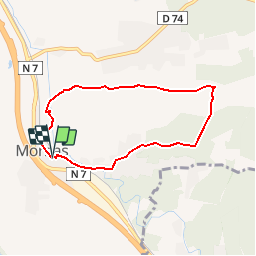
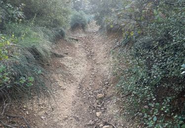
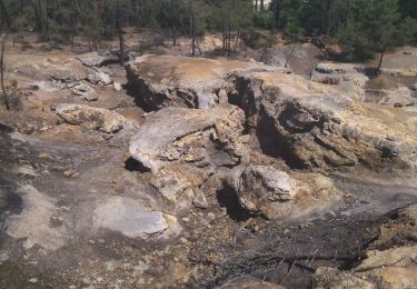
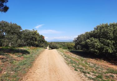
Randonnée Marche de 6,6 km à découvrir à Provence-Alpes-Côte d'Azur, Vaucluse, Mornas. Cette randonnée est proposée par tracegps.
Description
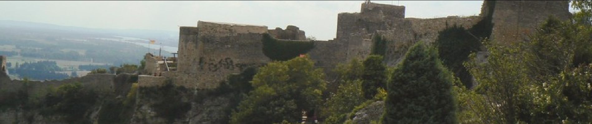
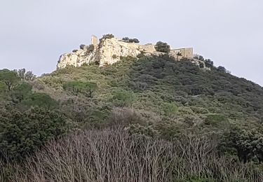
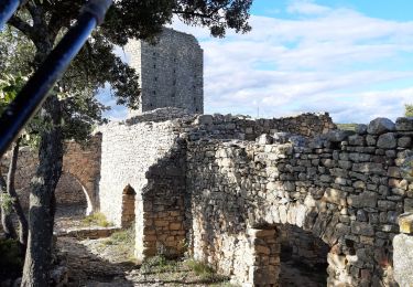
A Mornas se garer au centre ou dans une rue transversale puis rejoindre à pied la forteresse ou une association la fait visiter en costumes les dimanche… La suite et d’autres informations et photos sur le site des Balades de Stéphane.
Localisation
Pays :
France
Région :
Provence-Alpes-Côte d'Azur
Département/Province :
Vaucluse
Commune :
Mornas
Localité :
Unknown
Départ:(Dec)
Départ:(UTM)
638269 ; 4895565 (31T) N.
Commentaires
Randonnées à proximité
![Randonnée Marche Mondragon - mondragon - Photo](https://media.geolcdn.com/t/375/260/ext.jpg?maxdim=2&url=https%3A%2F%2Fservices.sitytrail.com%2FGeolivesWS%2FDownloadMedia.ashx%3FTrailID%3D157351%26Media%3D20121007163028.jpeg)
![Marche Marche](https://static1.geolcdn.com/sitytour/trail-icons/101.png)
mondragon
Marche
Facile
(1)
Mondragon,
Provence-Alpes-Côte d'Azur,
Vaucluse,
France
![](/images/other/stat-length.png)
8,3 km | 9,4 km-effort
2h 4min
![](https://static1.geolcdn.com/siteimages/upload/files/16400158638029165_repeat_loop_refresh_sync_direction_icon.png)
Oui
![Randonnée Marche Piolenc - Piolenc-Les Grottes-Chapelle St Baudile-Ancienne Forteresse de Mornas 16km. - Photo](https://media.geolcdn.com/t/375/260/61b7e981-6de5-4ae1-9510-367c462a11dd.jpg&format=jpg&maxdim=2)
![Marche Marche](https://static1.geolcdn.com/sitytour/trail-icons/101.png)
Piolenc-Les Grottes-Chapelle St Baudile-Ancienne Forteresse de Mornas 16km.
Marche
Très difficile
Piolenc,
Provence-Alpes-Côte d'Azur,
Vaucluse,
France
![](/images/other/stat-length.png)
15,7 km | 20 km-effort
4h 36min
![](https://static1.geolcdn.com/siteimages/upload/files/16400158638029165_repeat_loop_refresh_sync_direction_icon.png)
Oui
![Randonnée Marche Mondragon - Mondragon -Mornas - Photo](https://media.geolcdn.com/t/375/260/ext.jpg?maxdim=2&url=https%3A%2F%2Fstatic1.geolcdn.com%2Fsiteimages%2Fupload%2Ffiles%2F1553511878bg_sport_marche.png)
![Marche Marche](https://static1.geolcdn.com/sitytour/trail-icons/101.png)
Mondragon -Mornas
Marche
Très facile
(1)
Mondragon,
Provence-Alpes-Côte d'Azur,
Vaucluse,
France
![](/images/other/stat-length.png)
16,3 km | 21 km-effort
4h 28min
![](https://static1.geolcdn.com/siteimages/upload/files/16400158638029165_repeat_loop_refresh_sync_direction_icon.png)
Oui
![Randonnée Marche Piolenc - Piolenc - Valbonnette - La Barjavelle - Photo](https://media.geolcdn.com/t/375/260/ext.jpg?maxdim=2&url=https%3A%2F%2Fstatic1.geolcdn.com%2Fsiteimages%2Fupload%2Ffiles%2F1553511878bg_sport_marche.png)
![Marche Marche](https://static1.geolcdn.com/sitytour/trail-icons/101.png)
Piolenc - Valbonnette - La Barjavelle
Marche
Moyen
(1)
Piolenc,
Provence-Alpes-Côte d'Azur,
Vaucluse,
France
![](/images/other/stat-length.png)
9,1 km | 11,6 km-effort
2h 40min
![](https://static1.geolcdn.com/siteimages/upload/files/16400158638029165_repeat_loop_refresh_sync_direction_icon.png)
Oui
![Randonnée sport Mornas - Forteresse de Mornas - Photo](https://media.geolcdn.com/t/375/260/87219c3e-9efc-4784-874e-d7e6cc75fcf5.jpg&format=jpg&maxdim=2)
Forteresse de Mornas
sport
Très facile
Mornas,
Provence-Alpes-Côte d'Azur,
Vaucluse,
France
![](/images/other/stat-length.png)
5,1 km | 7,1 km-effort
Inconnu
![](https://static1.geolcdn.com/siteimages/upload/files/16400158638029165_repeat_loop_refresh_sync_direction_icon.png)
Oui
![Randonnée Marche Piolenc - 84 st montant zel - Photo](https://media.geolcdn.com/t/375/260/a1f357ba-4623-424b-9382-89748cf0f104.jpg&format=jpg&maxdim=2)
![Marche Marche](https://static1.geolcdn.com/sitytour/trail-icons/101.png)
84 st montant zel
Marche
Facile
Piolenc,
Provence-Alpes-Côte d'Azur,
Vaucluse,
France
![](/images/other/stat-length.png)
14,6 km | 19,4 km-effort
6h 1min
![](https://static1.geolcdn.com/siteimages/upload/files/16400158638029165_repeat_loop_refresh_sync_direction_icon.png)
Oui
![Randonnée Marche Chusclan - CHUSCLAN - Fontaine du Renard - GICON - VENEJAN - Photo](https://media.geolcdn.com/t/375/260/f20695c6-1441-4e27-84cc-14bf71fed7cc.jpg&format=jpg&maxdim=2)
![Marche Marche](https://static1.geolcdn.com/sitytour/trail-icons/101.png)
CHUSCLAN - Fontaine du Renard - GICON - VENEJAN
Marche
Très difficile
Chusclan,
Occitanie,
Gard,
France
![](/images/other/stat-length.png)
15,3 km | 19,7 km-effort
6h 4min
![](https://static1.geolcdn.com/siteimages/upload/files/16400158638029165_repeat_loop_refresh_sync_direction_icon.png)
Oui
![Randonnée Marche Chusclan - Venejan_041121 - Photo](https://media.geolcdn.com/t/375/260/4cfa55b5-1d84-4de3-9c6d-6ae353305679.jpg&format=jpg&maxdim=2)
![Marche Marche](https://static1.geolcdn.com/sitytour/trail-icons/101.png)
Venejan_041121
Marche
Très difficile
Chusclan,
Occitanie,
Gard,
France
![](/images/other/stat-length.png)
14,8 km | 19 km-effort
4h 19min
![](https://static1.geolcdn.com/siteimages/upload/files/16400158638029165_repeat_loop_refresh_sync_direction_icon.png)
Oui
![Randonnée Marche Piolenc - Piolenc, Mornas - Photo](https://media.geolcdn.com/t/375/260/abaef2ea-8207-47d9-a2bd-5c1d0d5de356.jpg&format=jpg&maxdim=2)
![Marche Marche](https://static1.geolcdn.com/sitytour/trail-icons/101.png)
Piolenc, Mornas
Marche
Facile
(1)
Piolenc,
Provence-Alpes-Côte d'Azur,
Vaucluse,
France
![](/images/other/stat-length.png)
10,8 km | 13,5 km-effort
2h 34min
![](https://static1.geolcdn.com/siteimages/upload/files/16400158638029165_repeat_loop_refresh_sync_direction_icon.png)
Oui
Merci , belle rando autours de Mornas