![](/images/other/stat-length.png)
![Randonnée Marche Saint-Remèze - Rapide de Gournier - Dolmen du Chanet - Photo](https://media.geolcdn.com/t/1900/400/ext.pjpeg?maxdim=2&url=https%3A%2F%2Fservices.sitytrail.com%2FGeolivesWS%2FDownloadMedia.ashx%3FTrailID%3D109890%26Media%3D4897_1.jpg)
Rapide de Gournier - Dolmen du Chanet
tracegps
Utilisateur
![Longueur](/images/other/stat-length.png)
Longueur
5,9 km
![Altitude max](https://static1.geolcdn.com/siteimages/upload/files/1508320355ic_sort_altitude_max_24dp.png)
Altitude max
316 m
![Dénivelé positif](https://static1.geolcdn.com/siteimages/upload/files/1508320355ic_sort_den_pos_24dp.png)
Dénivelé positif
260 m
![Km-Effort](/images/other/stat-length.png)
Km-Effort
9,4 km
![Altitude min](https://static1.geolcdn.com/siteimages/upload/files/1508320355ic_sort_altitude_min_24dp.png)
Altitude min
67 m
![Dénivelé négatif](https://static1.geolcdn.com/siteimages/upload/files/1508320355ic_sort_den_neg_24dp.png)
Dénivelé négatif
260 m
![Boucle](https://static1.geolcdn.com/siteimages/upload/files/16400158638029165_repeat_loop_refresh_sync_direction_icon.png)
Boucle
Oui
Date de création :
2014-12-10 00:00:00.0
Dernière modification :
2014-12-10 00:00:00.0
![Marche](https://static1.geolcdn.com/sitytour/trail-icons/101.png)
2h30
Difficulté : Difficile
![Scannez ce code QR pour ouvrir la randonnée dans l'application SityTrail](https://capi.geolives.com/qq0zvz2zws4bq2lad0pu/sitytour/trails/109890/qr.png?size=200)
Application GPS de randonnée GRATUITE
À propos
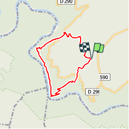
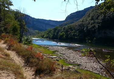
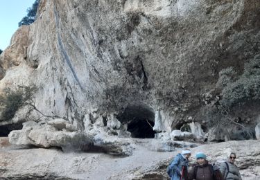
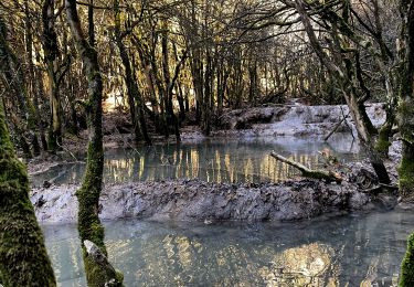
Randonnée Marche de 5,9 km à découvrir à Auvergne-Rhône-Alpes, Ardèche, Saint-Remèze. Cette randonnée est proposée par tracegps.
Description
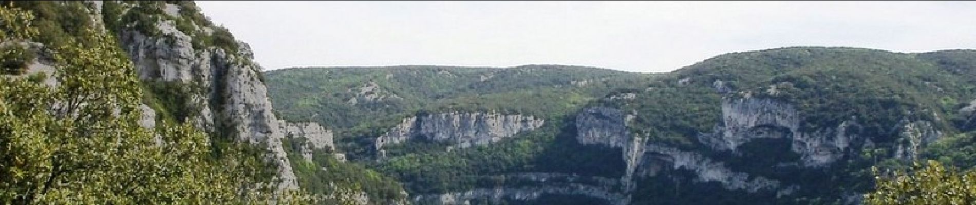
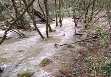
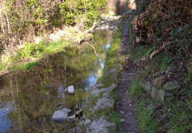
Promenade dans les gorges de l'Ardèche au rapide de Gournier en passant par le dolmen du Chanet. La suite et d’autres informations et photos sur le site des Balades de Stéphane.
Localisation
Pays :
France
Région :
Auvergne-Rhône-Alpes
Département/Province :
Ardèche
Commune :
Saint-Remèze
Localité :
Unknown
Départ:(Dec)
Départ:(UTM)
617938 ; 4911833 (31T) N.
Commentaires
Randonnées à proximité
![Randonnée Marche Saint-Remèze - 07 st remède tioure pissevieille 11 05 2021 - Photo](https://media.geolcdn.com/t/375/260/9fecb482-19aa-4b9b-88b5-916cfbc2710b.jpg&format=jpg&maxdim=2)
![Marche Marche](https://static1.geolcdn.com/sitytour/trail-icons/101.png)
07 st remède tioure pissevieille 11 05 2021
Marche
Moyen
(1)
Saint-Remèze,
Auvergne-Rhône-Alpes,
Ardèche,
France
![](/images/other/stat-length.png)
18,4 km | 28 km-effort
7h 34min
![](https://static1.geolcdn.com/siteimages/upload/files/16400158638029165_repeat_loop_refresh_sync_direction_icon.png)
Oui
![Randonnée Marche Labastide-de-Virac - 07 gorges ardeche - Photo](https://media.geolcdn.com/t/375/260/ext.jpg?maxdim=2&url=https%3A%2F%2Fstatic1.geolcdn.com%2Fsiteimages%2Fupload%2Ffiles%2F1553511878bg_sport_marche.png)
![Marche Marche](https://static1.geolcdn.com/sitytour/trail-icons/101.png)
07 gorges ardeche
Marche
Facile
(1)
Labastide-de-Virac,
Auvergne-Rhône-Alpes,
Ardèche,
France
![](/images/other/stat-length.png)
13,7 km | 22 km-effort
5h 5min
![](https://static1.geolcdn.com/siteimages/upload/files/16400158638029165_repeat_loop_refresh_sync_direction_icon.png)
Oui
![Randonnée Marche Labastide-de-Virac - les gorges de l'Ardèche - Photo](https://media.geolcdn.com/t/375/260/22a42236-31e2-4521-b8d2-19cd765eb1ce.jpg&format=jpg&maxdim=2)
![Marche Marche](https://static1.geolcdn.com/sitytour/trail-icons/101.png)
les gorges de l'Ardèche
Marche
Moyen
Labastide-de-Virac,
Auvergne-Rhône-Alpes,
Ardèche,
France
![](/images/other/stat-length.png)
8,9 km | 14,1 km-effort
5h 14min
![](https://static1.geolcdn.com/siteimages/upload/files/16400158638029165_repeat_loop_refresh_sync_direction_icon.png)
Oui
![Randonnée Marche Vallon-Pont-d'Arc - Vallon pont d'arc au bivouac du gournier - Photo](https://media.geolcdn.com/t/375/260/086bf84f-df3e-4a5f-9662-b644951d7f29.jpg&format=jpg&maxdim=2)
![Marche Marche](https://static1.geolcdn.com/sitytour/trail-icons/101.png)
Vallon pont d'arc au bivouac du gournier
Marche
Moyen
Vallon-Pont-d'Arc,
Auvergne-Rhône-Alpes,
Ardèche,
France
![](/images/other/stat-length.png)
18,8 km | 31 km-effort
3h 45min
![](https://static1.geolcdn.com/siteimages/upload/files/16400158638029165_repeat_loop_refresh_sync_direction_icon.png)
Non
![Randonnée Marche Saint-Remèze - 07 st remeze saut du loup - Photo](https://media.geolcdn.com/t/375/260/9c861e3e-f865-42fc-aaf5-e2bd0f243cd5.jpg&format=jpg&maxdim=2)
![Marche Marche](https://static1.geolcdn.com/sitytour/trail-icons/101.png)
07 st remeze saut du loup
Marche
Moyen
Saint-Remèze,
Auvergne-Rhône-Alpes,
Ardèche,
France
![](/images/other/stat-length.png)
16 km | 23 km-effort
4h 19min
![](https://static1.geolcdn.com/siteimages/upload/files/16400158638029165_repeat_loop_refresh_sync_direction_icon.png)
Oui
![Randonnée Marche Vallon-Pont-d'Arc - Vallon-Pont-d'Arc - Gorges de l'Ardèche de Chames au Gué de Charmassonnet AR - 9.9km 360m 3h05 - 2014 09 13 - Photo](https://media.geolcdn.com/t/375/260/ext.jpg?maxdim=2&url=https%3A%2F%2Fservices.sitytrail.com%2FGeolivesWS%2FDownloadMedia.ashx%3FTrailID%3D345720%26Media%3Dfix__20140913104619.jpg)
![Marche Marche](https://static1.geolcdn.com/sitytour/trail-icons/101.png)
Vallon-Pont-d'Arc - Gorges de l'Ardèche de Chames au Gué de Charmassonnet AR ...
Marche
Facile
(1)
Vallon-Pont-d'Arc,
Auvergne-Rhône-Alpes,
Ardèche,
France
![](/images/other/stat-length.png)
9,9 km | 14,6 km-effort
3h 5min
![](https://static1.geolcdn.com/siteimages/upload/files/16400158638029165_repeat_loop_refresh_sync_direction_icon.png)
Oui
![Randonnée Marche Saint-Remèze - St REMEZE, Grottes, gorges de l'Ardèche, dolmen du Chanet - Photo](https://media.geolcdn.com/t/375/260/8422d16e-cbc7-4232-99de-73c54000c1c0.jpg&format=jpg&maxdim=2)
![Marche Marche](https://static1.geolcdn.com/sitytour/trail-icons/101.png)
St REMEZE, Grottes, gorges de l'Ardèche, dolmen du Chanet
Marche
Difficile
Saint-Remèze,
Auvergne-Rhône-Alpes,
Ardèche,
France
![](/images/other/stat-length.png)
8,1 km | 12,8 km-effort
2h 54min
![](https://static1.geolcdn.com/siteimages/upload/files/16400158638029165_repeat_loop_refresh_sync_direction_icon.png)
Oui
![Randonnée Marche Vallon-Pont-d'Arc - Chames - Vallon de Tiourre - Photo](https://media.geolcdn.com/t/375/260/ad153c33-6d23-46e4-9fee-0956befc1f93.jpg&format=jpg&maxdim=2)
![Marche Marche](https://static1.geolcdn.com/sitytour/trail-icons/101.png)
Chames - Vallon de Tiourre
Marche
Difficile
Vallon-Pont-d'Arc,
Auvergne-Rhône-Alpes,
Ardèche,
France
![](/images/other/stat-length.png)
11,3 km | 16,6 km-effort
3h 39min
![](https://static1.geolcdn.com/siteimages/upload/files/16400158638029165_repeat_loop_refresh_sync_direction_icon.png)
Oui
![Randonnée Marche Labastide-de-Virac - Labastide-de-virac](https://media.geolcdn.com/t/375/260/4a8edbc3-dff2-4936-8e03-e46bae59b84a.jpg&format=jpg&maxdim=2)
![Marche Marche](https://static1.geolcdn.com/sitytour/trail-icons/101.png)
Labastide-de-virac "Les Crottes "14km.
Marche
Très difficile
Labastide-de-Virac,
Auvergne-Rhône-Alpes,
Ardèche,
France
![](/images/other/stat-length.png)
13,6 km | 19,4 km-effort
4h 24min
![](https://static1.geolcdn.com/siteimages/upload/files/16400158638029165_repeat_loop_refresh_sync_direction_icon.png)
Oui
Bien j'aimerai pouvoir preparer une randonnée