![](/images/other/stat-length.png)
![Randonnée Marche Valaurie - Valaurie - Photo](https://media.geolcdn.com/t/1900/400/ext.pjpeg?maxdim=2&url=https%3A%2F%2Fservices.sitytrail.com%2FGeolivesWS%2FDownloadMedia.ashx%3FTrailID%3D109884%26Media%3D4889_1.jpg)
Valaurie
tracegps
Utilisateur
![Longueur](/images/other/stat-length.png)
![Altitude max](https://static1.geolcdn.com/siteimages/upload/files/1508320355ic_sort_altitude_max_24dp.png)
![Dénivelé positif](https://static1.geolcdn.com/siteimages/upload/files/1508320355ic_sort_den_pos_24dp.png)
![Km-Effort](/images/other/stat-length.png)
![Altitude min](https://static1.geolcdn.com/siteimages/upload/files/1508320355ic_sort_altitude_min_24dp.png)
![Dénivelé négatif](https://static1.geolcdn.com/siteimages/upload/files/1508320355ic_sort_den_neg_24dp.png)
![Boucle](https://static1.geolcdn.com/siteimages/upload/files/16400158638029165_repeat_loop_refresh_sync_direction_icon.png)
![Marche](https://static1.geolcdn.com/sitytour/trail-icons/101.png)
1h40
Difficulté : Moyen
![Scannez ce code QR pour ouvrir la randonnée dans l'application SityTrail](https://capi.geolives.com/qq0zvz2zws4bq2lad0pu/sitytour/trails/109884/qr.png?size=200)
Application GPS de randonnée GRATUITE
À propos
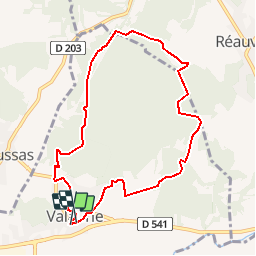
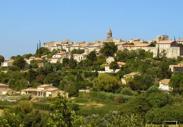
Randonnée Marche de 9 km à découvrir à Auvergne-Rhône-Alpes, Drôme, Valaurie. Cette randonnée est proposée par tracegps.
Description
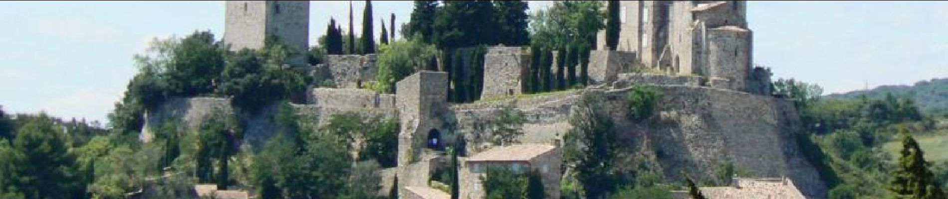
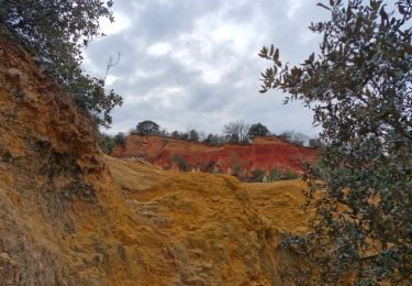
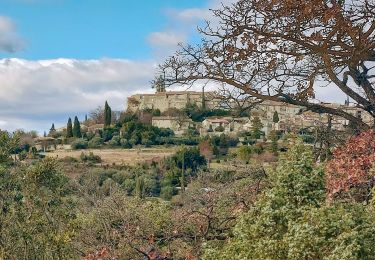
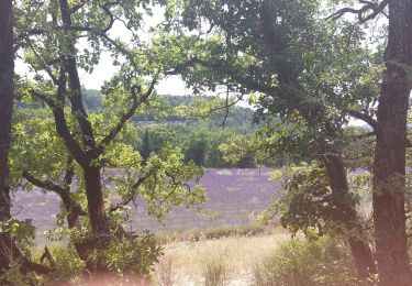
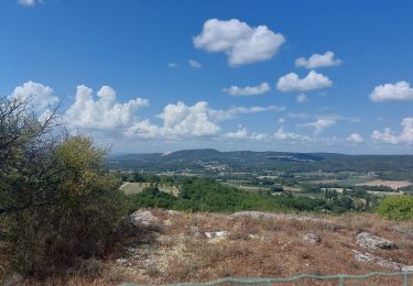
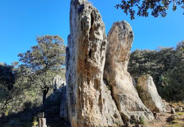
De Valaurie au parking en dessous de l'église on traverse le village de maisons en pierres de taille en suivant le balisage jaune, nous partons vers les forêts de pins alep et un tour agréable avec point de vue sur Roussas puis la crevasse de Chantemerle nous ramène vers le village perché de Valaurie. D’autres informations et photos sur le site des Balades de Stéphane.
Localisation
Commentaires
Randonnées à proximité
![Randonnée Marche La Garde-Adhémar - La Garde-Adhemar Le Val des Nymphes Les Ocres 13km. - Photo](https://media.geolcdn.com/t/375/260/f22fd23a-4662-459b-bd1b-f7844383ab69.jpg&format=jpg&maxdim=2)
![Marche Marche](https://static1.geolcdn.com/sitytour/trail-icons/101.png)
Marche
![](/images/other/stat-length.png)
![](https://static1.geolcdn.com/siteimages/upload/files/16400158638029165_repeat_loop_refresh_sync_direction_icon.png)
![Randonnée Marche Clansayes - Clansayes Le Rouvergue 7km - Photo](https://media.geolcdn.com/t/375/260/de3feb6f-5587-4e87-a580-1261cf3df48e.jpg&format=jpg&maxdim=2)
![Marche Marche](https://static1.geolcdn.com/sitytour/trail-icons/101.png)
Marche
![](/images/other/stat-length.png)
![](https://static1.geolcdn.com/siteimages/upload/files/16400158638029165_repeat_loop_refresh_sync_direction_icon.png)
![Randonnée Marche La Garde-Adhémar - La Garde-Adhemar Val- des-Nymphes. 8,5km - Photo](https://media.geolcdn.com/t/375/260/05b3cab3-21bf-4624-90c5-6a3af96daa1d.jpg&format=jpg&maxdim=2)
![Marche Marche](https://static1.geolcdn.com/sitytour/trail-icons/101.png)
Marche
![](/images/other/stat-length.png)
![](https://static1.geolcdn.com/siteimages/upload/files/16400158638029165_repeat_loop_refresh_sync_direction_icon.png)
![Randonnée Marche Roussas - Roussas le Vernet 10km. - Photo](https://media.geolcdn.com/t/375/260/69de5ff3-2ab5-4bbd-b379-bc7253ad9aad.jpg&format=jpg&maxdim=2)
![Marche Marche](https://static1.geolcdn.com/sitytour/trail-icons/101.png)
Marche
![](/images/other/stat-length.png)
![](https://static1.geolcdn.com/siteimages/upload/files/16400158638029165_repeat_loop_refresh_sync_direction_icon.png)
![Randonnée Marche Chantemerle-lès-Grignan - Chantemerle -lès-Grignan Les crevasses Le Rouvergue 14km - Photo](https://media.geolcdn.com/t/375/260/831a71a9-7103-4579-b58f-a481dab0e6f2.jpg&format=jpg&maxdim=2)
![Marche Marche](https://static1.geolcdn.com/sitytour/trail-icons/101.png)
Marche
![](/images/other/stat-length.png)
![](https://static1.geolcdn.com/siteimages/upload/files/16400158638029165_repeat_loop_refresh_sync_direction_icon.png)
![Randonnée Marche Réauville - Reauville Aiguebelle Cascacades 10km - Photo](https://media.geolcdn.com/t/375/260/c8066850-a8b6-4767-b8cc-00eee53525df.jpg&format=jpg&maxdim=2)
![Marche Marche](https://static1.geolcdn.com/sitytour/trail-icons/101.png)
Marche
![](/images/other/stat-length.png)
![](https://static1.geolcdn.com/siteimages/upload/files/16400158638029165_repeat_loop_refresh_sync_direction_icon.png)
![Randonnée Marche Chantemerle-lès-Grignan - Les Crevasses de Chantemerle Les Grignans 7Km5 - Photo](https://media.geolcdn.com/t/375/260/cedb0d20-c0ad-495a-acf8-00c291c6b1fd.jpg&format=jpg&maxdim=2)
![Marche Marche](https://static1.geolcdn.com/sitytour/trail-icons/101.png)
Marche
![](/images/other/stat-length.png)
![](https://static1.geolcdn.com/siteimages/upload/files/16400158638029165_repeat_loop_refresh_sync_direction_icon.png)
![Randonnée Marche Chantemerle-lès-Grignan - Chantemerle-Les Grignan Les jumelles du Rozet Clansayes 15km - Photo](https://media.geolcdn.com/t/375/260/e778a7ff-aae4-45e1-a529-5e7212fd1471.jpg&format=jpg&maxdim=2)
![Marche Marche](https://static1.geolcdn.com/sitytour/trail-icons/101.png)
Marche
![](/images/other/stat-length.png)
![](https://static1.geolcdn.com/siteimages/upload/files/16400158638029165_repeat_loop_refresh_sync_direction_icon.png)
![Randonnée Marche Roussas - Roussas Panassas 8 km - Photo](https://media.geolcdn.com/t/375/260/daa93b3b-e486-4ddd-9c21-8f099d0a496e.jpg&format=jpg&maxdim=2)
![Marche Marche](https://static1.geolcdn.com/sitytour/trail-icons/101.png)
Marche
![](/images/other/stat-length.png)
![](https://static1.geolcdn.com/siteimages/upload/files/16400158638029165_repeat_loop_refresh_sync_direction_icon.png)