![](/images/other/stat-length.png)
![Randonnée Vélo Crécy-en-Ponthieu - Au nord de la Baie de Somme - Circuit du Geai - Crécy en Ponthieu - Photo](https://media.geolcdn.com/t/1900/400/ext.pjpeg?maxdim=2&url=https%3A%2F%2Fservices.sitytrail.com%2FGeolivesWS%2FDownloadMedia.ashx%3FTrailID%3D109864%26Media%3D4851_1.jpg)
Au nord de la Baie de Somme - Circuit du Geai - Crécy en Ponthieu
tracegps
Utilisateur
![Longueur](/images/other/stat-length.png)
![Altitude max](https://static1.geolcdn.com/siteimages/upload/files/1508320355ic_sort_altitude_max_24dp.png)
![Dénivelé positif](https://static1.geolcdn.com/siteimages/upload/files/1508320355ic_sort_den_pos_24dp.png)
![Km-Effort](/images/other/stat-length.png)
![Altitude min](https://static1.geolcdn.com/siteimages/upload/files/1508320355ic_sort_altitude_min_24dp.png)
![Dénivelé négatif](https://static1.geolcdn.com/siteimages/upload/files/1508320355ic_sort_den_neg_24dp.png)
![Boucle](https://static1.geolcdn.com/siteimages/upload/files/16400158638029165_repeat_loop_refresh_sync_direction_icon.png)
![Vélo](https://static1.geolcdn.com/sitytour/trail-icons/200.png)
1h40
Difficulté : Moyen
![Scannez ce code QR pour ouvrir la randonnée dans l'application SityTrail](https://capi.geolives.com/qq0zvz2zws4bq2lad0pu/sitytour/trails/109864/qr.png?size=200)
Application GPS de randonnée GRATUITE
À propos
Randonnée Vélo de 17,5 km à découvrir à Hauts-de-France, Somme, Crécy-en-Ponthieu. Cette randonnée est proposée par tracegps.
Description
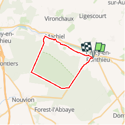
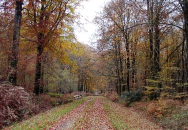
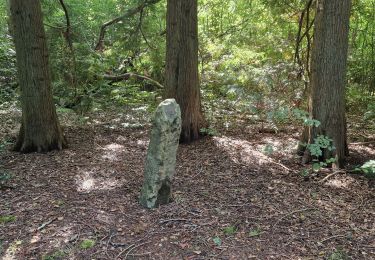
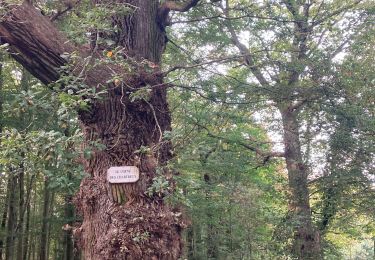
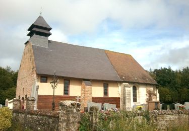
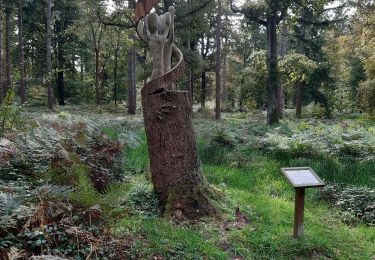
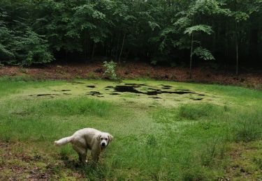
Au nord de la Baie de Somme - Circuit du Geai - Crécy en Ponthieu Découvrez la forêt de Crécy et ses arbres remarquables, mais aussi les marais et villages historiques du Ponthieu Marquenterre. Ce circuit est balisé par le Syndicat Mixte Baie de Somme Grand Littoral Picard. Au cours des parcours, vous emprunterez des pistes cyclables créées et entretenues par le Syndicat Mixte Baie de Somme Grand Littoral Picard. Vous partagez ces espaces avec d’autres usagers, respectez le code de la route, restez courtois et respectueux !
Localisation
Commentaires
Randonnées à proximité
![Randonnée Vélo Crécy-en-Ponthieu - Les Vieux Chênes - Crécy en Ponthieu - Photo](https://media.geolcdn.com/t/375/260/ext.jpg?maxdim=2&url=https%3A%2F%2Fservices.sitytrail.com%2FGeolivesWS%2FDownloadMedia.ashx%3FTrailID%3D109915%26Media%3D4931_1.jpg)
![Vélo Vélo](https://static1.geolcdn.com/sitytour/trail-icons/200.png)
Vélo
![](/images/other/stat-length.png)
![](https://static1.geolcdn.com/siteimages/upload/files/16400158638029165_repeat_loop_refresh_sync_direction_icon.png)
![Randonnée Marche Crécy-en-Ponthieu - Forêt de Crécy-en-Ponthieu - Photo](https://media.geolcdn.com/t/375/260/fd05b009-a0e0-48d9-b30d-737c848f8a0a.jpg&format=jpg&maxdim=2)
![Marche Marche](https://static1.geolcdn.com/sitytour/trail-icons/101.png)
Marche
![](/images/other/stat-length.png)
![](https://static1.geolcdn.com/siteimages/upload/files/16400158638029165_repeat_loop_refresh_sync_direction_icon.png)
![Randonnée V.T.T. Forest-l'Abbaye - Forest-l'Abbaye - Photo](https://media.geolcdn.com/t/375/260/9d218c20-19f9-4002-98b6-99eda2a32b95.png&format=jpg&maxdim=2)
![V.T.T. V.T.T.](https://static1.geolcdn.com/sitytour/trail-icons/202.png)
V.T.T.
![](/images/other/stat-length.png)
![](https://static1.geolcdn.com/siteimages/upload/files/16400158638029165_repeat_loop_refresh_sync_direction_icon.png)
![Randonnée Marche Forest-l'Abbaye - Forest l’Abbaye - Photo](https://media.geolcdn.com/t/375/260/23604bac-d1df-4fcb-bab6-ba45040d791e.jpg&format=jpg&maxdim=2)
![Marche Marche](https://static1.geolcdn.com/sitytour/trail-icons/101.png)
Marche
![](/images/other/stat-length.png)
![](https://static1.geolcdn.com/siteimages/upload/files/16400158638029165_repeat_loop_refresh_sync_direction_icon.png)
![Randonnée Marche Forest-l'Abbaye - LP80_Forest-L'Abbaye(arbres-remarquables+Scultures)_8km - Photo](https://media.geolcdn.com/t/375/260/8a9c9e06-a466-4037-92ca-f29b0b2e52d6.jpeg&format=jpg&maxdim=2)
![Marche Marche](https://static1.geolcdn.com/sitytour/trail-icons/101.png)
Marche
![](/images/other/stat-length.png)
![](https://static1.geolcdn.com/siteimages/upload/files/16400158638029165_repeat_loop_refresh_sync_direction_icon.png)
![Randonnée Marche Crécy-en-Ponthieu - Forêt de Crécy - Photo](https://media.geolcdn.com/t/375/260/f1b387ad-8151-48dc-8a2f-cae702cbbcd3.jpeg&format=jpg&maxdim=2)
![Marche Marche](https://static1.geolcdn.com/sitytour/trail-icons/101.png)
Marche
![](/images/other/stat-length.png)
![](https://static1.geolcdn.com/siteimages/upload/files/16400158638029165_repeat_loop_refresh_sync_direction_icon.png)
![Randonnée A pied Forest-l'Abbaye - Le Hallot - Photo](https://media.geolcdn.com/t/375/260/55088aac-3fac-47bc-a0c5-00e9894c90f2.jpeg&format=jpg&maxdim=2)
![A pied A pied](https://static1.geolcdn.com/sitytour/trail-icons/100.png)
A pied
![](/images/other/stat-length.png)
![](https://static1.geolcdn.com/siteimages/upload/files/16400158638029165_repeat_loop_refresh_sync_direction_icon.png)
![Randonnée Marche Crécy-en-Ponthieu - LP80_Crecy Ponthieu_Scultures bois - Photo](https://media.geolcdn.com/t/375/260/85252c58-db6b-4eda-bb40-73441ade40b9.jpg&format=jpg&maxdim=2)
![Marche Marche](https://static1.geolcdn.com/sitytour/trail-icons/101.png)
Marche
![](/images/other/stat-length.png)
![](https://static1.geolcdn.com/siteimages/upload/files/16400158638029165_repeat_loop_refresh_sync_direction_icon.png)
![Randonnée Marche Crécy-en-Ponthieu - forêt de Crecy - Photo](https://media.geolcdn.com/t/375/260/63501a4c-5e7d-4485-abe4-dbf7d7ae3149.jpg&format=jpg&maxdim=2)
![Marche Marche](https://static1.geolcdn.com/sitytour/trail-icons/101.png)
Marche
![](/images/other/stat-length.png)
![](https://static1.geolcdn.com/siteimages/upload/files/16400158638029165_repeat_loop_refresh_sync_direction_icon.png)