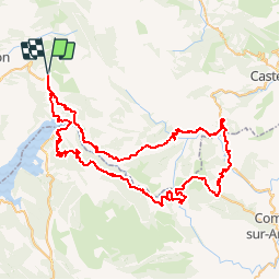
![](/images/other/stat-length.png)
![Randonnée Vélo Moustiers-Sainte-Marie - Tour des Gorges du Verdon - Photo](https://media.geolcdn.com/t/1900/400/ext.pjpeg?maxdim=2&url=https%3A%2F%2Fservices.sitytrail.com%2FGeolivesWS%2FDownloadMedia.ashx%3FTrailID%3D109835%26Media%3D4804_1.jpg)
Tour des Gorges du Verdon
tracegps
Utilisateur
![Longueur](/images/other/stat-length.png)
![Altitude max](https://static1.geolcdn.com/siteimages/upload/files/1508320355ic_sort_altitude_max_24dp.png)
![Dénivelé positif](https://static1.geolcdn.com/siteimages/upload/files/1508320355ic_sort_den_pos_24dp.png)
![Km-Effort](/images/other/stat-length.png)
![Altitude min](https://static1.geolcdn.com/siteimages/upload/files/1508320355ic_sort_altitude_min_24dp.png)
![Dénivelé négatif](https://static1.geolcdn.com/siteimages/upload/files/1508320355ic_sort_den_neg_24dp.png)
![Boucle](https://static1.geolcdn.com/siteimages/upload/files/16400158638029165_repeat_loop_refresh_sync_direction_icon.png)
![Vélo](https://static1.geolcdn.com/sitytour/trail-icons/200.png)
6h00
Difficulté : Difficile
![Scannez ce code QR pour ouvrir la randonnée dans l'application SityTrail](https://capi.geolives.com/qq0zvz2zws4bq2lad0pu/sitytour/trails/109835/qr.png?size=200)
Application GPS de randonnée GRATUITE
À propos
Randonnée Vélo de 89 km à découvrir à Provence-Alpes-Côte d'Azur, Alpes-de-Haute-Provence, Moustiers-Sainte-Marie. Cette randonnée est proposée par tracegps.
Description
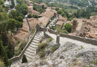
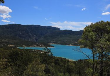
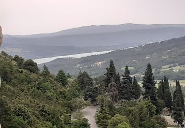
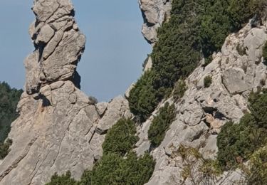
Tour des Gorges du Verdon. Montée par Aiguines et retour par Lapalud Le Club Cyclotouriste Malaucène Ventoux a 31 ans. Il regroupe les passionnés de la petite reine, de tous âges et de tous niveaux. Une ou deux sorties hebdomadaires sont effectuées tout au long de l'année, et une sortie randonnée sur plusieurs jours, généralement une semaine est accomplie chaque année. Découvrez notre club, et venez à notre rencontre à l'occasion de votre visite sur notre site.
Localisation
Commentaires
Randonnées à proximité
![Randonnée Marche Moustiers-Sainte-Marie - Tour des Gorges du Verdon - Photo](https://media.geolcdn.com/t/375/260/ext.jpg?maxdim=2&url=https%3A%2F%2Fstatic1.geolcdn.com%2Fsiteimages%2Fupload%2Ffiles%2F1553511878bg_sport_marche.png)
![Marche Marche](https://static1.geolcdn.com/sitytour/trail-icons/101.png)
Marche
![](/images/other/stat-length.png)
![](https://static1.geolcdn.com/siteimages/upload/files/16400158638029165_repeat_loop_refresh_sync_direction_icon.png)
![Randonnée Marche Moustiers-Sainte-Marie - Moustier Ravin Notre Dame crête de l’Ourbes 14,5 km - Photo](https://media.geolcdn.com/t/375/260/a74da90b-306e-4ee3-bd53-9babe310e6e2.jpg&format=jpg&maxdim=2)
![Marche Marche](https://static1.geolcdn.com/sitytour/trail-icons/101.png)
Marche
![](/images/other/stat-length.png)
![](https://static1.geolcdn.com/siteimages/upload/files/16400158638029165_repeat_loop_refresh_sync_direction_icon.png)
![Randonnée Marche Moustiers-Sainte-Marie - 2023-02-14 Les grottes de Saint Maurin - Photo](https://media.geolcdn.com/t/375/260/ff240215-b004-40c4-b632-ab00d837cb62.jpg&format=jpg&maxdim=2)
![Marche Marche](https://static1.geolcdn.com/sitytour/trail-icons/101.png)
Marche
![](/images/other/stat-length.png)
![](https://static1.geolcdn.com/siteimages/upload/files/16400158638029165_repeat_loop_refresh_sync_direction_icon.png)
![Randonnée Marche Moustiers-Sainte-Marie - Moustier saine Marie 11,4 km - Photo](https://media.geolcdn.com/t/375/260/325a0dcc-1ff8-4d2c-a406-91140305788f.jpeg&format=jpg&maxdim=2)
![Marche Marche](https://static1.geolcdn.com/sitytour/trail-icons/101.png)
Marche
![](/images/other/stat-length.png)
![](https://static1.geolcdn.com/siteimages/upload/files/16400158638029165_repeat_loop_refresh_sync_direction_icon.png)
![Randonnée Marche Moustiers-Sainte-Marie - Moutiers Sainte Marie - Voie Romaine vers Vénascle - Photo](https://media.geolcdn.com/t/375/260/f43e62cf-b80e-49c9-83f1-1f2cdcff5d1b.jpg&format=jpg&maxdim=2)
![Marche Marche](https://static1.geolcdn.com/sitytour/trail-icons/101.png)
Marche
![](/images/other/stat-length.png)
![](https://static1.geolcdn.com/siteimages/upload/files/16400158638029165_repeat_loop_refresh_sync_direction_icon.png)
![Randonnée Marche Moustiers-Sainte-Marie - Autour de Moustiers st Marie - Photo](https://media.geolcdn.com/t/375/260/ext.jpg?maxdim=2&url=https%3A%2F%2Fservices.sitytrail.com%2FGeolivesWS%2FDownloadMedia.ashx%3FTrailID%3D820131%26Media%3D24900497-3777-4a34-815d-aa485e7dbccc.JPG)
![Marche Marche](https://static1.geolcdn.com/sitytour/trail-icons/101.png)
Marche
![](/images/other/stat-length.png)
![](https://static1.geolcdn.com/siteimages/upload/files/16400158638029165_repeat_loop_refresh_sync_direction_icon.png)
![Randonnée Marche Moustiers-Sainte-Marie - moustiers ste Marie - Photo](https://media.geolcdn.com/t/375/260/91116718-bfd8-4bd6-8abb-af72a3de0c85.jpg&format=jpg&maxdim=2)
![Marche Marche](https://static1.geolcdn.com/sitytour/trail-icons/101.png)
Marche
![](/images/other/stat-length.png)
![](https://static1.geolcdn.com/siteimages/upload/files/16400158638029165_repeat_loop_refresh_sync_direction_icon.png)
![Randonnée Marche Moustiers-Sainte-Marie - moustier mont deniers 18k 100m - Photo](https://media.geolcdn.com/t/375/260/8ddff121-5caf-44e2-ae18-5659b34b6078.jpg&format=jpg&maxdim=2)
![Marche Marche](https://static1.geolcdn.com/sitytour/trail-icons/101.png)
Marche
![](/images/other/stat-length.png)
![](https://static1.geolcdn.com/siteimages/upload/files/16400158638029165_repeat_loop_refresh_sync_direction_icon.png)
![Randonnée Marche Moustiers-Sainte-Marie - 2023-10-03 Naverre-Cascade du Riou-Marignol - Photo](https://media.geolcdn.com/t/375/260/cca55c37-c9d5-4f62-8c9c-de8910f158bb.jpg&format=jpg&maxdim=2)
![Marche Marche](https://static1.geolcdn.com/sitytour/trail-icons/101.png)
Marche
![](/images/other/stat-length.png)
![](https://static1.geolcdn.com/siteimages/upload/files/16400158638029165_repeat_loop_refresh_sync_direction_icon.png)