![](/images/other/stat-length.png)
![Randonnée Marche Guitera-les-Bains - Mare a Mare Centre - de Guitera les Bains à Quasquara - Photo](https://media.geolcdn.com/t/1900/400/ext.pjpeg?maxdim=2&url=https%3A%2F%2Fservices.sitytrail.com%2FGeolivesWS%2FDownloadMedia.ashx%3FTrailID%3D109328%26Media%3D3594_1.jpg)
Mare a Mare Centre - de Guitera les Bains à Quasquara
tracegps
Utilisateur
![Longueur](/images/other/stat-length.png)
![Altitude max](https://static1.geolcdn.com/siteimages/upload/files/1508320355ic_sort_altitude_max_24dp.png)
![Dénivelé positif](https://static1.geolcdn.com/siteimages/upload/files/1508320355ic_sort_den_pos_24dp.png)
![Km-Effort](/images/other/stat-length.png)
![Altitude min](https://static1.geolcdn.com/siteimages/upload/files/1508320355ic_sort_altitude_min_24dp.png)
![Dénivelé négatif](https://static1.geolcdn.com/siteimages/upload/files/1508320355ic_sort_den_neg_24dp.png)
![Boucle](https://static1.geolcdn.com/siteimages/upload/files/16400158638029165_repeat_loop_refresh_sync_direction_icon.png)
![Marche](https://static1.geolcdn.com/sitytour/trail-icons/101.png)
4h10
Difficulté : Difficile
![Scannez ce code QR pour ouvrir la randonnée dans l'application SityTrail](https://capi.geolives.com/qq0zvz2zws4bq2lad0pu/sitytour/trails/109328/qr.png?size=200)
Application GPS de randonnée GRATUITE
À propos
Randonnée Marche de 9,1 km à découvrir à Corse, Corse-du-Sud, Guitera-les-Bains. Cette randonnée est proposée par tracegps.
Description
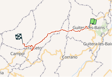
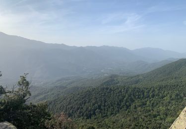
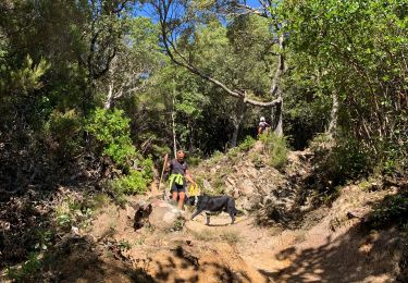
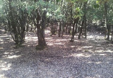
Mare a Mare Centre – de Guitera les Bains à Quasquara L’itinéraire de cette traversée permet la découverte de paysages variés, de régions très typées et authentiques aux villages perchés qui regardent la mer. CInquième étape, de Guitera les Bains à Quasquara. Vous trouverez le descriptif détaillé de cette randonnée dans le Topo-guide «Corse, entre mer et montagne». Pour toute information complémentaire sur la randonnée : Parc Naturel Régional de Corse - 2 rue Sergent Casalonga – BP 417 - 20184 Ajaccio Cedex 1 - Tel : 04 95 50 59 04 Attention les distances et dénivelés indiqués dans le topoguide du Parc restent la référence. Dénivelé : 468 m Dénivelé – : 368 m Département : Corse du sud
Localisation
Commentaires
Randonnées à proximité
![Randonnée Marche Tasso - Tasso Cozzano Guitera Tasso - Photo](https://media.geolcdn.com/t/375/260/d1c44799-5137-4d24-937f-c81851a43f4d.jpg&format=jpg&maxdim=2)
![Marche Marche](https://static1.geolcdn.com/sitytour/trail-icons/101.png)
Marche
![](/images/other/stat-length.png)
![](https://static1.geolcdn.com/siteimages/upload/files/16400158638029165_repeat_loop_refresh_sync_direction_icon.png)
![Randonnée A pied Zicavo - Liaison Zicavo - Refuge de Matalza - Photo](https://media.geolcdn.com/t/375/260/ext.jpg?maxdim=2&url=https%3A%2F%2Fstatic1.geolcdn.com%2Fsiteimages%2Fupload%2Ffiles%2F1545311037marcheuse_200dpi.jpg)
![A pied A pied](https://static1.geolcdn.com/sitytour/trail-icons/100.png)
A pied
![](/images/other/stat-length.png)
![](https://static1.geolcdn.com/siteimages/upload/files/16400158638029165_repeat_loop_refresh_sync_direction_icon.png)
![Randonnée Marche Tasso - Tasso - Col Vizziluga - Photo](https://media.geolcdn.com/t/375/260/b8165558-a788-4210-b0f8-cc7b38ab8b07.jpg&format=jpg&maxdim=2)
![Marche Marche](https://static1.geolcdn.com/sitytour/trail-icons/101.png)
Marche
![](/images/other/stat-length.png)
![](https://static1.geolcdn.com/siteimages/upload/files/16400158638029165_repeat_loop_refresh_sync_direction_icon.png)
![Randonnée Marche Tasso - Punta di Boeing - Photo](https://media.geolcdn.com/t/375/260/884f43a2-6b29-487c-91bf-32e08f43dec8.jpg&format=jpg&maxdim=2)
![Marche Marche](https://static1.geolcdn.com/sitytour/trail-icons/101.png)
![Randonnée Marche Tasso - Tasso - Tasso - Photo](https://media.geolcdn.com/t/375/260/85a77c27-fb25-471c-a960-112f5b664959.jpg&format=jpg&maxdim=2)
![Marche Marche](https://static1.geolcdn.com/sitytour/trail-icons/101.png)
![Randonnée Marche Guitera-les-Bains - 2021/MMC/04 - Notre Mare a mare Centre Etape 04 - Photo](https://media.geolcdn.com/t/375/260/ext.jpg?maxdim=2&url=https%3A%2F%2Fstatic1.geolcdn.com%2Fsiteimages%2Fupload%2Ffiles%2F1553511878bg_sport_marche.png)
![Marche Marche](https://static1.geolcdn.com/sitytour/trail-icons/101.png)
Marche
![](/images/other/stat-length.png)
![](https://static1.geolcdn.com/siteimages/upload/files/16400158638029165_repeat_loop_refresh_sync_direction_icon.png)
![Randonnée Marche Zévaco - 2012-08-18 10h42m15 - Photo](https://media.geolcdn.com/t/375/260/ext.jpg?maxdim=2&url=https%3A%2F%2Fservices.sitytrail.com%2FGeolivesWS%2FDownloadMedia.ashx%3FTrailID%3D147902%26Media%3D20120818101156.jpeg)
![Marche Marche](https://static1.geolcdn.com/sitytour/trail-icons/101.png)
Marche
![](/images/other/stat-length.png)
![](https://static1.geolcdn.com/siteimages/upload/files/16400158638029165_repeat_loop_refresh_sync_direction_icon.png)
![Randonnée sport Guitera-les-Bains - Mar A Mar centre 2024 jour cinq - Photo](https://media.geolcdn.com/t/375/260/ext.jpg?maxdim=2&url=https%3A%2F%2Fsecurestorage.geolives.com%2Fsitytour%2Ftrail-bg%2Fdefault.jpg)
sport
![](/images/other/stat-length.png)
![](https://static1.geolcdn.com/siteimages/upload/files/16400158638029165_repeat_loop_refresh_sync_direction_icon.png)
![Randonnée Marche Zicavo - refuge croci - Photo](https://media.geolcdn.com/t/375/260/ext.jpg?maxdim=2&url=https%3A%2F%2Fstatic1.geolcdn.com%2Fsiteimages%2Fupload%2Ffiles%2F1553511878bg_sport_marche.png)
![Marche Marche](https://static1.geolcdn.com/sitytour/trail-icons/101.png)