![](/images/other/stat-length.png)
![Randonnée Marche Charavines - Pays Voironnais - Circuit GPS de Louisas - La Tour de Clermont Tonnerre - Photo](https://media.geolcdn.com/t/1900/400/ext.pjpeg?maxdim=2&url=https%3A%2F%2Fservices.sitytrail.com%2FGeolivesWS%2FDownloadMedia.ashx%3FTrailID%3D109073%26Media%3D3106_1.jpg)
Pays Voironnais - Circuit GPS de Louisas - La Tour de Clermont Tonnerre
tracegps
Utilisateur
![Longueur](/images/other/stat-length.png)
![Altitude max](https://static1.geolcdn.com/siteimages/upload/files/1508320355ic_sort_altitude_max_24dp.png)
![Dénivelé positif](https://static1.geolcdn.com/siteimages/upload/files/1508320355ic_sort_den_pos_24dp.png)
![Km-Effort](/images/other/stat-length.png)
![Altitude min](https://static1.geolcdn.com/siteimages/upload/files/1508320355ic_sort_altitude_min_24dp.png)
![Dénivelé négatif](https://static1.geolcdn.com/siteimages/upload/files/1508320355ic_sort_den_neg_24dp.png)
![Boucle](https://static1.geolcdn.com/siteimages/upload/files/16400158638029165_repeat_loop_refresh_sync_direction_icon.png)
![Marche](https://static1.geolcdn.com/sitytour/trail-icons/101.png)
2h30
Difficulté : Moyen
![Scannez ce code QR pour ouvrir la randonnée dans l'application SityTrail](https://capi.geolives.com/qq0zvz2zws4bq2lad0pu/sitytour/trails/109073/qr.png?size=200)
Application GPS de randonnée GRATUITE
À propos
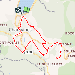
Randonnée Marche de 10 km à découvrir à Auvergne-Rhône-Alpes, Isère, Charavines. Cette randonnée est proposée par tracegps.
Description
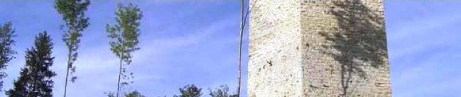
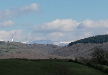
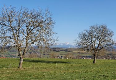
En suivant le chemin, vous arriverez devant un des plus beaux exemples de l’architecture traditionnelle du Pays Voironnais : la Grange de Louisias ensemble en pisé et en chaume remarquable datant de 1605. Pour les plus gourmands possibilité d’achat de fruits rouges, confitures et sirops aux vergers de Louisias (se renseigner sur les horaires). La Tour de Clermont Tonnerre est l’un des points de repère du paysage du tour du lac de Paladru. Remarquable par sa forme pentagonale, le donjon et, avec un élément de courtine, tout ce qui reste du puissant château. A l’intérieur, un pan de grande cheminée en brique situe l’étage résidentiel. Vous ne serez pas déçus par le panorama sur le Lac de Paladru, le Val d’Ainan et la Chartreuse.
Localisation
Commentaires
Randonnées à proximité
![Randonnée V.T.T. Villages du Lac de Paladru - VTT Essai ORBEA court - Photo](https://media.geolcdn.com/t/375/260/ext.jpg?maxdim=2&url=https%3A%2F%2Fstatic1.geolcdn.com%2Fsiteimages%2Fupload%2Ffiles%2F1524743154velo.jpg)
![V.T.T. V.T.T.](https://static1.geolcdn.com/sitytour/trail-icons/202.png)
V.T.T.
![](/images/other/stat-length.png)
![](https://static1.geolcdn.com/siteimages/upload/files/16400158638029165_repeat_loop_refresh_sync_direction_icon.png)
![Randonnée V.T.T. Chirens - Rives Vtt départ Chirens - Photo](https://media.geolcdn.com/t/375/260/ext.jpg?maxdim=2&url=https%3A%2F%2Fstatic1.geolcdn.com%2Fsiteimages%2Fupload%2Ffiles%2F1524743154velo.jpg)
![V.T.T. V.T.T.](https://static1.geolcdn.com/sitytour/trail-icons/202.png)
V.T.T.
![](/images/other/stat-length.png)
![](https://static1.geolcdn.com/siteimages/upload/files/16400158638029165_repeat_loop_refresh_sync_direction_icon.png)
![Randonnée V.T.T. Villages du Lac de Paladru - Saint Geoirs valdaine St Sulpice b - Photo](https://media.geolcdn.com/t/375/260/ext.jpg?maxdim=2&url=https%3A%2F%2Fstatic1.geolcdn.com%2Fsiteimages%2Fupload%2Ffiles%2F1524743154velo.jpg)
![V.T.T. V.T.T.](https://static1.geolcdn.com/sitytour/trail-icons/202.png)
V.T.T.
![](/images/other/stat-length.png)
![](https://static1.geolcdn.com/siteimages/upload/files/16400158638029165_repeat_loop_refresh_sync_direction_icon.png)
![Randonnée Marche Charavines - Lac de Paladru - Photo](https://media.geolcdn.com/t/375/260/ext.jpg?maxdim=2&url=https%3A%2F%2Fstatic1.geolcdn.com%2Fsiteimages%2Fupload%2Ffiles%2F1553511878bg_sport_marche.png)
![Marche Marche](https://static1.geolcdn.com/sitytour/trail-icons/101.png)
Marche
![](/images/other/stat-length.png)
![](https://static1.geolcdn.com/siteimages/upload/files/16400158638029165_repeat_loop_refresh_sync_direction_icon.png)
![Randonnée V.T.T. Montferrat - Essai orbea rise husquvarna - Photo](https://media.geolcdn.com/t/375/260/ext.jpg?maxdim=2&url=https%3A%2F%2Fstatic1.geolcdn.com%2Fsiteimages%2Fupload%2Ffiles%2F1524743154velo.jpg)
![V.T.T. V.T.T.](https://static1.geolcdn.com/sitytour/trail-icons/202.png)
V.T.T.
![](/images/other/stat-length.png)
![](https://static1.geolcdn.com/siteimages/upload/files/16400158638029165_repeat_loop_refresh_sync_direction_icon.png)
![Randonnée Marche Oyeu - blaune 2023 - Photo](https://media.geolcdn.com/t/375/260/e0d52df6-a224-4b53-a2ff-0000526481b4.jpg&format=jpg&maxdim=2)
![Marche Marche](https://static1.geolcdn.com/sitytour/trail-icons/101.png)
Marche
![](/images/other/stat-length.png)
![](https://static1.geolcdn.com/siteimages/upload/files/16400158638029165_repeat_loop_refresh_sync_direction_icon.png)
![Randonnée Marche Charavines - Balade entre Clermont et Charavine - Photo](https://media.geolcdn.com/t/375/260/67a7c968-1766-4645-944f-f3818287cb9d.jpg&format=jpg&maxdim=2)
![Marche Marche](https://static1.geolcdn.com/sitytour/trail-icons/101.png)
Marche
![](/images/other/stat-length.png)
![](https://static1.geolcdn.com/siteimages/upload/files/16400158638029165_repeat_loop_refresh_sync_direction_icon.png)
![Randonnée Marche Villages du Lac de Paladru - Villages du Lac de Paladru - Au dessus du lac - Photo](https://media.geolcdn.com/t/375/260/4c4c3aaf-ee40-4b72-bfa3-d6f5abcd347e.jpg&format=jpg&maxdim=2)
![Marche Marche](https://static1.geolcdn.com/sitytour/trail-icons/101.png)
Marche
![](/images/other/stat-length.png)
![](https://static1.geolcdn.com/siteimages/upload/files/16400158638029165_repeat_loop_refresh_sync_direction_icon.png)
![Randonnée V.T.C. Bilieu - Tour du lac de Paladru - Photo](https://media.geolcdn.com/t/375/260/01f6fa73-f155-4ee5-b90d-cbd26fda1354.jpg&format=jpg&maxdim=2)
![V.T.C. V.T.C.](https://static1.geolcdn.com/sitytour/trail-icons/203.png)
V.T.C.
![](/images/other/stat-length.png)
![](https://static1.geolcdn.com/siteimages/upload/files/16400158638029165_repeat_loop_refresh_sync_direction_icon.png)