![](/images/other/stat-length.png)
![Randonnée Marche La Llagonne - Puig de la Tossa - Photo](https://media.geolcdn.com/t/1900/400/ext.pjpeg?maxdim=2&url=https%3A%2F%2Fservices.sitytrail.com%2FGeolivesWS%2FDownloadMedia.ashx%3FTrailID%3D108946%26Media%3D2808_1.jpg)
Puig de la Tossa
tracegps
Utilisateur
![Longueur](/images/other/stat-length.png)
Longueur
11,7 km
![Altitude max](https://static1.geolcdn.com/siteimages/upload/files/1508320355ic_sort_altitude_max_24dp.png)
Altitude max
2037 m
![Dénivelé positif](https://static1.geolcdn.com/siteimages/upload/files/1508320355ic_sort_den_pos_24dp.png)
Dénivelé positif
451 m
![Km-Effort](/images/other/stat-length.png)
Km-Effort
17,7 km
![Altitude min](https://static1.geolcdn.com/siteimages/upload/files/1508320355ic_sort_altitude_min_24dp.png)
Altitude min
1619 m
![Dénivelé négatif](https://static1.geolcdn.com/siteimages/upload/files/1508320355ic_sort_den_neg_24dp.png)
Dénivelé négatif
449 m
![Boucle](https://static1.geolcdn.com/siteimages/upload/files/16400158638029165_repeat_loop_refresh_sync_direction_icon.png)
Boucle
Oui
Date de création :
2014-12-10 00:00:00.0
Dernière modification :
2014-12-10 00:00:00.0
![Marche](https://static1.geolcdn.com/sitytour/trail-icons/101.png)
5h00
Difficulté : Difficile
![Scannez ce code QR pour ouvrir la randonnée dans l'application SityTrail](https://capi.geolives.com/qq0zvz2zws4bq2lad0pu/sitytour/trails/108946/qr.png?size=200)
Application GPS de randonnée GRATUITE
À propos
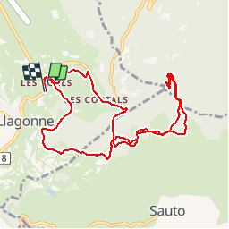
Randonnée Marche de 11,7 km à découvrir à Occitanie, Pyrénées-Orientales, La Llagonne. Cette randonnée est proposée par tracegps.
Description
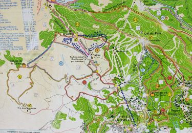
Une randonnée en boucle vers le Puig de la Tossa. D’autres informations et photos sont disponibles ICI Balade proposée par « Les Balades et Randonnées de Fred »
Localisation
Pays :
France
Région :
Occitanie
Département/Province :
Pyrénées-Orientales
Commune :
La Llagonne
Localité :
Unknown
Départ:(Dec)
Départ:(UTM)
428342 ; 4708969 (31T) N.
Commentaires
Randonnées à proximité
![Randonnée Marche Fontpédrouse - Tour du Cucurucull - Photo](https://media.geolcdn.com/t/375/260/ext.jpg?maxdim=2&url=https%3A%2F%2Fservices.sitytrail.com%2FGeolivesWS%2FDownloadMedia.ashx%3FTrailID%3D376769%26Media%3Dfix__20150112140709.jpg)
![Marche Marche](https://static1.geolcdn.com/sitytour/trail-icons/101.png)
Tour du Cucurucull
Marche
Moyen
(1)
Fontpédrouse,
Occitanie,
Pyrénées-Orientales,
France
![](/images/other/stat-length.png)
9,3 km | 18,5 km-effort
3h 24min
![](https://static1.geolcdn.com/siteimages/upload/files/16400158638029165_repeat_loop_refresh_sync_direction_icon.png)
Oui
![Randonnée Marche Planès - étang de Planès - Photo](https://media.geolcdn.com/t/375/260/ext.jpg?maxdim=2&url=https%3A%2F%2Fservices.sitytrail.com%2FGeolivesWS%2FDownloadMedia.ashx%3FTrailID%3D330882%26Media%3Dfix__20140804135744.jpg)
![Marche Marche](https://static1.geolcdn.com/sitytour/trail-icons/101.png)
étang de Planès
Marche
Moyen
(2)
Planès,
Occitanie,
Pyrénées-Orientales,
France
![](/images/other/stat-length.png)
10,8 km | 19,6 km-effort
3h 54min
![](https://static1.geolcdn.com/siteimages/upload/files/16400158638029165_repeat_loop_refresh_sync_direction_icon.png)
Non
![Randonnée Marche Fontpédrouse - fontpérouse sentier des canaux et sources chaudes naturelles_T - Photo](https://media.geolcdn.com/t/375/260/ext.jpg?maxdim=2&url=https%3A%2F%2Fservices.sitytrail.com%2FGeolivesWS%2FDownloadMedia.ashx%3FTrailID%3D327463%26Media%3Dfix__20140724100812.jpg)
![Marche Marche](https://static1.geolcdn.com/sitytour/trail-icons/101.png)
fontpérouse sentier des canaux et sources chaudes naturelles_T
Marche
Moyen
(1)
Fontpédrouse,
Occitanie,
Pyrénées-Orientales,
France
![](/images/other/stat-length.png)
13,7 km | 25 km-effort
5h 9min
![](https://static1.geolcdn.com/siteimages/upload/files/16400158638029165_repeat_loop_refresh_sync_direction_icon.png)
Oui
![Randonnée Marche Bolquère - bolqueres - Photo](https://media.geolcdn.com/t/375/260/0114987c-c8cc-4b45-b859-e4b1075b9834.jpg&format=jpg&maxdim=2)
![Marche Marche](https://static1.geolcdn.com/sitytour/trail-icons/101.png)
bolqueres
Marche
Très facile
(1)
Bolquère,
Occitanie,
Pyrénées-Orientales,
France
![](/images/other/stat-length.png)
3,8 km | 4,6 km-effort
1h 1min
![](https://static1.geolcdn.com/siteimages/upload/files/16400158638029165_repeat_loop_refresh_sync_direction_icon.png)
Oui
![Randonnée Marche La Cabanasse - Mois pontpedrouse après montée en train jaune - Photo](https://media.geolcdn.com/t/375/260/faab2c37-8bf8-419b-a8bb-43eea6c57cc7.jpg&format=jpg&maxdim=2)
![Marche Marche](https://static1.geolcdn.com/sitytour/trail-icons/101.png)
Mois pontpedrouse après montée en train jaune
Marche
Très facile
La Cabanasse,
Occitanie,
Pyrénées-Orientales,
France
![](/images/other/stat-length.png)
9,2 km | 14,3 km-effort
3h 33min
![](https://static1.geolcdn.com/siteimages/upload/files/16400158638029165_repeat_loop_refresh_sync_direction_icon.png)
Non
![Randonnée Marche Saint-Pierre-dels-Forcats - bains de St Thomas - Photo](https://media.geolcdn.com/t/375/260/ext.jpg?maxdim=2&url=https%3A%2F%2Fstatic1.geolcdn.com%2Fsiteimages%2Fupload%2Ffiles%2F1553511878bg_sport_marche.png)
![Marche Marche](https://static1.geolcdn.com/sitytour/trail-icons/101.png)
bains de St Thomas
Marche
Moyen
(1)
Saint-Pierre-dels-Forcats,
Occitanie,
Pyrénées-Orientales,
France
![](/images/other/stat-length.png)
8,6 km | 12,2 km-effort
2h 42min
![](https://static1.geolcdn.com/siteimages/upload/files/16400158638029165_repeat_loop_refresh_sync_direction_icon.png)
Non
![Randonnée Marche La Llagonne - llagonne - Calvet - Photo](https://media.geolcdn.com/t/375/260/ext.jpg?maxdim=2&url=https%3A%2F%2Fstatic1.geolcdn.com%2Fsiteimages%2Fupload%2Ffiles%2F1553511878bg_sport_marche.png)
![Marche Marche](https://static1.geolcdn.com/sitytour/trail-icons/101.png)
llagonne - Calvet
Marche
Moyen
(2)
La Llagonne,
Occitanie,
Pyrénées-Orientales,
France
![](/images/other/stat-length.png)
11,2 km | 14,2 km-effort
3h 0min
![](https://static1.geolcdn.com/siteimages/upload/files/16400158638029165_repeat_loop_refresh_sync_direction_icon.png)
Non
![Randonnée Marche Les Angles - boucle de la Balmette par le mont Llaret et le roc d'aude - Photo](https://media.geolcdn.com/t/375/260/ext.jpg?maxdim=2&url=https%3A%2F%2Fstatic1.geolcdn.com%2Fsiteimages%2Fupload%2Ffiles%2F1553511878bg_sport_marche.png)
![Marche Marche](https://static1.geolcdn.com/sitytour/trail-icons/101.png)
boucle de la Balmette par le mont Llaret et le roc d'aude
Marche
Moyen
(2)
Les Angles,
Occitanie,
Pyrénées-Orientales,
France
![](/images/other/stat-length.png)
17,2 km | 28 km-effort
Inconnu
![](https://static1.geolcdn.com/siteimages/upload/files/16400158638029165_repeat_loop_refresh_sync_direction_icon.png)
Oui
![Randonnée Marche La Cabanasse - train jaune 01 - Photo](https://media.geolcdn.com/t/375/260/089f6d29-ecf8-4421-b837-b8b1a2c0c8be.jpg&format=jpg&maxdim=2)
![Marche Marche](https://static1.geolcdn.com/sitytour/trail-icons/101.png)
train jaune 01
Marche
Difficile
La Cabanasse,
Occitanie,
Pyrénées-Orientales,
France
![](/images/other/stat-length.png)
11,1 km | 15,1 km-effort
5h 3min
![](https://static1.geolcdn.com/siteimages/upload/files/16400158638029165_repeat_loop_refresh_sync_direction_icon.png)
Non