![](/images/other/stat-length.png)
![Randonnée Marche Thiepval - Autour du mémorial de Thiepval - Photo](https://media.geolcdn.com/t/1900/400/ext.pjpeg?maxdim=2&url=https%3A%2F%2Fservices.sitytrail.com%2FGeolivesWS%2FDownloadMedia.ashx%3FTrailID%3D108848%26Media%3D2392_2.jpg)
Autour du mémorial de Thiepval
tracegps
Utilisateur
![Longueur](/images/other/stat-length.png)
Longueur
14,1 km
![Altitude max](https://static1.geolcdn.com/siteimages/upload/files/1508320355ic_sort_altitude_max_24dp.png)
Altitude max
149 m
![Dénivelé positif](https://static1.geolcdn.com/siteimages/upload/files/1508320355ic_sort_den_pos_24dp.png)
Dénivelé positif
209 m
![Km-Effort](/images/other/stat-length.png)
Km-Effort
16,9 km
![Altitude min](https://static1.geolcdn.com/siteimages/upload/files/1508320355ic_sort_altitude_min_24dp.png)
Altitude min
69 m
![Dénivelé négatif](https://static1.geolcdn.com/siteimages/upload/files/1508320355ic_sort_den_neg_24dp.png)
Dénivelé négatif
209 m
![Boucle](https://static1.geolcdn.com/siteimages/upload/files/16400158638029165_repeat_loop_refresh_sync_direction_icon.png)
Boucle
Oui
Date de création :
2014-12-10 00:00:00.0
Dernière modification :
2014-12-10 00:00:00.0
![Marche](https://static1.geolcdn.com/sitytour/trail-icons/101.png)
4h30
Difficulté : Difficile
![Scannez ce code QR pour ouvrir la randonnée dans l'application SityTrail](https://capi.geolives.com/qq0zvz2zws4bq2lad0pu/sitytour/trails/108848/qr.png?size=200)
Application GPS de randonnée GRATUITE
À propos
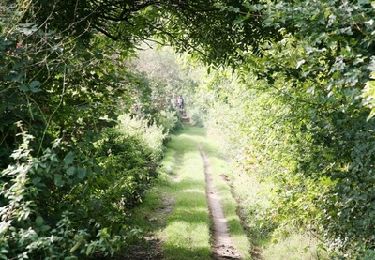
Randonnée Marche de 14,1 km à découvrir à Hauts-de-France, Somme, Thiepval. Cette randonnée est proposée par tracegps.
Description
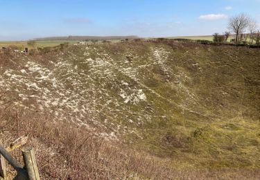
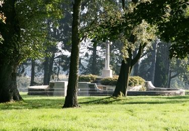
Paisible aujourd'hui, ce coin de terre picarde est devenu une étape incontournable du Circuit du Souvenir. Pour télécharger la fiche du circuit en format pdf.
Localisation
Pays :
France
Région :
Hauts-de-France
Département/Province :
Somme
Commune :
Thiepval
Localité :
Unknown
Départ:(Dec)
Départ:(UTM)
477716 ; 5544474 (31U) N.
Commentaires
Randonnées à proximité
![Randonnée Marche Thiepval - thiepval - Photo](https://media.geolcdn.com/t/375/260/ext.jpg?maxdim=2&url=https%3A%2F%2Fstatic1.geolcdn.com%2Fsiteimages%2Fupload%2Ffiles%2F1553511878bg_sport_marche.png)
![Marche Marche](https://static1.geolcdn.com/sitytour/trail-icons/101.png)
thiepval
Marche
Difficile
(1)
Thiepval,
Hauts-de-France,
Somme,
France
![](/images/other/stat-length.png)
14,5 km | 17,3 km-effort
2h 7min
![](https://static1.geolcdn.com/siteimages/upload/files/16400158638029165_repeat_loop_refresh_sync_direction_icon.png)
Oui
![Randonnée Marche Ovillers-la-Boisselle - La Boissellerie - Photo](https://media.geolcdn.com/t/375/260/9d3a626c-3914-4a11-9643-13abb3fa822f.jpg&format=jpg&maxdim=2)
![Marche Marche](https://static1.geolcdn.com/sitytour/trail-icons/101.png)
La Boissellerie
Marche
Moyen
Ovillers-la-Boisselle,
Hauts-de-France,
Somme,
France
![](/images/other/stat-length.png)
18,4 km | 21 km-effort
4h 22min
![](https://static1.geolcdn.com/siteimages/upload/files/16400158638029165_repeat_loop_refresh_sync_direction_icon.png)
Oui
![Randonnée Marche Thiepval - Autour du mémorial de Thiepval (variante courte) - Photo](https://media.geolcdn.com/t/375/260/ext.jpg?maxdim=2&url=https%3A%2F%2Fservices.sitytrail.com%2FGeolivesWS%2FDownloadMedia.ashx%3FTrailID%3D108874%26Media%3D2418_1.jpg)
![Marche Marche](https://static1.geolcdn.com/sitytour/trail-icons/101.png)
Autour du mémorial de Thiepval (variante courte)
Marche
Moyen
Thiepval,
Hauts-de-France,
Somme,
France
![](/images/other/stat-length.png)
7,6 km | 9,2 km-effort
2h 30min
![](https://static1.geolcdn.com/siteimages/upload/files/16400158638029165_repeat_loop_refresh_sync_direction_icon.png)
Oui
![Randonnée Marche Auchonvillers - Circuit du Caribou - Photo](https://media.geolcdn.com/t/375/260/ext.jpg?maxdim=2&url=https%3A%2F%2Fservices.sitytrail.com%2FGeolivesWS%2FDownloadMedia.ashx%3FTrailID%3D108847%26Media%3D2391_2.jpg)
![Marche Marche](https://static1.geolcdn.com/sitytour/trail-icons/101.png)
Circuit du Caribou
Marche
Moyen
Auchonvillers,
Hauts-de-France,
Somme,
France
![](/images/other/stat-length.png)
8,4 km | 9,6 km-effort
2h 40min
![](https://static1.geolcdn.com/siteimages/upload/files/16400158638029165_repeat_loop_refresh_sync_direction_icon.png)
Oui
![Randonnée A pied Thiepval - thiepval 14 KM - Photo](https://media.geolcdn.com/t/375/260/ext.jpg?maxdim=2&url=https%3A%2F%2Fstatic1.geolcdn.com%2Fsiteimages%2Fupload%2Ffiles%2F1545311037marcheuse_200dpi.jpg)
![A pied A pied](https://static1.geolcdn.com/sitytour/trail-icons/100.png)
thiepval 14 KM
A pied
Facile
Thiepval,
Hauts-de-France,
Somme,
France
![](/images/other/stat-length.png)
13,8 km | 16,6 km-effort
3h 46min
![](https://static1.geolcdn.com/siteimages/upload/files/16400158638029165_repeat_loop_refresh_sync_direction_icon.png)
Oui
![Randonnée V.T.C. Albert - Albert Péronne - Photo](https://media.geolcdn.com/t/375/260/ext.jpg?maxdim=2&url=https%3A%2F%2Fstatic1.geolcdn.com%2Fsiteimages%2Fupload%2Ffiles%2F1524743154velo.jpg)
![V.T.C. V.T.C.](https://static1.geolcdn.com/sitytour/trail-icons/203.png)
Albert Péronne
V.T.C.
Très facile
Albert,
Hauts-de-France,
Somme,
France
![](/images/other/stat-length.png)
39 km | 45 km-effort
3h 1min
![](https://static1.geolcdn.com/siteimages/upload/files/16400158638029165_repeat_loop_refresh_sync_direction_icon.png)
Non
![Randonnée V.T.C. Albert - Boucle d Albert - Photo](https://media.geolcdn.com/t/375/260/ext.jpg?maxdim=2&url=https%3A%2F%2Fstatic1.geolcdn.com%2Fsiteimages%2Fupload%2Ffiles%2F1524743154velo.jpg)
![V.T.C. V.T.C.](https://static1.geolcdn.com/sitytour/trail-icons/203.png)
Boucle d Albert
V.T.C.
Très facile
Albert,
Hauts-de-France,
Somme,
France
![](/images/other/stat-length.png)
33 km | 38 km-effort
2h 38min
![](https://static1.geolcdn.com/siteimages/upload/files/16400158638029165_repeat_loop_refresh_sync_direction_icon.png)
Oui
![Randonnée Cyclotourisme Albert - GG Albert Corbie - Photo](https://media.geolcdn.com/t/375/260/ext.jpg?maxdim=2&url=https%3A%2F%2Fstatic1.geolcdn.com%2Fsiteimages%2Fupload%2Ffiles%2F1524743154velo.jpg)
![Cyclotourisme Cyclotourisme](https://static1.geolcdn.com/sitytour/trail-icons/204.png)
GG Albert Corbie
Cyclotourisme
Moyen
Albert,
Hauts-de-France,
Somme,
France
![](/images/other/stat-length.png)
23 km | 26 km-effort
1h 46min
![](https://static1.geolcdn.com/siteimages/upload/files/16400158638029165_repeat_loop_refresh_sync_direction_icon.png)
Non