![](/images/other/stat-length.png)
![Randonnée Marche Pradelles-Cabardès - Le Pic de Nore - Photo](https://media.geolcdn.com/t/1900/400/ext.pjpeg?maxdim=2&url=https%3A%2F%2Fservices.sitytrail.com%2FGeolivesWS%2FDownloadMedia.ashx%3FTrailID%3D108805%26Media%3D2126_6.jpg)
Le Pic de Nore
tracegps
Utilisateur
![Longueur](/images/other/stat-length.png)
Longueur
13,5 km
![Altitude max](https://static1.geolcdn.com/siteimages/upload/files/1508320355ic_sort_altitude_max_24dp.png)
Altitude max
1214 m
![Dénivelé positif](https://static1.geolcdn.com/siteimages/upload/files/1508320355ic_sort_den_pos_24dp.png)
Dénivelé positif
537 m
![Km-Effort](/images/other/stat-length.png)
Km-Effort
21 km
![Altitude min](https://static1.geolcdn.com/siteimages/upload/files/1508320355ic_sort_altitude_min_24dp.png)
Altitude min
771 m
![Dénivelé négatif](https://static1.geolcdn.com/siteimages/upload/files/1508320355ic_sort_den_neg_24dp.png)
Dénivelé négatif
534 m
![Boucle](https://static1.geolcdn.com/siteimages/upload/files/16400158638029165_repeat_loop_refresh_sync_direction_icon.png)
Boucle
Oui
Date de création :
2014-12-10 00:00:00.0
Dernière modification :
2014-12-10 00:00:00.0
![Marche](https://static1.geolcdn.com/sitytour/trail-icons/101.png)
5h45
Difficulté : Difficile
![Scannez ce code QR pour ouvrir la randonnée dans l'application SityTrail](https://capi.geolives.com/qq0zvz2zws4bq2lad0pu/sitytour/trails/108805/qr.png?size=200)
Application GPS de randonnée GRATUITE
À propos
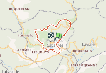
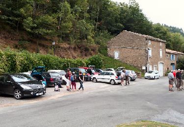
Randonnée Marche de 13,5 km à découvrir à Occitanie, Aude, Pradelles-Cabardès. Cette randonnée est proposée par tracegps.
Description
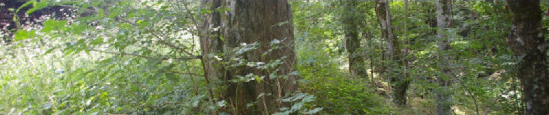
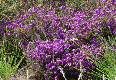
Une boucle depuis Pradelles - Cabardès en passant par le Roquo d'Astié, le Pic de Nore et le Roc du Nouret. De jolis paysages sur la Montagne Noire, des anciennes glacières près du village et une pierre levée.
Localisation
Pays :
France
Région :
Occitanie
Département/Province :
Aude
Commune :
Pradelles-Cabardès
Localité :
Unknown
Départ:(Dec)
Départ:(UTM)
455122 ; 4806323 (31T) N.
Commentaires
Randonnées à proximité
![Randonnée Marche Castans - Boucle des ruisseaux - Castans - Photo](https://media.geolcdn.com/t/375/260/ext.jpg?maxdim=2&url=https%3A%2F%2Fservices.sitytrail.com%2FGeolivesWS%2FDownloadMedia.ashx%3FTrailID%3D107218%26Media%3D12083_6.jpg)
![Marche Marche](https://static1.geolcdn.com/sitytour/trail-icons/101.png)
Boucle des ruisseaux - Castans
Marche
Moyen
(5)
Castans,
Occitanie,
Aude,
France
![](/images/other/stat-length.png)
6,4 km | 10 km-effort
4h 0min
![](https://static1.geolcdn.com/siteimages/upload/files/16400158638029165_repeat_loop_refresh_sync_direction_icon.png)
Oui
![Randonnée A pied Pradelles-Cabardès - Les Villages Perchés - Photo](https://media.geolcdn.com/t/375/260/ext.jpg?maxdim=2&url=https%3A%2F%2Fmedia.geolcdn.com%2Ff%2Fe752b52d-77fb-4704-ae95-b1e1dc6afb9d.jpeg)
![A pied A pied](https://static1.geolcdn.com/sitytour/trail-icons/100.png)
Les Villages Perchés
A pied
Moyen
Pradelles-Cabardès,
Occitanie,
Aude,
France
![](/images/other/stat-length.png)
19,4 km | 29 km-effort
6h 34min
![](https://static1.geolcdn.com/siteimages/upload/files/16400158638029165_repeat_loop_refresh_sync_direction_icon.png)
Non
![Randonnée A pied Labastide-Esparbaïrenque - Les Villages Perchés - Photo](https://media.geolcdn.com/t/375/260/ext.jpg?maxdim=2&url=https%3A%2F%2Fmedia.geolcdn.com%2Ff%2F87afa764-5c51-4a79-b394-b4027bc6ab46.jpeg)
![A pied A pied](https://static1.geolcdn.com/sitytour/trail-icons/100.png)
Les Villages Perchés
A pied
Difficile
Labastide-Esparbaïrenque,
Occitanie,
Aude,
France
![](/images/other/stat-length.png)
24 km | 38 km-effort
8h 32min
![](https://static1.geolcdn.com/siteimages/upload/files/16400158638029165_repeat_loop_refresh_sync_direction_icon.png)
Oui
![Randonnée A pied Pradelles-Cabardès - Les Villages Perchés - Photo](https://media.geolcdn.com/t/375/260/ext.jpg?maxdim=2&url=https%3A%2F%2Fmedia.geolcdn.com%2Ff%2Fdb649366-1098-4fbe-adda-fceac6e0e268.jpeg)
![A pied A pied](https://static1.geolcdn.com/sitytour/trail-icons/100.png)
Les Villages Perchés
A pied
Moyen
Pradelles-Cabardès,
Occitanie,
Aude,
France
![](/images/other/stat-length.png)
19,2 km | 26 km-effort
5h 53min
![](https://static1.geolcdn.com/siteimages/upload/files/16400158638029165_repeat_loop_refresh_sync_direction_icon.png)
Non
![Randonnée A pied Pradelles-Cabardès - Pradelles Cabardes . Le Pic de Nore, le sentier du Roc Nouret. - Photo](https://media.geolcdn.com/t/375/260/ext.jpg?maxdim=2&url=https%3A%2F%2Fstatic1.geolcdn.com%2Fsiteimages%2Fupload%2Ffiles%2F1545311037marcheuse_200dpi.jpg)
![A pied A pied](https://static1.geolcdn.com/sitytour/trail-icons/100.png)
Pradelles Cabardes . Le Pic de Nore, le sentier du Roc Nouret.
A pied
Facile
(1)
Pradelles-Cabardès,
Occitanie,
Aude,
France
![](/images/other/stat-length.png)
10,4 km | 16,4 km-effort
3h 44min
![](https://static1.geolcdn.com/siteimages/upload/files/16400158638029165_repeat_loop_refresh_sync_direction_icon.png)
Oui
![Randonnée A pied Roquefère - Labastide-Espabïrenque, Prat Viel, Picarot haut - Photo](https://media.geolcdn.com/t/375/260/ext.jpg?maxdim=2&url=https%3A%2F%2Fstatic1.geolcdn.com%2Fsiteimages%2Fupload%2Ffiles%2F1545311037marcheuse_200dpi.jpg)
![A pied A pied](https://static1.geolcdn.com/sitytour/trail-icons/100.png)
Labastide-Espabïrenque, Prat Viel, Picarot haut
A pied
Moyen
(1)
Roquefère,
Occitanie,
Aude,
France
![](/images/other/stat-length.png)
10,2 km | 15,6 km-effort
3h 0min
![](https://static1.geolcdn.com/siteimages/upload/files/16400158638029165_repeat_loop_refresh_sync_direction_icon.png)
Oui
![Randonnée A pied Roquefère - Les Villages Perchés - Photo](https://media.geolcdn.com/t/375/260/ext.jpg?maxdim=2&url=https%3A%2F%2Fmedia.geolcdn.com%2Ff%2F56efaba7-8d40-4104-864f-2d6b350d402b.jpeg)
![A pied A pied](https://static1.geolcdn.com/sitytour/trail-icons/100.png)
Les Villages Perchés
A pied
Facile
Roquefère,
Occitanie,
Aude,
France
![](/images/other/stat-length.png)
6,8 km | 11,7 km-effort
2h 40min
![](https://static1.geolcdn.com/siteimages/upload/files/16400158638029165_repeat_loop_refresh_sync_direction_icon.png)
Non
![Randonnée A pied Pradelles-Cabardès - Pradelles,roc de l'aigle,cabrespine,pradelles - Photo](https://media.geolcdn.com/t/375/260/ext.jpg?maxdim=2&url=https%3A%2F%2Fmedia.geolcdn.com%2Ff%2F82fe34a8-bde4-49e0-8e94-332d7cbba6cc.jpg)
![A pied A pied](https://static1.geolcdn.com/sitytour/trail-icons/100.png)
Pradelles,roc de l'aigle,cabrespine,pradelles
A pied
Difficile
Pradelles-Cabardès,
Occitanie,
Aude,
France
![](/images/other/stat-length.png)
15,3 km | 24 km-effort
5h 50min
![](https://static1.geolcdn.com/siteimages/upload/files/16400158638029165_repeat_loop_refresh_sync_direction_icon.png)
Oui
![Randonnée Marche Roquefère - De pic en pas et de col en val - Labastide Esparbairenque - Photo](https://media.geolcdn.com/t/375/260/ext.jpg?maxdim=2&url=https%3A%2F%2Fservices.sitytrail.com%2FGeolivesWS%2FDownloadMedia.ashx%3FTrailID%3D172842%26Media%3D14284_5.jpg)
![Marche Marche](https://static1.geolcdn.com/sitytour/trail-icons/101.png)
De pic en pas et de col en val - Labastide Esparbairenque
Marche
Moyen
Roquefère,
Occitanie,
Aude,
France
![](/images/other/stat-length.png)
23 km | 33 km-effort
7h 0min
![](https://static1.geolcdn.com/siteimages/upload/files/16400158638029165_repeat_loop_refresh_sync_direction_icon.png)
Oui