![](/images/other/stat-length.png)
![Randonnée Marche Ouhans - Le Mont Pelé (1045 m) - Jura - Photo](https://media.geolcdn.com/t/1900/400/ext.pjpeg?maxdim=2&url=https%3A%2F%2Fservices.sitytrail.com%2FGeolivesWS%2FDownloadMedia.ashx%3FTrailID%3D108776%26Media%3D1918_2.jpg)
Le Mont Pelé (1045 m) - Jura
tracegps
Utilisateur
![Longueur](/images/other/stat-length.png)
![Altitude max](https://static1.geolcdn.com/siteimages/upload/files/1508320355ic_sort_altitude_max_24dp.png)
![Dénivelé positif](https://static1.geolcdn.com/siteimages/upload/files/1508320355ic_sort_den_pos_24dp.png)
![Km-Effort](/images/other/stat-length.png)
![Altitude min](https://static1.geolcdn.com/siteimages/upload/files/1508320355ic_sort_altitude_min_24dp.png)
![Dénivelé négatif](https://static1.geolcdn.com/siteimages/upload/files/1508320355ic_sort_den_neg_24dp.png)
![Boucle](https://static1.geolcdn.com/siteimages/upload/files/16400158638029165_repeat_loop_refresh_sync_direction_icon.png)
![Marche](https://static1.geolcdn.com/sitytour/trail-icons/101.png)
2h00
Difficulté : Facile
![Scannez ce code QR pour ouvrir la randonnée dans l'application SityTrail](https://capi.geolives.com/qq0zvz2zws4bq2lad0pu/sitytour/trails/108776/qr.png?size=200)
Application GPS de randonnée GRATUITE
À propos
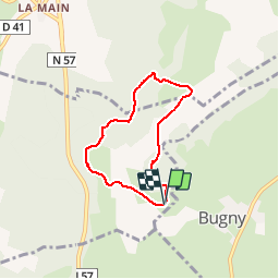
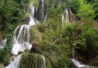
Randonnée Marche de 5,6 km à découvrir à Bourgogne-Franche-Comté, Doubs, Ouhans. Cette randonnée est proposée par tracegps.
Description
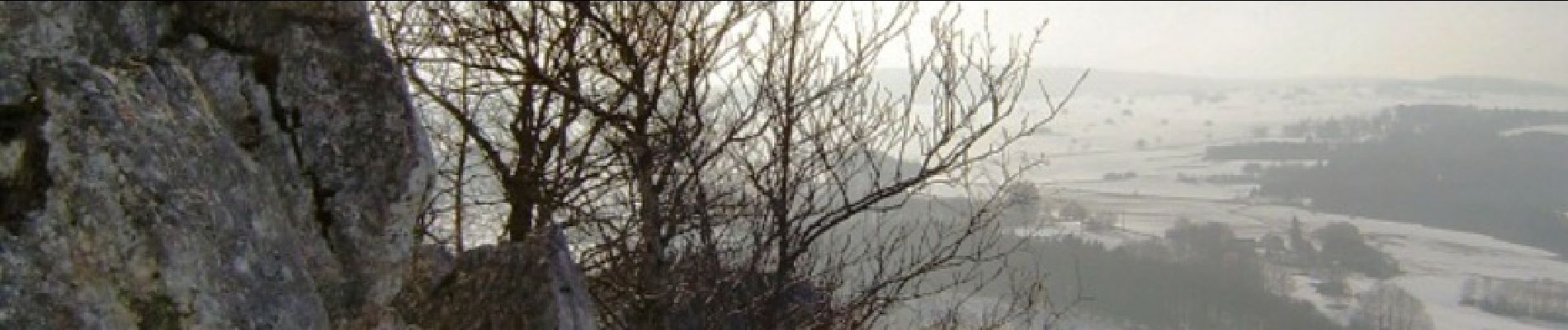
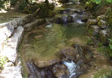
Cette charmante randonnée permet de gravir le Mont Pelé (1045 m), sommet le plus à l'ouest de l'anticlinal du Crêt Monniot. Même si la vue au sommet est un peu moins étendue que celle de son grand frère, elle reste très dégagée en particulier sur la Haute-Vallée de la Loue et le Val des Usiers en contrebas, mais aussi sur la Haute-Chaîne du Jura. La suite avec d’autres informations et photos est ICI
Localisation
Commentaires
Randonnées à proximité
![Randonnée Marche Mouthier-Haute-Pierre - gorges de noailles - Photo](https://media.geolcdn.com/t/375/260/f0988f40-3a38-4970-931c-be04fc88ebef.jpg&format=jpg&maxdim=2)
![Marche Marche](https://static1.geolcdn.com/sitytour/trail-icons/101.png)
Marche
![](/images/other/stat-length.png)
![](https://static1.geolcdn.com/siteimages/upload/files/16400158638029165_repeat_loop_refresh_sync_direction_icon.png)
![Randonnée Marche Ouhans - la source de la loue - Photo](https://media.geolcdn.com/t/375/260/ext.jpg?maxdim=2&url=https%3A%2F%2Fservices.sitytrail.com%2FGeolivesWS%2FDownloadMedia.ashx%3FTrailID%3D190706%26Media%3D20130510152354.jpeg)
![Marche Marche](https://static1.geolcdn.com/sitytour/trail-icons/101.png)
Marche
![](/images/other/stat-length.png)
![](https://static1.geolcdn.com/siteimages/upload/files/16400158638029165_repeat_loop_refresh_sync_direction_icon.png)
![Randonnée Marche Mouthier-Haute-Pierre - Source de la Loue - Mouthier Haute Pierre - Photo](https://media.geolcdn.com/t/375/260/ext.jpg?maxdim=2&url=https%3A%2F%2Fservices.sitytrail.com%2FGeolivesWS%2FDownloadMedia.ashx%3FTrailID%3D129850%26Media%3D13405_4.jpg)
![Marche Marche](https://static1.geolcdn.com/sitytour/trail-icons/101.png)
Marche
![](/images/other/stat-length.png)
![](https://static1.geolcdn.com/siteimages/upload/files/16400158638029165_repeat_loop_refresh_sync_direction_icon.png)
![Randonnée Marche Mouthier-Haute-Pierre - Gorges de Nouailles - Source de la Loue - Photo](https://media.geolcdn.com/t/375/260/1e011831-b1ba-44f5-a6f9-22ef92de1f5b.jpg&format=jpg&maxdim=2)
![Marche Marche](https://static1.geolcdn.com/sitytour/trail-icons/101.png)
Marche
![](/images/other/stat-length.png)
![](https://static1.geolcdn.com/siteimages/upload/files/16400158638029165_repeat_loop_refresh_sync_direction_icon.png)
![Randonnée Marche Ouhans - boucle de la source de la loue - Photo](https://media.geolcdn.com/t/375/260/8f0df0a7-8115-4a5a-a89e-2e052f220f0c.jpg&format=jpg&maxdim=2)
![Marche Marche](https://static1.geolcdn.com/sitytour/trail-icons/101.png)
Marche
![](/images/other/stat-length.png)
![](https://static1.geolcdn.com/siteimages/upload/files/16400158638029165_repeat_loop_refresh_sync_direction_icon.png)
![Randonnée Marche Mouthier-Haute-Pierre - les gorges de Nouailles - Photo](https://media.geolcdn.com/t/375/260/04c063ce-8736-416a-89db-2859cb57e5d1.jpg&format=jpg&maxdim=2)
![Marche Marche](https://static1.geolcdn.com/sitytour/trail-icons/101.png)
Marche
![](/images/other/stat-length.png)
![](https://static1.geolcdn.com/siteimages/upload/files/16400158638029165_repeat_loop_refresh_sync_direction_icon.png)
![Randonnée Marche Ouhans - la bballade de la loue - Photo](https://media.geolcdn.com/t/375/260/ext.jpg?maxdim=2&url=https%3A%2F%2Fservices.sitytrail.com%2FGeolivesWS%2FDownloadMedia.ashx%3FTrailID%3D190707%26Media%3D20130510115312.jpeg)
![Marche Marche](https://static1.geolcdn.com/sitytour/trail-icons/101.png)
Marche
![](/images/other/stat-length.png)
![](https://static1.geolcdn.com/siteimages/upload/files/16400158638029165_repeat_loop_refresh_sync_direction_icon.png)
![Randonnée Marche Ouhans - RANDONNEE A LA SOURCE DE LA LOUE - Photo](https://media.geolcdn.com/t/375/260/52ce6abf-4e4a-4f7c-8b3e-3010c4c77c64.jpg&format=jpg&maxdim=2)
![Marche Marche](https://static1.geolcdn.com/sitytour/trail-icons/101.png)
Marche
![](/images/other/stat-length.png)
![](https://static1.geolcdn.com/siteimages/upload/files/16400158638029165_repeat_loop_refresh_sync_direction_icon.png)
![Randonnée Marche Mouthier-Haute-Pierre - Moutier Hautepierre - Photo](https://media.geolcdn.com/t/375/260/40642c9d-ef19-4ac2-9727-9611af2dc752.jpg&format=jpg&maxdim=2)
![Marche Marche](https://static1.geolcdn.com/sitytour/trail-icons/101.png)
Marche
![](/images/other/stat-length.png)
![](https://static1.geolcdn.com/siteimages/upload/files/16400158638029165_repeat_loop_refresh_sync_direction_icon.png)