![](/images/other/stat-length.png)
![Randonnée Marche Saint-Geniez - 20181218_St Geniez_Le Trainon - Photo](https://media.geolcdn.com/t/1900/400/ext.pjpeg?maxdim=2&url=https%3A%2F%2Fservices.sitytrail.com%2FGeolivesWS%2FDownloadMedia.ashx%3FTrailID%3D1085897%26Media%3Dfix__20181218122150.jpg)
20181218_St Geniez_Le Trainon
PapouBertrand
Utilisateur
![Longueur](/images/other/stat-length.png)
Longueur
12,3 km
![Altitude max](https://static1.geolcdn.com/siteimages/upload/files/1508320355ic_sort_altitude_max_24dp.png)
Altitude max
1636 m
![Dénivelé positif](https://static1.geolcdn.com/siteimages/upload/files/1508320355ic_sort_den_pos_24dp.png)
Dénivelé positif
642 m
![Km-Effort](/images/other/stat-length.png)
Km-Effort
21 km
![Altitude min](https://static1.geolcdn.com/siteimages/upload/files/1508320355ic_sort_altitude_min_24dp.png)
Altitude min
1117 m
![Dénivelé négatif](https://static1.geolcdn.com/siteimages/upload/files/1508320355ic_sort_den_neg_24dp.png)
Dénivelé négatif
639 m
![Boucle](https://static1.geolcdn.com/siteimages/upload/files/16400158638029165_repeat_loop_refresh_sync_direction_icon.png)
Boucle
Oui
Date de création :
2019-01-15 19:57:10.399
Dernière modification :
2019-12-06 17:42:36.362
![Marche](https://static1.geolcdn.com/sitytour/trail-icons/101.png)
4h15
Difficulté : Moyen
![Scannez ce code QR pour ouvrir la randonnée dans l'application SityTrail](https://capi.geolives.com/qq0zvz2zws4bq2lad0pu/sitytour/trails/1085897/qr.png?size=200)
Application GPS de randonnée GRATUITE
À propos
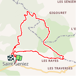
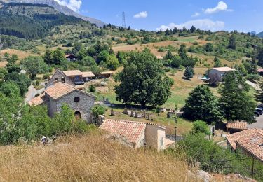
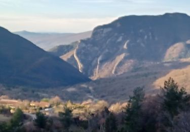
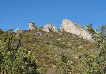
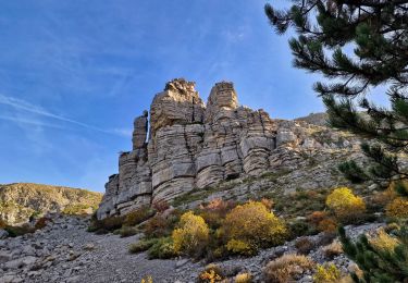
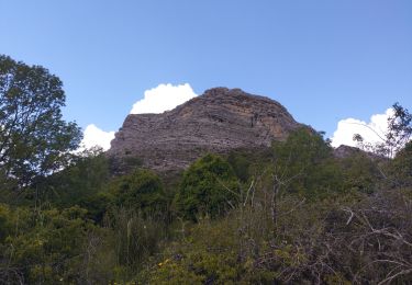
Randonnée Marche de 12,3 km à découvrir à Provence-Alpes-Côte d'Azur, Alpes-de-Haute-Provence, Saint-Geniez. Cette randonnée est proposée par PapouBertrand.
Description
Randonnée du CSA Gap, Marche de 12 km et 650 mètres de dénivelé à découvrir à SAINT-GENIEZ, ALPES-DE-HAUTE-PROVENCE.
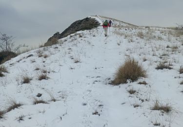
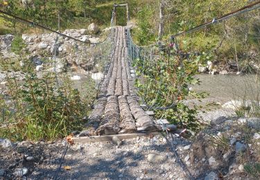
Randonnée sans difficulté avec de très beaux panoramas.
Localisation
Pays :
France
Région :
Provence-Alpes-Côte d'Azur
Département/Province :
Alpes-de-Haute-Provence
Commune :
Saint-Geniez
Localité :
Unknown
Départ:(Dec)
Départ:(UTM)
264672 ; 4903311 (32T) N.
Commentaires
Randonnées à proximité
![Randonnée Marche Saint-Geniez - Le Trainon - Photo](https://media.geolcdn.com/t/375/260/6384f902-eeea-4c31-bc21-4fe490321a44.jpg&format=jpg&maxdim=2)
![Marche Marche](https://static1.geolcdn.com/sitytour/trail-icons/101.png)
Le Trainon
Marche
Moyen
(1)
Saint-Geniez,
Provence-Alpes-Côte d'Azur,
Alpes-de-Haute-Provence,
France
![](/images/other/stat-length.png)
9,8 km | 17,3 km-effort
3h 56min
![](https://static1.geolcdn.com/siteimages/upload/files/16400158638029165_repeat_loop_refresh_sync_direction_icon.png)
Oui
![Randonnée Marche Saint-Geniez - S GENIEZ . ABROS . LA FOREST . COL DE MOUNIS . O L M - Photo](https://media.geolcdn.com/t/375/260/fe9f057e-508d-4bc4-89fa-aff1c37055dd.jpg&format=jpg&maxdim=2)
![Marche Marche](https://static1.geolcdn.com/sitytour/trail-icons/101.png)
S GENIEZ . ABROS . LA FOREST . COL DE MOUNIS . O L M
Marche
Difficile
(1)
Saint-Geniez,
Provence-Alpes-Côte d'Azur,
Alpes-de-Haute-Provence,
France
![](/images/other/stat-length.png)
12,5 km | 20 km-effort
4h 33min
![](https://static1.geolcdn.com/siteimages/upload/files/16400158638029165_repeat_loop_refresh_sync_direction_icon.png)
Oui
![Randonnée Marche Valavoire - Sommet de Jouère - Photo](https://media.geolcdn.com/t/375/260/d8443deb-7a4b-44b3-ac6b-fcb5789c326f.jpg&format=jpg&maxdim=2)
![Marche Marche](https://static1.geolcdn.com/sitytour/trail-icons/101.png)
Sommet de Jouère
Marche
Difficile
Valavoire,
Provence-Alpes-Côte d'Azur,
Alpes-de-Haute-Provence,
France
![](/images/other/stat-length.png)
10,9 km | 21 km-effort
4h 39min
![](https://static1.geolcdn.com/siteimages/upload/files/16400158638029165_repeat_loop_refresh_sync_direction_icon.png)
Oui
![Randonnée Marche Saint-Geniez - Pierre écrite et montagne de Gache - Photo](https://media.geolcdn.com/t/375/260/7a1ca822-6c04-425e-94b9-5be1080d03a0.jpg&format=jpg&maxdim=2)
![Marche Marche](https://static1.geolcdn.com/sitytour/trail-icons/101.png)
Pierre écrite et montagne de Gache
Marche
Facile
Saint-Geniez,
Provence-Alpes-Côte d'Azur,
Alpes-de-Haute-Provence,
France
![](/images/other/stat-length.png)
7,4 km | 12,3 km-effort
2h 38min
![](https://static1.geolcdn.com/siteimages/upload/files/16400158638029165_repeat_loop_refresh_sync_direction_icon.png)
Oui
![Randonnée Marche Entrepierres - SAINT GENIEZ . LE MOURRE DE GACHE PAR LA FONT DE MEGE N - Photo](https://media.geolcdn.com/t/375/260/5d853fdd-5713-4858-a535-57b1bf5db08d.jpg&format=jpg&maxdim=2)
![Marche Marche](https://static1.geolcdn.com/sitytour/trail-icons/101.png)
SAINT GENIEZ . LE MOURRE DE GACHE PAR LA FONT DE MEGE N
Marche
Moyen
Entrepierres,
Provence-Alpes-Côte d'Azur,
Alpes-de-Haute-Provence,
France
![](/images/other/stat-length.png)
10,9 km | 17,4 km-effort
3h 8min
![](https://static1.geolcdn.com/siteimages/upload/files/16400158638029165_repeat_loop_refresh_sync_direction_icon.png)
Oui
![Randonnée Marche Saint-Geniez - 28-10-2022 Tour du Dromon - Photo](https://media.geolcdn.com/t/375/260/143c8162-2f8c-416a-a5c9-32f364c7a4e0.jpg&format=jpg&maxdim=2)
![Marche Marche](https://static1.geolcdn.com/sitytour/trail-icons/101.png)
28-10-2022 Tour du Dromon
Marche
Facile
Saint-Geniez,
Provence-Alpes-Côte d'Azur,
Alpes-de-Haute-Provence,
France
![](/images/other/stat-length.png)
12,8 km | 19,7 km-effort
4h 12min
![](https://static1.geolcdn.com/siteimages/upload/files/16400158638029165_repeat_loop_refresh_sync_direction_icon.png)
Oui
![Randonnée A pied Saint-Geniez - SAINT GENIEZ . Tour-de-la-montagne-de-gache o - Photo](https://media.geolcdn.com/t/375/260/ext.jpg?maxdim=2&url=https%3A%2F%2Fstatic1.geolcdn.com%2Fsiteimages%2Fupload%2Ffiles%2F1545311037marcheuse_200dpi.jpg)
![A pied A pied](https://static1.geolcdn.com/sitytour/trail-icons/100.png)
SAINT GENIEZ . Tour-de-la-montagne-de-gache o
A pied
Facile
(1)
Saint-Geniez,
Provence-Alpes-Côte d'Azur,
Alpes-de-Haute-Provence,
France
![](/images/other/stat-length.png)
12,2 km | 22 km-effort
Inconnu
![](https://static1.geolcdn.com/siteimages/upload/files/16400158638029165_repeat_loop_refresh_sync_direction_icon.png)
Oui
![Randonnée Marche Valavoire - Château de la mole - Col de la Sapie - Photo](https://media.geolcdn.com/t/375/260/4daf6a52-01d9-480a-9c8c-120e5682afb7.jpg&format=jpg&maxdim=2)
![Marche Marche](https://static1.geolcdn.com/sitytour/trail-icons/101.png)
Château de la mole - Col de la Sapie
Marche
Très difficile
Valavoire,
Provence-Alpes-Côte d'Azur,
Alpes-de-Haute-Provence,
France
![](/images/other/stat-length.png)
16,1 km | 27 km-effort
5h 19min
![](https://static1.geolcdn.com/siteimages/upload/files/16400158638029165_repeat_loop_refresh_sync_direction_icon.png)
Non
![Randonnée Marche Saint-Geniez - petite balade vers saint Génies - Photo](https://media.geolcdn.com/t/375/260/d2c5e168-823d-4cc4-a9db-db592606d4c2.jpg&format=jpg&maxdim=2)
![Marche Marche](https://static1.geolcdn.com/sitytour/trail-icons/101.png)
petite balade vers saint Génies
Marche
Très facile
Saint-Geniez,
Provence-Alpes-Côte d'Azur,
Alpes-de-Haute-Provence,
France
![](/images/other/stat-length.png)
8,9 km | 14 km-effort
2h 0min
![](https://static1.geolcdn.com/siteimages/upload/files/16400158638029165_repeat_loop_refresh_sync_direction_icon.png)
Oui