Randonnée Marche Saint-Chéron - Bois de Touvent - Photo
 Randonneur94
Randonneur94

Utilisateur

© OpenStreetMap contributors
Longueur
Longueur
17,6 km
Altitude max
Altitude max
162 m
Dénivelé positif
Dénivelé positif
337 m
Km-Effort
Km-Effort  
22 km
Altitude min
Altitude min
60 m
Dénivelé négatif
Dénivelé négatif
320 m
Boucle
Boucle
Non
Date de création :
2019-01-15 19:55:45.359
Dernière modification :
2019-01-15 19:55:45.359

(0 Avis)

Marche
Marche
4h45
Difficulté : Moyen

Scannez ce code QR pour ouvrir la randonnée dans l'application SityTrail

Application GPS de randonnée GRATUITE

Logo SityTrail SityTrail

IGN / Instituts géographiques

Télécharger SityTrail sur l'App Store Télécharger SityTrail sur Google Play

Logo SityTrail SityTrail World

Le monde est à vous

Télécharger SityTrail sur l'App Store Télécharger SityTrail sur Google Play Télécharger SityTrail sur Huawei AppGallery

À propos

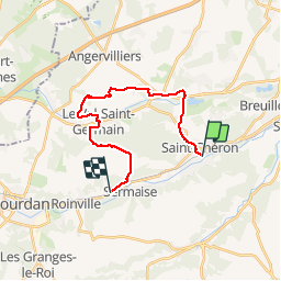
Randonnée Marche de 17,6 km à découvrir à Île-de-France, Essonne, Saint-Chéron. Cette randonnée est proposée par Randonneur94.

Description

Randonnée Gare à Gare.A St Cher
R.Sermaise.
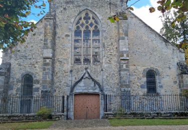
A voir Château Du Marais

Profil altimétrique

Points d'intérêt

Point d'intérêt Saint-Chéron - 0000049 - Photo
Randonneur94
SAINT-CHÉRON 
Point d'intérêt Angervilliers - Table - Photo
Randonneur94
ANGERVILLIERS 
Point d'intérêt Sermaise - 0000051 - Photo
Randonneur94
SERMAISE 

Localisation

Pays :
France
Région :
Île-de-France
Département/Province :
Essonne
Commune :
Saint-Chéron
Localité :
Unknown
Départ:(Dec)
Départ:(UTM)
435490 ; 5377913 (31U) N.

Randonnées à proximité

Randonnée Marche Saint-Sulpice-de-Favières - Les Pétales de Souzy - Photo
Marche
tracegps

Marche

Difficile
(1)
Saint-Sulpice-de-Favières, Île-de-France, Essonne, France
23 km | 29 km-effort
4h 49min
Oui
Randonnée Marche Saint-Sulpice-de-Favières - St Sulpice - Photo
Marche
Auger91

Marche

Moyen
(1)
Saint-Sulpice-de-Favières, Île-de-France, Essonne, France
8 km | 10,1 km-effort
2h 18min
Oui
Randonnée Marche Sermaise - 2018-09-26 Rando Sermaise - Photo
Marche
jchezlemas

Marche

Facile
(1)
Sermaise, Île-de-France, Essonne, France
12,3 km | 15 km-effort
3h 15min
Oui
Randonnée Marche Saint-Chéron - De Saint Chéron à Dourdan par les côteaux de la rive gauche - Photo
Marche
philippebenne

Marche

Difficile
(1)
Saint-Chéron, Île-de-France, Essonne, France
13,5 km | 17 km-effort
3h 51min
Non
Randonnée Marche Villeconin - Villeconin - Photo
Marche
guydu41

Marche

Moyen
Villeconin, Île-de-France, Essonne, France
8,5 km | 10,9 km-effort
2h 11min
Oui
Randonnée Marche Saint-Sulpice-de-Favières - Saint-Sulpice-de-Favières - Photo
Marche
guydu41

Marche

Moyen
Saint-Sulpice-de-Favières, Île-de-France, Essonne, France
7,5 km | 9,4 km-effort
1h 55min
Oui
Randonnée Marche Souzy-la-Briche - Carrières de Madagascar à Souzy-la-Briche  - Photo
Marche
guydu41

Marche

Moyen
Souzy-la-Briche, Île-de-France, Essonne, France
6,8 km | 8,3 km-effort
1h 52min
Oui
Randonnée Marche Saint-Maurice-Montcouronne - Boucle St Maurice Montcouronne - Brigitte - Photo
Marche
chessyca

Marche

Très facile
Saint-Maurice-Montcouronne, Île-de-France, Essonne, France
21 km | 24 km-effort
4h 19min
Oui
Randonnée A pied Saint-Sulpice-de-Favières - Randonnée Saint-Sulpice-de-Favieres n°2 - Photo
A pied
Jean Pierre Parent

A pied

Moyen
Saint-Sulpice-de-Favières, Île-de-France, Essonne, France
20 km | 25 km-effort
4h 51min
Oui


Fermer
Mes abonnements