![](/images/other/stat-length.png)
![Randonnée Marche Mercus-Garrabet - Orri de Sauvegarde - Photo](https://media.geolcdn.com/t/1900/400/ext.pjpeg?maxdim=2&url=https%3A%2F%2Fservices.sitytrail.com%2FGeolivesWS%2FDownloadMedia.ashx%3FTrailID%3D108532%26Media%3D1425_2.jpg)
Orri de Sauvegarde
tracegps
Utilisateur
![Longueur](/images/other/stat-length.png)
Longueur
8,7 km
![Altitude max](https://static1.geolcdn.com/siteimages/upload/files/1508320355ic_sort_altitude_max_24dp.png)
Altitude max
1572 m
![Dénivelé positif](https://static1.geolcdn.com/siteimages/upload/files/1508320355ic_sort_den_pos_24dp.png)
Dénivelé positif
516 m
![Km-Effort](/images/other/stat-length.png)
Km-Effort
15,6 km
![Altitude min](https://static1.geolcdn.com/siteimages/upload/files/1508320355ic_sort_altitude_min_24dp.png)
Altitude min
1053 m
![Dénivelé négatif](https://static1.geolcdn.com/siteimages/upload/files/1508320355ic_sort_den_neg_24dp.png)
Dénivelé négatif
519 m
![Boucle](https://static1.geolcdn.com/siteimages/upload/files/16400158638029165_repeat_loop_refresh_sync_direction_icon.png)
Boucle
Oui
Date de création :
2014-12-10 00:00:00.0
Dernière modification :
2014-12-10 00:00:00.0
![Marche](https://static1.geolcdn.com/sitytour/trail-icons/101.png)
4h30
Difficulté : Moyen
![Scannez ce code QR pour ouvrir la randonnée dans l'application SityTrail](https://capi.geolives.com/qq0zvz2zws4bq2lad0pu/sitytour/trails/108532/qr.png?size=200)
Application GPS de randonnée GRATUITE
À propos
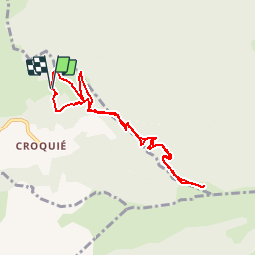
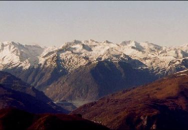
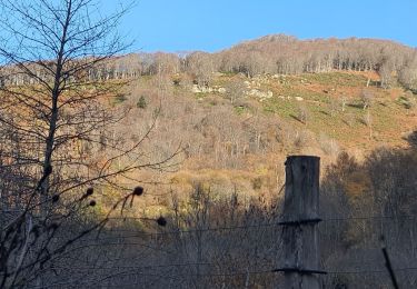
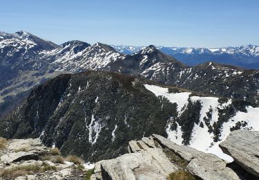
Randonnée Marche de 8,7 km à découvrir à Occitanie, Ariège, Mercus-Garrabet. Cette randonnée est proposée par tracegps.
Description
Un orri est une cabane de berger, petite construction construite en pierres sèches. D’autres informations sont disponibles ICI Balade proposée par le site « Les Balades et Randonnées de Fred »
Localisation
Pays :
France
Région :
Occitanie
Département/Province :
Ariège
Commune :
Mercus-Garrabet
Localité :
Unknown
Départ:(Dec)
Départ:(UTM)
390759 ; 4747757 (31T) N.
Commentaires
Randonnées à proximité
![Randonnée Marche Saint-Paul-de-Jarrat - Le Mont Fourcat - Croquié - Photo](https://media.geolcdn.com/t/375/260/ext.jpg?maxdim=2&url=https%3A%2F%2Fservices.sitytrail.com%2FGeolivesWS%2FDownloadMedia.ashx%3FTrailID%3D111871%26Media%3D8704_3.jpg)
![Marche Marche](https://static1.geolcdn.com/sitytour/trail-icons/101.png)
Le Mont Fourcat - Croquié
Marche
Difficile
(2)
Saint-Paul-de-Jarrat,
Occitanie,
Ariège,
France
![](/images/other/stat-length.png)
10,5 km | 20 km-effort
4h 15min
![](https://static1.geolcdn.com/siteimages/upload/files/16400158638029165_repeat_loop_refresh_sync_direction_icon.png)
Oui
![Randonnée Marche Mercus-Garrabet - Mont Fourcat depuis Croquié - Photo](https://media.geolcdn.com/t/375/260/ext.jpg?maxdim=2&url=https%3A%2F%2Fstatic1.geolcdn.com%2Fsiteimages%2Fupload%2Ffiles%2F1553511878bg_sport_marche.png)
![Marche Marche](https://static1.geolcdn.com/sitytour/trail-icons/101.png)
Mont Fourcat depuis Croquié
Marche
Très difficile
(1)
Mercus-Garrabet,
Occitanie,
Ariège,
France
![](/images/other/stat-length.png)
13 km | 27 km-effort
6h 10min
![](https://static1.geolcdn.com/siteimages/upload/files/16400158638029165_repeat_loop_refresh_sync_direction_icon.png)
Oui
![Randonnée Course à pied Mercus-Garrabet - mercus1 - Photo](https://media.geolcdn.com/t/375/260/ext.jpg?maxdim=2&url=https%3A%2F%2Fstatic1.geolcdn.com%2Fsiteimages%2Fupload%2Ffiles%2F1524743154running.jpg)
![Course à pied Course à pied](https://static1.geolcdn.com/sitytour/trail-icons/103.png)
mercus1
Course à pied
Très facile
(1)
Mercus-Garrabet,
Occitanie,
Ariège,
France
![](/images/other/stat-length.png)
20 km | 37 km-effort
5h 6min
![](https://static1.geolcdn.com/siteimages/upload/files/16400158638029165_repeat_loop_refresh_sync_direction_icon.png)
Oui
![Randonnée Marche Cazenave-Serres-et-Allens - cabane du ¨Pla de Tabe version longue - Photo](https://media.geolcdn.com/t/375/260/147c4153-b5f1-4561-b239-5c27f91ef412.jpg&format=jpg&maxdim=2)
![Marche Marche](https://static1.geolcdn.com/sitytour/trail-icons/101.png)
cabane du ¨Pla de Tabe version longue
Marche
Moyen
Cazenave-Serres-et-Allens,
Occitanie,
Ariège,
France
![](/images/other/stat-length.png)
9,4 km | 19,2 km-effort
4h 22min
![](https://static1.geolcdn.com/siteimages/upload/files/16400158638029165_repeat_loop_refresh_sync_direction_icon.png)
Oui
![Randonnée Marche Mercus-Garrabet - Mont Fourcat en A/R - Photo](https://media.geolcdn.com/t/375/260/fc33e43c-0fba-41f5-9ec5-a4495279cfda.jpg&format=jpg&maxdim=2)
![Marche Marche](https://static1.geolcdn.com/sitytour/trail-icons/101.png)
Mont Fourcat en A/R
Marche
Facile
Mercus-Garrabet,
Occitanie,
Ariège,
France
![](/images/other/stat-length.png)
10 km | 21 km-effort
4h 42min
![](https://static1.geolcdn.com/siteimages/upload/files/16400158638029165_repeat_loop_refresh_sync_direction_icon.png)
Oui
![Randonnée Marche Tarascon-sur-Ariège - Tour de la pique de Tarrascon - Photo](https://media.geolcdn.com/t/375/260/d56397d2-9f78-431f-b676-33a1b154ea61.jpg&format=jpg&maxdim=2)
![Marche Marche](https://static1.geolcdn.com/sitytour/trail-icons/101.png)
Tour de la pique de Tarrascon
Marche
Moyen
Tarascon-sur-Ariège,
Occitanie,
Ariège,
France
![](/images/other/stat-length.png)
11,9 km | 19,3 km-effort
5h 46min
![](https://static1.geolcdn.com/siteimages/upload/files/16400158638029165_repeat_loop_refresh_sync_direction_icon.png)
Oui
![Randonnée A pied Arnave - Le Tour de la Pique - Photo](https://media.geolcdn.com/t/375/260/f87f00e3-985f-4433-a5d5-f942175ed428.jpeg&format=jpg&maxdim=2)
![A pied A pied](https://static1.geolcdn.com/sitytour/trail-icons/100.png)
Le Tour de la Pique
A pied
Facile
Arnave,
Occitanie,
Ariège,
France
![](/images/other/stat-length.png)
9,9 km | 17,3 km-effort
3h 55min
![](https://static1.geolcdn.com/siteimages/upload/files/16400158638029165_repeat_loop_refresh_sync_direction_icon.png)
Oui
![Randonnée Marche Cazenave-Serres-et-Allens - cabane du pla de Tabe en boucle - Photo](https://media.geolcdn.com/t/375/260/4678ea5e-c79c-4ee6-9d6d-246317051217.jpg&format=jpg&maxdim=2)
![Marche Marche](https://static1.geolcdn.com/sitytour/trail-icons/101.png)
cabane du pla de Tabe en boucle
Marche
Moyen
Cazenave-Serres-et-Allens,
Occitanie,
Ariège,
France
![](/images/other/stat-length.png)
9,3 km | 19 km-effort
6h 36min
![Randonnée Marche Cazenave-Serres-et-Allens - cabane du Pla de Tabe en A/R - Photo](https://media.geolcdn.com/t/375/260/fd539e61-1624-4f33-a0bd-23f79cf6ad4a.jpg&format=jpg&maxdim=2)
![Marche Marche](https://static1.geolcdn.com/sitytour/trail-icons/101.png)
cabane du Pla de Tabe en A/R
Marche
Moyen
Cazenave-Serres-et-Allens,
Occitanie,
Ariège,
France
![](/images/other/stat-length.png)
10,5 km | 22 km-effort
7h 10min
![](https://static1.geolcdn.com/siteimages/upload/files/16400158638029165_repeat_loop_refresh_sync_direction_icon.png)
Oui