![](/images/other/stat-length.png)
![Randonnée V.T.T. Saint-Gobain - Les abbayes - Saint Gobain - Photo](https://media.geolcdn.com/t/1900/400/ext.pjpeg?maxdim=2&url=https%3A%2F%2Fservices.sitytrail.com%2FGeolivesWS%2FDownloadMedia.ashx%3FTrailID%3D108489%26Media%3D1209_2.jpg)
Les abbayes - Saint Gobain
tracegps
Utilisateur
![Longueur](/images/other/stat-length.png)
![Altitude max](https://static1.geolcdn.com/siteimages/upload/files/1508320355ic_sort_altitude_max_24dp.png)
![Dénivelé positif](https://static1.geolcdn.com/siteimages/upload/files/1508320355ic_sort_den_pos_24dp.png)
![Km-Effort](/images/other/stat-length.png)
![Altitude min](https://static1.geolcdn.com/siteimages/upload/files/1508320355ic_sort_altitude_min_24dp.png)
![Dénivelé négatif](https://static1.geolcdn.com/siteimages/upload/files/1508320355ic_sort_den_neg_24dp.png)
![Boucle](https://static1.geolcdn.com/siteimages/upload/files/16400158638029165_repeat_loop_refresh_sync_direction_icon.png)
![V.T.T.](https://static1.geolcdn.com/sitytour/trail-icons/202.png)
2h00
Difficulté : Inconnu
![Scannez ce code QR pour ouvrir la randonnée dans l'application SityTrail](https://capi.geolives.com/qq0zvz2zws4bq2lad0pu/sitytour/trails/108489/qr.png?size=200)
Application GPS de randonnée GRATUITE
À propos
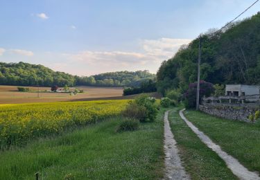
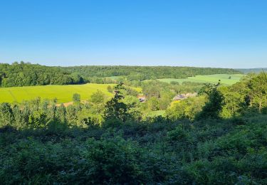
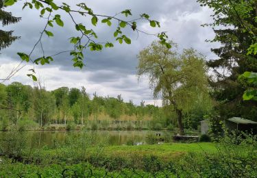
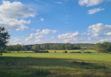
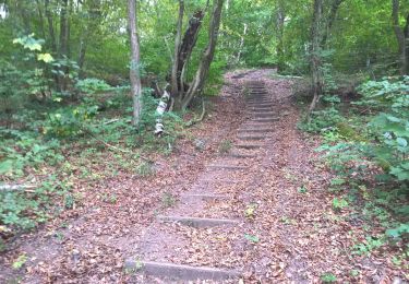
Randonnée V.T.T. de 14,7 km à découvrir à Hauts-de-France, Aisne, Saint-Gobain. Cette randonnée est proposée par tracegps.
Description
Ce circuit extrêmement difficile est réservé aux spécialistes : parfois "trialisant", il demande de sérieuses notions de V.T.T.. Il évolue entre lisières et clairières, entre étangs et vestiges de lieux saints, quasiment millénaires, dans une forêt de hêtres parsemée de chênes aux noms évocateurs : chênes de l'Europe, des Trois-Fillettes...
Localisation
Commentaires
Randonnées à proximité
![Randonnée Marche Septvaux - La route serpentine - Photo](https://media.geolcdn.com/t/375/260/ext.jpg?maxdim=2&url=https%3A%2F%2Fservices.sitytrail.com%2FGeolivesWS%2FDownloadMedia.ashx%3FTrailID%3D202826%26Media%3Dadba97f7-abe9-43ae-b05f-52b1b4639275.jpg)
![Marche Marche](https://static1.geolcdn.com/sitytour/trail-icons/101.png)
Marche
![](/images/other/stat-length.png)
![](https://static1.geolcdn.com/siteimages/upload/files/16400158638029165_repeat_loop_refresh_sync_direction_icon.png)
![Randonnée Marche Saint-Gobain - Les abbayes - Photo](https://media.geolcdn.com/t/375/260/ext.jpg?maxdim=2&url=https%3A%2F%2Fservices.sitytrail.com%2FGeolivesWS%2FDownloadMedia.ashx%3FTrailID%3D108435%26Media%3D1138_2.jpg)
![Marche Marche](https://static1.geolcdn.com/sitytour/trail-icons/101.png)
Marche
![](/images/other/stat-length.png)
![](https://static1.geolcdn.com/siteimages/upload/files/16400158638029165_repeat_loop_refresh_sync_direction_icon.png)
![Randonnée Marche Fourdrain - circuit forêt de Saint-gobain- départ Fourdrain - Photo](https://media.geolcdn.com/t/375/260/cf9bc04d-474a-4a5a-b7fc-0cdb6b92b297.jpg&format=jpg&maxdim=2)
![Marche Marche](https://static1.geolcdn.com/sitytour/trail-icons/101.png)
Marche
![](/images/other/stat-length.png)
![](https://static1.geolcdn.com/siteimages/upload/files/16400158638029165_repeat_loop_refresh_sync_direction_icon.png)
![Randonnée V.T.T. Saint-Gobain - Parcours Errancourt - Photo](https://media.geolcdn.com/t/375/260/34b3f5aa-3647-44ff-87fa-3c17713d300f.jpg&format=jpg&maxdim=2)
![V.T.T. V.T.T.](https://static1.geolcdn.com/sitytour/trail-icons/202.png)
V.T.T.
![](/images/other/stat-length.png)
![](https://static1.geolcdn.com/siteimages/upload/files/16400158638029165_repeat_loop_refresh_sync_direction_icon.png)
![Randonnée Marche Saint-Gobain - parcours Barisis-aux-bois - Photo](https://media.geolcdn.com/t/375/260/b9954d83-3328-4605-a00e-97c373227196.jpg&format=jpg&maxdim=2)
![Marche Marche](https://static1.geolcdn.com/sitytour/trail-icons/101.png)
Marche
![](/images/other/stat-length.png)
![](https://static1.geolcdn.com/siteimages/upload/files/16400158638029165_repeat_loop_refresh_sync_direction_icon.png)
![Randonnée Marche Fourdrain - Parcours Fourdrain - Suzy - Photo](https://media.geolcdn.com/t/375/260/f4738cbe-12e9-4030-8bda-7a4fb7cdec8c.jpg&format=jpg&maxdim=2)
![Marche Marche](https://static1.geolcdn.com/sitytour/trail-icons/101.png)
Marche
![](/images/other/stat-length.png)
![](https://static1.geolcdn.com/siteimages/upload/files/16400158638029165_repeat_loop_refresh_sync_direction_icon.png)
![Randonnée Marche Saint-Gobain - Circuit des Abbayes - Photo](https://media.geolcdn.com/t/375/260/f2886dac-8b35-4900-9be5-d0be8e8de29a.jpg&format=jpg&maxdim=2)
![Marche Marche](https://static1.geolcdn.com/sitytour/trail-icons/101.png)
Marche
![](/images/other/stat-length.png)
![](https://static1.geolcdn.com/siteimages/upload/files/16400158638029165_repeat_loop_refresh_sync_direction_icon.png)
![Randonnée Marche Septvaux - parcours prêt de septvaux - Photo](https://media.geolcdn.com/t/375/260/9ad2963c-4fe7-4c48-a21e-217a026893d4.jpg&format=jpg&maxdim=2)
![Marche Marche](https://static1.geolcdn.com/sitytour/trail-icons/101.png)
Marche
![](/images/other/stat-length.png)
![](https://static1.geolcdn.com/siteimages/upload/files/16400158638029165_repeat_loop_refresh_sync_direction_icon.png)
![Randonnée Marche Saint-Gobain - errancourt-saint Nicolas aux bois - Photo](https://media.geolcdn.com/t/375/260/6c9164f8-faee-4451-b655-414818557cb2.jpg&format=jpg&maxdim=2)
![Marche Marche](https://static1.geolcdn.com/sitytour/trail-icons/101.png)
Marche
![](/images/other/stat-length.png)
![](https://static1.geolcdn.com/siteimages/upload/files/16400158638029165_repeat_loop_refresh_sync_direction_icon.png)