![](/images/other/stat-length.png)
![Randonnée Marche Trescléoux - Tour des Baronnies du Buëch - Trescleoux - Serres - Photo](https://media.geolcdn.com/t/1900/400/ext.pjpeg?maxdim=2&url=https%3A%2F%2Fservices.sitytrail.com%2FGeolivesWS%2FDownloadMedia.ashx%3FTrailID%3D108462%26Media%3D1174_1.jpg)
Tour des Baronnies du Buëch - Trescleoux - Serres
tracegps
Utilisateur
![Longueur](/images/other/stat-length.png)
![Altitude max](https://static1.geolcdn.com/siteimages/upload/files/1508320355ic_sort_altitude_max_24dp.png)
![Dénivelé positif](https://static1.geolcdn.com/siteimages/upload/files/1508320355ic_sort_den_pos_24dp.png)
![Km-Effort](/images/other/stat-length.png)
![Altitude min](https://static1.geolcdn.com/siteimages/upload/files/1508320355ic_sort_altitude_min_24dp.png)
![Dénivelé négatif](https://static1.geolcdn.com/siteimages/upload/files/1508320355ic_sort_den_neg_24dp.png)
![Boucle](https://static1.geolcdn.com/siteimages/upload/files/16400158638029165_repeat_loop_refresh_sync_direction_icon.png)
![Marche](https://static1.geolcdn.com/sitytour/trail-icons/101.png)
4h30
Difficulté : Difficile
![Scannez ce code QR pour ouvrir la randonnée dans l'application SityTrail](https://capi.geolives.com/qq0zvz2zws4bq2lad0pu/sitytour/trails/108462/qr.png?size=200)
Application GPS de randonnée GRATUITE
À propos
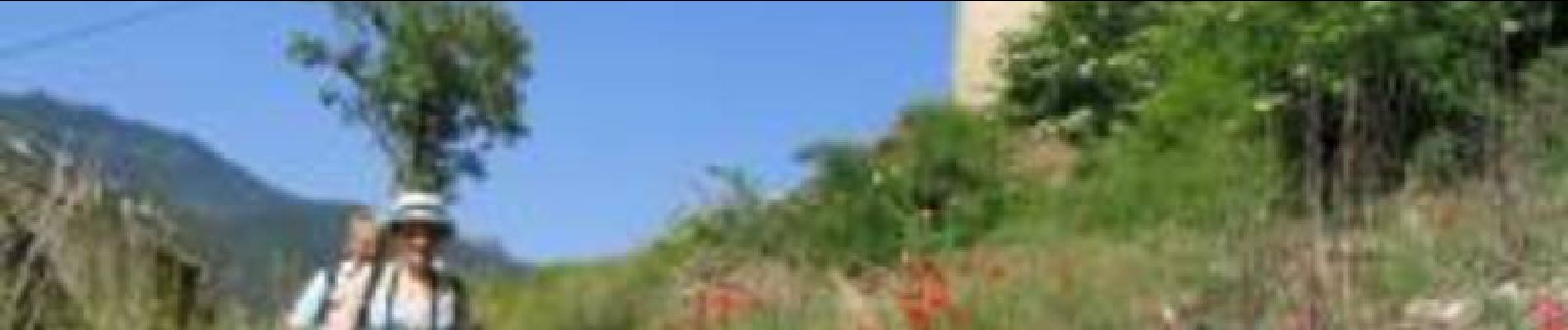
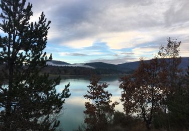
Randonnée Marche de 12,7 km à découvrir à Provence-Alpes-Côte d'Azur, Hautes-Alpes, Trescléoux. Cette randonnée est proposée par tracegps.
Description
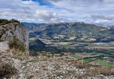
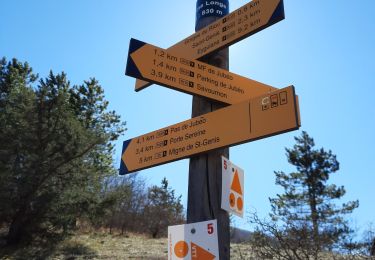
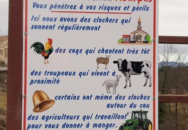
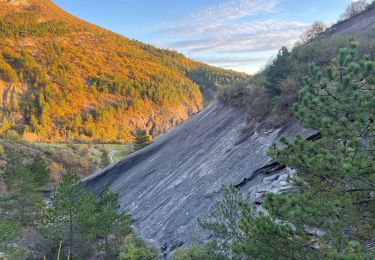
Le tout nouveau Tour des Baronnies du Buëch est un projet initié par la communauté des communes interdépartementale des Baronnies. « Colonne vertébrale » de la petite randonnée dans le Buëch, il constitue un produit d’appel pour la randonnée sur notre territoire. Cette itinéraire en crête offre des paysages somptueux tout en gardant une vue sur l’itinéraire réalisé et à parcourir. Cette étape fait la liaison avec Serres par la crête d'Aumage. Deux sites remarquables sur cet itinéraire: (La grotte d'Aumage, ou des Mazelières) et le "nez" de Beaumont(1544m) qui constitue un splendide et vertigineux promontoire au dessus de la vallée du Buëch. La Montée est longue est soutenue, la descente parfois assez raide. (Les moins chevronnés pourront descendre par Montclus, mais il faut prévoir une liaison par la route) D’autres informations, carte et road-book sont disponibles ICI
Localisation
Commentaires
Randonnées à proximité
![Randonnée A pied Garde-Colombe - Revuaire - Photo](https://media.geolcdn.com/t/375/260/45205769-c963-4aa4-aab1-0aabd1d8813a.jpg&format=jpg&maxdim=2)
![A pied A pied](https://static1.geolcdn.com/sitytour/trail-icons/100.png)
A pied
![](/images/other/stat-length.png)
![](https://static1.geolcdn.com/siteimages/upload/files/16400158638029165_repeat_loop_refresh_sync_direction_icon.png)
![Randonnée Marche Garde-Colombe - R33 La Montagne de Saint Genis - Photo](https://media.geolcdn.com/t/375/260/ext.jpg?maxdim=2&url=https%3A%2F%2Fservices.sitytrail.com%2FGeolivesWS%2FDownloadMedia.ashx%3FTrailID%3D890892%26Media%3Dd0af1630-8a1e-4745-bff6-c393ddd91697.jpg)
![Marche Marche](https://static1.geolcdn.com/sitytour/trail-icons/101.png)
Marche
![](/images/other/stat-length.png)
![](https://static1.geolcdn.com/siteimages/upload/files/16400158638029165_repeat_loop_refresh_sync_direction_icon.png)
![Randonnée Marche Garde-Colombe - Le réduire.. gorge du riou - Photo](https://media.geolcdn.com/t/375/260/3c310a86-c1e4-42e9-b56e-cfcd18924e38.jpg&format=jpg&maxdim=2)
![Marche Marche](https://static1.geolcdn.com/sitytour/trail-icons/101.png)
Marche
![](/images/other/stat-length.png)
![](https://static1.geolcdn.com/siteimages/upload/files/16400158638029165_repeat_loop_refresh_sync_direction_icon.png)
![Randonnée Marche Trescléoux - TRESCLEOUX Les granges de la montagne o s - Photo](https://media.geolcdn.com/t/375/260/d4139a1d-235b-4693-b7cd-01eb7b25235b.jpg&format=jpg&maxdim=2)
![Marche Marche](https://static1.geolcdn.com/sitytour/trail-icons/101.png)
Marche
![](/images/other/stat-length.png)
![](https://static1.geolcdn.com/siteimages/upload/files/16400158638029165_repeat_loop_refresh_sync_direction_icon.png)
![Randonnée V.T.T. Garde-Colombe - Pas du Colombier - Photo](https://media.geolcdn.com/t/375/260/6ef42281-a958-4b30-b76a-71b69ca13d3b.jpg&format=jpg&maxdim=2)
![V.T.T. V.T.T.](https://static1.geolcdn.com/sitytour/trail-icons/202.png)
V.T.T.
![](/images/other/stat-length.png)
![](https://static1.geolcdn.com/siteimages/upload/files/16400158638029165_repeat_loop_refresh_sync_direction_icon.png)
![Randonnée Marche Orpierre - rocher st Michel - Photo](https://media.geolcdn.com/t/375/260/ext.jpg?maxdim=2&url=https%3A%2F%2Fservices.sitytrail.com%2FGeolivesWS%2FDownloadMedia.ashx%3FTrailID%3D569402%26Media%3Dfix__20160425114304.jpg)
![Marche Marche](https://static1.geolcdn.com/sitytour/trail-icons/101.png)
Marche
![](/images/other/stat-length.png)
![](https://static1.geolcdn.com/siteimages/upload/files/16400158638029165_repeat_loop_refresh_sync_direction_icon.png)
![Randonnée Marche Garde-Colombe - St-genis - Photo](https://media.geolcdn.com/t/375/260/82fd0028-f775-47ed-bf2c-39670ba12d33.jpg&format=jpg&maxdim=2)
![Marche Marche](https://static1.geolcdn.com/sitytour/trail-icons/101.png)
Marche
![](/images/other/stat-length.png)
![](https://static1.geolcdn.com/siteimages/upload/files/16400158638029165_repeat_loop_refresh_sync_direction_icon.png)
![Randonnée Marche Trescléoux - TRESCLEOUX .GRANGES DE CHANOUSSE O - Photo](https://media.geolcdn.com/t/375/260/53f4cc1e-2c32-49c3-a4d1-738f80599446.jpg&format=jpg&maxdim=2)
![Marche Marche](https://static1.geolcdn.com/sitytour/trail-icons/101.png)
Marche
![](/images/other/stat-length.png)
![](https://static1.geolcdn.com/siteimages/upload/files/16400158638029165_repeat_loop_refresh_sync_direction_icon.png)
![Randonnée Marche Garde-Colombe - Plan d’eau de St Genis - Photo](https://media.geolcdn.com/t/375/260/82b3a269-e611-48f3-8761-280e72dad930.jpg&format=jpg&maxdim=2)
![Marche Marche](https://static1.geolcdn.com/sitytour/trail-icons/101.png)
Marche
![](/images/other/stat-length.png)
![](https://static1.geolcdn.com/siteimages/upload/files/16400158638029165_repeat_loop_refresh_sync_direction_icon.png)