![](/images/other/stat-length.png)
![Randonnée Marche Rosans - Tour des Baronnies du Buëch - Rosans - Les Viarrands - Photo](https://media.geolcdn.com/t/1900/400/ext.pjpeg?maxdim=2&url=https%3A%2F%2Fservices.sitytrail.com%2FGeolivesWS%2FDownloadMedia.ashx%3FTrailID%3D108457%26Media%3D1169_1.jpg)
Tour des Baronnies du Buëch - Rosans - Les Viarrands
tracegps
Utilisateur
![Longueur](/images/other/stat-length.png)
![Altitude max](https://static1.geolcdn.com/siteimages/upload/files/1508320355ic_sort_altitude_max_24dp.png)
![Dénivelé positif](https://static1.geolcdn.com/siteimages/upload/files/1508320355ic_sort_den_pos_24dp.png)
![Km-Effort](/images/other/stat-length.png)
![Altitude min](https://static1.geolcdn.com/siteimages/upload/files/1508320355ic_sort_altitude_min_24dp.png)
![Dénivelé négatif](https://static1.geolcdn.com/siteimages/upload/files/1508320355ic_sort_den_neg_24dp.png)
![Boucle](https://static1.geolcdn.com/siteimages/upload/files/16400158638029165_repeat_loop_refresh_sync_direction_icon.png)
![Marche](https://static1.geolcdn.com/sitytour/trail-icons/101.png)
3h30
Difficulté : Moyen
![Scannez ce code QR pour ouvrir la randonnée dans l'application SityTrail](https://capi.geolives.com/qq0zvz2zws4bq2lad0pu/sitytour/trails/108457/qr.png?size=200)
Application GPS de randonnée GRATUITE
À propos
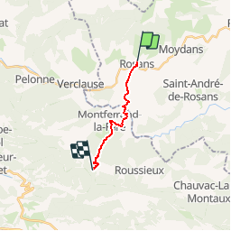
Randonnée Marche de 9,8 km à découvrir à Provence-Alpes-Côte d'Azur, Hautes-Alpes, Rosans. Cette randonnée est proposée par tracegps.
Description
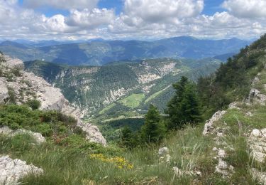
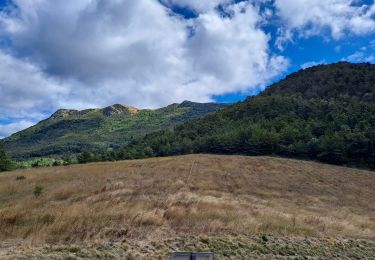
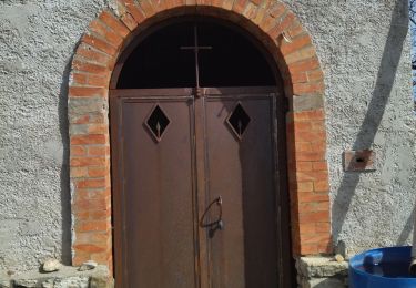
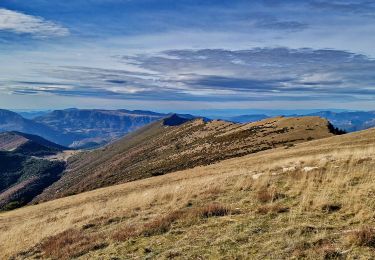
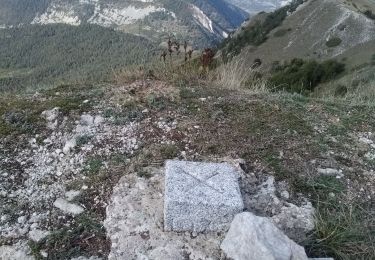
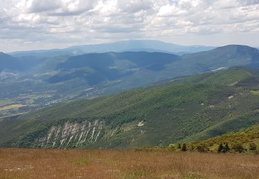
Le tout nouveau Tour des Baronnies du Buëch est un projet initié par la communauté des communes interdépartementale des Baronnies. « Colonne vertébrale » de la petite randonnée dans le Buëch, il constitue un produit d’appel pour la randonnée sur notre territoire. Cette itinéraire en crête offre des paysages somptueux tout en gardant une vue sur l’itinéraire réalisé et à parcourir. La 3ème étape est certainement la plus facile surtout au début: chemins carossables, petite route tranquille en vallée, .... Il y a pourtant plus de montée que de descente. La difficulté sera sur la fin de l'Etape. L'étape étant assez courte, n'hésitez pas à prendre le temps de visiter Rosans, un village médiéval très riche en monument. En particulier sa tour carré, son écomusée... D’autres informations, carte et road-book sont disponibles ICI
Localisation
Commentaires
Randonnées à proximité
![Randonnée Marche nordique Rosans - Crêtes du raton à partir du col de Pommerol - Photo](https://media.geolcdn.com/t/375/260/ce74893b-bcd8-461a-8afe-7c5344df54b3.jpg&format=jpg&maxdim=2)
![Marche nordique Marche nordique](https://static1.geolcdn.com/sitytour/trail-icons/102.png)
Marche nordique
![](/images/other/stat-length.png)
![](https://static1.geolcdn.com/siteimages/upload/files/16400158638029165_repeat_loop_refresh_sync_direction_icon.png)
![Randonnée Marche Rosans - Le Fourchat - Photo](https://media.geolcdn.com/t/375/260/7f174db1-94bf-4048-baf9-e56696ece47f.jpg&format=jpg&maxdim=2)
![Marche Marche](https://static1.geolcdn.com/sitytour/trail-icons/101.png)
Marche
![](/images/other/stat-length.png)
![](https://static1.geolcdn.com/siteimages/upload/files/16400158638029165_repeat_loop_refresh_sync_direction_icon.png)
![Randonnée Marche Saint-André-de-Rosans - 05 risou - Photo](https://media.geolcdn.com/t/375/260/886b94ce-dd23-4d47-93fa-da54bf563cfa.jpg&format=jpg&maxdim=2)
![Marche Marche](https://static1.geolcdn.com/sitytour/trail-icons/101.png)
Marche
![](/images/other/stat-length.png)
![](https://static1.geolcdn.com/siteimages/upload/files/16400158638029165_repeat_loop_refresh_sync_direction_icon.png)
![Randonnée Marche Rosans - Crête de Raton Via Raton - Photo](https://media.geolcdn.com/t/375/260/3e9ccc6f-4f06-44dd-9d37-5eaabb2c9ea0.jpg&format=jpg&maxdim=2)
![Marche Marche](https://static1.geolcdn.com/sitytour/trail-icons/101.png)
Marche
![](/images/other/stat-length.png)
![](https://static1.geolcdn.com/siteimages/upload/files/16400158638029165_repeat_loop_refresh_sync_direction_icon.png)
![Randonnée Marche Rosans - 7km Fourchat AR par chemin du facteur (partie) - Photo](https://media.geolcdn.com/t/375/260/18cea4ea-f64c-464e-b93c-f5601bfe95d1.jpg&format=jpg&maxdim=2)
![Marche Marche](https://static1.geolcdn.com/sitytour/trail-icons/101.png)
Marche
![](/images/other/stat-length.png)
![](https://static1.geolcdn.com/siteimages/upload/files/16400158638029165_repeat_loop_refresh_sync_direction_icon.png)
![Randonnée Marche Rosans - Le Fourchat par le col de Pommerol - Photo](https://media.geolcdn.com/t/375/260/cfab902e-83fa-4d54-aaa2-8926b38ea959.jpg&format=jpg&maxdim=2)
![Marche Marche](https://static1.geolcdn.com/sitytour/trail-icons/101.png)
Marche
![](/images/other/stat-length.png)
![](https://static1.geolcdn.com/siteimages/upload/files/16400158638029165_repeat_loop_refresh_sync_direction_icon.png)
![Randonnée Marche Rosans - Montagne de Raton au départ du col de Pommerol ou de la Fromagère - Photo](https://media.geolcdn.com/t/375/260/88563a29-0d69-4d1d-a9a8-ed2b63e53039.jpg&format=jpg&maxdim=2)
![Marche Marche](https://static1.geolcdn.com/sitytour/trail-icons/101.png)
Marche
![](/images/other/stat-length.png)
![](https://static1.geolcdn.com/siteimages/upload/files/16400158638029165_repeat_loop_refresh_sync_direction_icon.png)
![Randonnée Marche Rosans - POMMEROL - LA MONTAGNE DE RATON - Photo](https://media.geolcdn.com/t/375/260/904beef7-15df-4454-b310-e33a491109ff.jpg&format=jpg&maxdim=2)
![Marche Marche](https://static1.geolcdn.com/sitytour/trail-icons/101.png)
Marche
![](/images/other/stat-length.png)
![](https://static1.geolcdn.com/siteimages/upload/files/16400158638029165_repeat_loop_refresh_sync_direction_icon.png)
![Randonnée Marche Saint-André-de-Rosans - SAINT ANDRE DE ROSANS - SERRE DE BOUT - Photo](https://media.geolcdn.com/t/375/260/73bdb372-6b96-4f24-8ee0-8d047a0b55f7.jpg&format=jpg&maxdim=2)
![Marche Marche](https://static1.geolcdn.com/sitytour/trail-icons/101.png)
Marche
![](/images/other/stat-length.png)
![](https://static1.geolcdn.com/siteimages/upload/files/16400158638029165_repeat_loop_refresh_sync_direction_icon.png)
bien