![](/images/other/stat-length.png)
![Randonnée Marche Cuffies - La pierre à sel - Photo](https://media.geolcdn.com/t/1900/400/ext.pjpeg?maxdim=2&url=https%3A%2F%2Fservices.sitytrail.com%2FGeolivesWS%2FDownloadMedia.ashx%3FTrailID%3D108400%26Media%3D1084_1.jpg)
La pierre à sel
tracegps
Utilisateur
![Longueur](/images/other/stat-length.png)
Longueur
18,3 km
![Altitude max](https://static1.geolcdn.com/siteimages/upload/files/1508320355ic_sort_altitude_max_24dp.png)
Altitude max
153 m
![Dénivelé positif](https://static1.geolcdn.com/siteimages/upload/files/1508320355ic_sort_den_pos_24dp.png)
Dénivelé positif
298 m
![Km-Effort](/images/other/stat-length.png)
Km-Effort
22 km
![Altitude min](https://static1.geolcdn.com/siteimages/upload/files/1508320355ic_sort_altitude_min_24dp.png)
Altitude min
54 m
![Dénivelé négatif](https://static1.geolcdn.com/siteimages/upload/files/1508320355ic_sort_den_neg_24dp.png)
Dénivelé négatif
299 m
![Boucle](https://static1.geolcdn.com/siteimages/upload/files/16400158638029165_repeat_loop_refresh_sync_direction_icon.png)
Boucle
Oui
Date de création :
2014-12-10 00:00:00.0
Dernière modification :
2014-12-10 00:00:00.0
![Marche](https://static1.geolcdn.com/sitytour/trail-icons/101.png)
6h00
Difficulté : Inconnu
![Scannez ce code QR pour ouvrir la randonnée dans l'application SityTrail](https://capi.geolives.com/qq0zvz2zws4bq2lad0pu/sitytour/trails/108400/qr.png?size=200)
Application GPS de randonnée GRATUITE
À propos
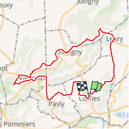
Randonnée Marche de 18,3 km à découvrir à Hauts-de-France, Aisne, Cuffies. Cette randonnée est proposée par tracegps.
Description
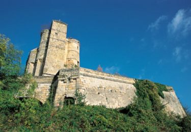
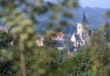
Passé le ru de Juvigny, le circuit rejoint la pierre à sel sur la place de Chavigny puis, à travers le marais, les vestiges de l'oppidum de Noviodunum (point de ralliement des Suessions), dont César ne put s'emparer en 57 av. J.-C. Toutes les infos sont ICI
Localisation
Pays :
France
Région :
Hauts-de-France
Département/Province :
Aisne
Commune :
Cuffies
Localité :
Unknown
Départ:(Dec)
Départ:(UTM)
523202 ; 5472579 (31U) N.
Commentaires
Randonnées à proximité
![Randonnée Marche Clamecy - GR 12 de Clamecy à Sancy les Cheminots - Photo](https://media.geolcdn.com/t/375/260/9172124e-9602-4661-a170-a35a4bbaf66c.jpeg&format=jpg&maxdim=2)
![Marche Marche](https://static1.geolcdn.com/sitytour/trail-icons/101.png)
GR 12 de Clamecy à Sancy les Cheminots
Marche
Très facile
Clamecy,
Hauts-de-France,
Aisne,
France
![](/images/other/stat-length.png)
19,5 km | 25 km-effort
6h 19min
![](https://static1.geolcdn.com/siteimages/upload/files/16400158638029165_repeat_loop_refresh_sync_direction_icon.png)
Non
![Randonnée Vélo Soissons - Sortir de la Crise ! - Soissons - Photo](https://media.geolcdn.com/t/375/260/ext.jpg?maxdim=2&url=https%3A%2F%2Fservices.sitytrail.com%2FGeolivesWS%2FDownloadMedia.ashx%3FTrailID%3D112716%26Media%3D11626_6.jpg)
![Vélo Vélo](https://static1.geolcdn.com/sitytour/trail-icons/200.png)
Sortir de la Crise ! - Soissons
Vélo
Moyen
Soissons,
Hauts-de-France,
Aisne,
France
![](/images/other/stat-length.png)
58 km | 67 km-effort
3h 0min
![](https://static1.geolcdn.com/siteimages/upload/files/16400158638029165_repeat_loop_refresh_sync_direction_icon.png)
Oui
![Randonnée Marche Pasly - Pasly du 24-09-2022 - Photo](https://media.geolcdn.com/t/375/260/be23c5b3-7cbc-4963-8eaa-9a72f611c4e8.jpg&format=jpg&maxdim=2)
![Marche Marche](https://static1.geolcdn.com/sitytour/trail-icons/101.png)
Pasly du 24-09-2022
Marche
Très difficile
Pasly,
Hauts-de-France,
Aisne,
France
![](/images/other/stat-length.png)
16,6 km | 20 km-effort
3h 41min
![](https://static1.geolcdn.com/siteimages/upload/files/16400158638029165_repeat_loop_refresh_sync_direction_icon.png)
Oui
![Randonnée Marche Soissons - Flâneries Soissonnaises - Photo](https://media.geolcdn.com/t/375/260/ext.jpg?maxdim=2&url=https%3A%2F%2Fservices.sitytrail.com%2FGeolivesWS%2FDownloadMedia.ashx%3FTrailID%3D202814%26Media%3Dbc00cc23-dacc-48c7-a47b-7d241f92dc56.jpg)
![Marche Marche](https://static1.geolcdn.com/sitytour/trail-icons/101.png)
Flâneries Soissonnaises
Marche
Très facile
Soissons,
Hauts-de-France,
Aisne,
France
![](/images/other/stat-length.png)
2,4 km | 2,7 km-effort
Inconnu
![](https://static1.geolcdn.com/siteimages/upload/files/16400158638029165_repeat_loop_refresh_sync_direction_icon.png)
Oui
![Randonnée V.T.T. Mercin-et-Vaux - Circuit Clovis - Photo](https://media.geolcdn.com/t/375/260/ext.jpg?maxdim=2&url=https%3A%2F%2Fservices.sitytrail.com%2FGeolivesWS%2FDownloadMedia.ashx%3FTrailID%3D108501%26Media%3D1221_2.jpg)
![V.T.T. V.T.T.](https://static1.geolcdn.com/sitytour/trail-icons/202.png)
Circuit Clovis
V.T.T.
Très difficile
Mercin-et-Vaux,
Hauts-de-France,
Aisne,
France
![](/images/other/stat-length.png)
24 km | 29 km-effort
3h 30min
![](https://static1.geolcdn.com/siteimages/upload/files/16400158638029165_repeat_loop_refresh_sync_direction_icon.png)
Oui
![Randonnée V.T.T. Pommiers - Le ru de Juvigny - Photo](https://media.geolcdn.com/t/375/260/ext.jpg?maxdim=2&url=https%3A%2F%2Fservices.sitytrail.com%2FGeolivesWS%2FDownloadMedia.ashx%3FTrailID%3D108499%26Media%3D1219_2.jpg)
![V.T.T. V.T.T.](https://static1.geolcdn.com/sitytour/trail-icons/202.png)
Le ru de Juvigny
V.T.T.
Moyen
Pommiers,
Hauts-de-France,
Aisne,
France
![](/images/other/stat-length.png)
22 km | 25 km-effort
2h 30min
![](https://static1.geolcdn.com/siteimages/upload/files/16400158638029165_repeat_loop_refresh_sync_direction_icon.png)
Oui
![Randonnée Marche Soissons - Les Monts - Photo](https://media.geolcdn.com/t/375/260/ext.jpg?maxdim=2&url=https%3A%2F%2Fservices.sitytrail.com%2FGeolivesWS%2FDownloadMedia.ashx%3FTrailID%3D108399%26Media%3D1083_2.jpg)
![Marche Marche](https://static1.geolcdn.com/sitytour/trail-icons/101.png)
Les Monts
Marche
Très facile
Soissons,
Hauts-de-France,
Aisne,
France
![](/images/other/stat-length.png)
18,9 km | 22 km-effort
6h 30min
![](https://static1.geolcdn.com/siteimages/upload/files/16400158638029165_repeat_loop_refresh_sync_direction_icon.png)
Oui
![Randonnée Marche Mercin-et-Vaux - Les chemins des hauts champs - Photo](https://media.geolcdn.com/t/375/260/ext.jpg?maxdim=2&url=https%3A%2F%2Fservices.sitytrail.com%2FGeolivesWS%2FDownloadMedia.ashx%3FTrailID%3D108398%26Media%3D1082_2.jpg)
![Marche Marche](https://static1.geolcdn.com/sitytour/trail-icons/101.png)
Les chemins des hauts champs
Marche
Moyen
Mercin-et-Vaux,
Hauts-de-France,
Aisne,
France
![](/images/other/stat-length.png)
9,3 km | 11,8 km-effort
2h 0min
![](https://static1.geolcdn.com/siteimages/upload/files/16400158638029165_repeat_loop_refresh_sync_direction_icon.png)
Oui
![Randonnée Marche Terny-Sorny - Autour de Montgarny - Photo](https://media.geolcdn.com/t/375/260/ext.jpg?maxdim=2&url=https%3A%2F%2Fservices.sitytrail.com%2FGeolivesWS%2FDownloadMedia.ashx%3FTrailID%3D108333%26Media%3D1004_1.jpg)
![Marche Marche](https://static1.geolcdn.com/sitytour/trail-icons/101.png)
Autour de Montgarny
Marche
Moyen
Terny-Sorny,
Hauts-de-France,
Aisne,
France
![](/images/other/stat-length.png)
8,9 km | 11,1 km-effort
2h 45min
![](https://static1.geolcdn.com/siteimages/upload/files/16400158638029165_repeat_loop_refresh_sync_direction_icon.png)
Oui