![](/images/other/stat-length.png)
![Randonnée Marche Laon - Les remparts - Photo](https://media.geolcdn.com/t/1900/400/ext.pjpeg?maxdim=2&url=https%3A%2F%2Fservices.sitytrail.com%2FGeolivesWS%2FDownloadMedia.ashx%3FTrailID%3D108356%26Media%3D1032_2.jpg)
Les remparts
tracegps
Utilisateur
![Longueur](/images/other/stat-length.png)
Longueur
5,6 km
![Altitude max](https://static1.geolcdn.com/siteimages/upload/files/1508320355ic_sort_altitude_max_24dp.png)
Altitude max
186 m
![Dénivelé positif](https://static1.geolcdn.com/siteimages/upload/files/1508320355ic_sort_den_pos_24dp.png)
Dénivelé positif
75 m
![Km-Effort](/images/other/stat-length.png)
Km-Effort
6,6 km
![Altitude min](https://static1.geolcdn.com/siteimages/upload/files/1508320355ic_sort_altitude_min_24dp.png)
Altitude min
152 m
![Dénivelé négatif](https://static1.geolcdn.com/siteimages/upload/files/1508320355ic_sort_den_neg_24dp.png)
Dénivelé négatif
74 m
![Boucle](https://static1.geolcdn.com/siteimages/upload/files/16400158638029165_repeat_loop_refresh_sync_direction_icon.png)
Boucle
Oui
Date de création :
2014-12-10 00:00:00.0
Dernière modification :
2014-12-10 00:00:00.0
![Marche](https://static1.geolcdn.com/sitytour/trail-icons/101.png)
2h00
Difficulté : Moyen
![Scannez ce code QR pour ouvrir la randonnée dans l'application SityTrail](https://capi.geolives.com/qq0zvz2zws4bq2lad0pu/sitytour/trails/108356/qr.png?size=200)
Application GPS de randonnée GRATUITE
À propos
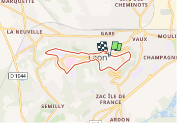
Randonnée Marche de 5,6 km à découvrir à Hauts-de-France, Aisne, Laon. Cette randonnée est proposée par tracegps.
Description
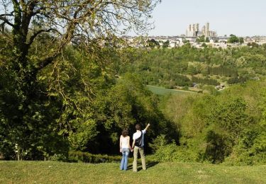
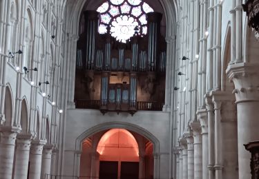
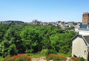
Dominant la campagne environnante, la fière ville haute de Laon, couronnée de la cathédrale Notre-Dame, recèle des trésors architecturaux à découvrir au cours de cette promenade urbaine. Toutes les infos sont ICI
Localisation
Pays :
France
Région :
Hauts-de-France
Département/Province :
Aisne
Commune :
Laon
Localité :
Unknown
Départ:(Dec)
Départ:(UTM)
545185 ; 5490415 (31U) N.
Commentaires
Randonnées à proximité
![Randonnée Marche Laon - La Butte de Laon - L'eau de bas en haut - Photo](https://media.geolcdn.com/t/375/260/ext.jpg?maxdim=2&url=https%3A%2F%2Fservices.sitytrail.com%2FGeolivesWS%2FDownloadMedia.ashx%3FTrailID%3D110391%26Media%3D5848_1.jpg)
![Marche Marche](https://static1.geolcdn.com/sitytour/trail-icons/101.png)
La Butte de Laon - L'eau de bas en haut
Marche
Moyen
(1)
Laon,
Hauts-de-France,
Aisne,
France
![](/images/other/stat-length.png)
5,4 km | 7,1 km-effort
2h 0min
![](https://static1.geolcdn.com/siteimages/upload/files/16400158638029165_repeat_loop_refresh_sync_direction_icon.png)
Oui
![Randonnée Marche Laon - La campagne dans la ville - Photo](https://media.geolcdn.com/t/375/260/ext.jpg?maxdim=2&url=https%3A%2F%2Fservices.sitytrail.com%2FGeolivesWS%2FDownloadMedia.ashx%3FTrailID%3D202819%26Media%3D8fdb73e3-2275-44e0-bbe5-87d2f19d625d.jpg)
![Marche Marche](https://static1.geolcdn.com/sitytour/trail-icons/101.png)
La campagne dans la ville
Marche
Très facile
Laon,
Hauts-de-France,
Aisne,
France
![](/images/other/stat-length.png)
4,6 km | 6,3 km-effort
Inconnu
![](https://static1.geolcdn.com/siteimages/upload/files/16400158638029165_repeat_loop_refresh_sync_direction_icon.png)
Oui
![Randonnée Marche Laon - RANDO A LAON - Photo](https://media.geolcdn.com/t/375/260/0aa84c13-8d75-4e78-be09-9c0ea34decca.jpg&format=jpg&maxdim=2)
![Marche Marche](https://static1.geolcdn.com/sitytour/trail-icons/101.png)
![Randonnée Marche Laon - Le grand tour de Laon - Photo](https://media.geolcdn.com/t/375/260/a02347ad-a9f0-4106-aaad-61da55c5afc3.jpg&format=jpg&maxdim=2)
![Marche Marche](https://static1.geolcdn.com/sitytour/trail-icons/101.png)
Le grand tour de Laon
Marche
Moyen
Laon,
Hauts-de-France,
Aisne,
France
![](/images/other/stat-length.png)
7,1 km | 9,1 km-effort
2h 0min
![](https://static1.geolcdn.com/siteimages/upload/files/16400158638029165_repeat_loop_refresh_sync_direction_icon.png)
Oui
![Randonnée Marche Laon - Laon - Neuville sur Ailette - Photo](https://media.geolcdn.com/t/375/260/ext.jpg?maxdim=2&url=https%3A%2F%2Fstatic1.geolcdn.com%2Fsiteimages%2Fupload%2Ffiles%2F1553511878bg_sport_marche.png)
![Marche Marche](https://static1.geolcdn.com/sitytour/trail-icons/101.png)
Laon - Neuville sur Ailette
Marche
Très facile
Laon,
Hauts-de-France,
Aisne,
France
![](/images/other/stat-length.png)
20 km | 24 km-effort
5h 6min
![](https://static1.geolcdn.com/siteimages/upload/files/16400158638029165_repeat_loop_refresh_sync_direction_icon.png)
Non
![Randonnée Marche Laon - La campagne dans la ville - Photo](https://media.geolcdn.com/t/375/260/ext.jpg?maxdim=2&url=https%3A%2F%2Fservices.sitytrail.com%2FGeolivesWS%2FDownloadMedia.ashx%3FTrailID%3D108311%26Media%3D982_2.jpg)
![Marche Marche](https://static1.geolcdn.com/sitytour/trail-icons/101.png)
La campagne dans la ville
Marche
Moyen
Laon,
Hauts-de-France,
Aisne,
France
![](/images/other/stat-length.png)
4,6 km | 6,3 km-effort
1h 30min
![](https://static1.geolcdn.com/siteimages/upload/files/16400158638029165_repeat_loop_refresh_sync_direction_icon.png)
Oui
![Randonnée Marche Laon - Laon cité médiévale - Photo](https://media.geolcdn.com/t/375/260/34a40240-9287-4698-883e-22b326431829.jpg&format=jpg&maxdim=2)
![Marche Marche](https://static1.geolcdn.com/sitytour/trail-icons/101.png)
Laon cité médiévale
Marche
Facile
Laon,
Hauts-de-France,
Aisne,
France
![](/images/other/stat-length.png)
2,8 km | 3,3 km-effort
47min
![](https://static1.geolcdn.com/siteimages/upload/files/16400158638029165_repeat_loop_refresh_sync_direction_icon.png)
Oui
![Randonnée Marche Mons-en-Laonnois - Mons en Laonnois - Photo](https://media.geolcdn.com/t/375/260/ext.jpg?maxdim=2&url=https%3A%2F%2Fstatic1.geolcdn.com%2Fsiteimages%2Fupload%2Ffiles%2F1553511878bg_sport_marche.png)
![Marche Marche](https://static1.geolcdn.com/sitytour/trail-icons/101.png)
Mons en Laonnois
Marche
Très facile
Mons-en-Laonnois,
Hauts-de-France,
Aisne,
France
![](/images/other/stat-length.png)
19,9 km | 25 km-effort
5h 34min
![](https://static1.geolcdn.com/siteimages/upload/files/16400158638029165_repeat_loop_refresh_sync_direction_icon.png)
Oui
![Randonnée Marche Laon - Laon Médiéval 3.3 km - Photo](https://media.geolcdn.com/t/375/260/ext.jpg?maxdim=2&url=https%3A%2F%2Fstatic1.geolcdn.com%2Fsiteimages%2Fupload%2Ffiles%2F1553511878bg_sport_marche.png)
![Marche Marche](https://static1.geolcdn.com/sitytour/trail-icons/101.png)
Laon Médiéval 3.3 km
Marche
Facile
Laon,
Hauts-de-France,
Aisne,
France
![](/images/other/stat-length.png)
3,3 km | 4,2 km-effort
56min
![](https://static1.geolcdn.com/siteimages/upload/files/16400158638029165_repeat_loop_refresh_sync_direction_icon.png)
Oui